Mt. St. Helens Destruction, a Photo Gallery.
© 2004 by James Q. Jacobs. All rights reserved.
PREVIOUS PAGE: Mt. St. Helens Eruptions
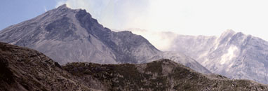
The three images in this table, taken from the north side of the mountain, illustrate the force of the May 18 eruption. Where a beautiful, symmetrical mountain rose, only a massive crater remains. The blast that decapitated the mountain destroyed the pristine forests north of the peak and filled Spirit lake with debris.
The panorama image below combines five images taken from the same tripod position. You can also view a high resolution version of this image (317K, 1960 x 550 pixels) in a new browser window. The panorama also serves as an image map. Clicking parts of the image will open higher resolution files of the individual photographs in new windows.
Although sheltered from the blast by the hill on the left, most of the trees there were nonetheless felled by the tremendous force of the explosion, and all of them were killed by the searing heat. The direction of the fallen trees indicates the location of the mountain. These images were taken five years after the eruption.


