|
2007.03.02 - Chankillo Thirteen Towers
news is getting global headlines:
Ancient Peruvian Astronomical Observatory Noted by
Modern Scientists
 However, noone seems to have
worded it quite that way. Google's News and Blog searches provide a
window into how media editors view the feed on this information.
Different headlines are written at individual media outlets to a story
repeated word-for-word the world over. How the headlines vary is itself
a story, more interesting I'm sure to anthropologists than science news
readers. Too many "solar cult" instances for my taste is why I mention
it. They are repeating the words used in the press release,
"sophisticated Sun cults uncovered." (Photo credit: courtesy of Ivan
Ghezzi.) However, noone seems to have
worded it quite that way. Google's News and Blog searches provide a
window into how media editors view the feed on this information.
Different headlines are written at individual media outlets to a story
repeated word-for-word the world over. How the headlines vary is itself
a story, more interesting I'm sure to anthropologists than science news
readers. Too many "solar cult" instances for my taste is why I mention
it. They are repeating the words used in the press release,
"sophisticated Sun cults uncovered." (Photo credit: courtesy of Ivan
Ghezzi.)
The news and "cult" verbage
is widely repeated already. University of Leicester issued the press release late there yesterday:
The Thirteen
Towers: Peruvian Citadel is Site of
Earliest Ancient Solar Observatory in the Americas
Existence of
sophisticated Sun cults uncovered by
researchers from University of Leicester and Yale University
A 2,300 year old solar
observatory in Peru has been identified by new research published today
(March 2), in the journal Science ....
.... The research was
carried out by Ivan Ghezzi, a graduate student in the Department of
Anthropology at Yale University who is now Archaeological Director of
the Instituto Nacional de Cultura (National Institute for Culture) in
Peru, and Professor Clive Ruggles, of the School of Archaeology and
Ancient History at the University of Leicester. Professor Ruggles is
one of the world's leading authorities on archaeoastronomy.
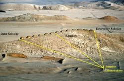
.... "Chankillo ...
provided a complete set of horizon markers - the Thirteen Towers - and
two unique and indisputable observation points," Ruggles said. "The
fact that, as seen from these two points, the towers just span the
solar rising and setting arcs provides the clearest possible indication
that they were built specifically to facilitate sunrise and sunset
observations throughout the seasonal year...."
Much more. See also Science
2 March 2007: Vol. 315:5816, 1239-1243.
Peru is one of my beats,
ancient astronomy another, so this is big news in the right combination
to really change my morning coffee. Casma-Sechin is huge in scale as
monument sites go, so this is not a surprise. The casma.kmz placemark file is
suddenly a wildly popular download. Check out the massive monuments
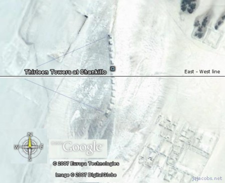
surrounding the Thirteen Towers.
Chankillo Castillo is a
nearby hilltop ruin with possible horizon alignments as seen from the
towers and other Chankillo constructs. Viewing a horizon tower accords
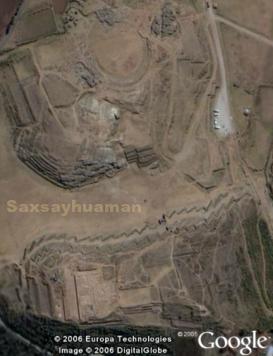
with ethnohistorical reports of horizon towers viewed from Cuzco.
Coincidentally, scroll down for an image of one of the Cuzco towers,
visible atop Saxsayhuaman in
an aerial image. Here follow the Chankillo site coordinates from Google
Earth's digital globe. Does anyone have elevation readings? Chankillo
is higher in elevation in the direction of level lunar major, about 60
degrees from North.
|
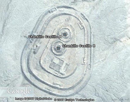
chcaa
|
Chankillo Castillo A
|
-9.556335
|
-78.235729
|
|
chcab
|
Chankillo Castillo B
|
-9.556728
|
-78.235925
|
|
chttc
|
Chankillo Thirteen
Towers
|
-9.561149
|
-78.227355
|
Landscape lines visible in
the Chankillo neighborhood evidence numerous large ancient constructs, including
rectangular enclosures (kankas). More after I read the Science article.
Here again, the casma.kmz
file, plus the press release from Yale University this time.
2008.05.06 - I finally have several
comments on the Science article. First, the statement, sun
pillars "are described by various chroniclers ... but all the Cusco
pillars have vanished without trace and their precise location remains
unknown" is contradicted by the photo above. Second, Chankillo is
located in the Casma River valley, not a basin as stated, "... the
Thirteen Towers is found within Chankillo, a ceremonial center in the
Casma-Sechín River Basin." The rivers join downstream north of
Chankillo before flowing to the sea.
There is an inheret
contradiction in the work, "From the eastern observing point, the
southernmost tower (tower 13) would not have been visible at all, and
the top of tower 12 would only just have been visible..." If the
purpose was as stated, why wouldn't all the structures be visible from
their hypothetical observation point? Also, stairs in each structure
and a flat top infers use atop the structures. The authors make a very
valid point, and like Horn and
Hively, ignore their own advice,
"Astronomical
“explanations” can be fitted notoriously easily to preexisting
alignments.... Fortuitous stellar alignments are particularly likely,
given the number of stars in the sky and the fact that their positions
change steadily over the centuries owing to precession."
Finally, I fail to see the
relationship postulated by these authors, "Given the similarity between
the solar observation device at Chankillo and the Cusco pillars
documented some two millennia later..." Especially in light of their
statement they do not know the locations of the Cuzco towers. The scale
is very different, as is the architecture. Any relationship seems a
far-reaching conjecture. I recently further commented on the "temple
vs. astronomical observatory" issue in another blog, The Ur and
Harran Latitudes, and Göbekli Tepe.
Science is always subject to
review, and I look forward to other analyses of this site, especially
from the persective of the thirteen towers as viewing stations in
relation to Chankillo.
2011.10.17 - A functional consideration regarding observing the cosmos is the geometry of our reference spheres. Latitude
properties expressing integral number relationships to the pole and
equator reinforce astronomical observation interpretations of major
monuments. Several site latitudes nearby have a functional advantage over Chankillo. The Chavin latitude
arcsine
equals one-sixth (asin(1/6) = 9.5941 degrees). A right
triangle at Chavin with sides extended to the pole star and to the
geodetic center expresses the ratio 1:6; the axis is the hypotenuse
equaling six and the geodetic radius equals one.
The latitude
with arctangent
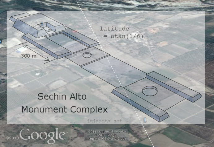
equaling one-sixth (atan(1/6) = 9.46232 degrees) falls in the vicinity of the largest pyramids in the Casma-Sechin, Sechin Alto, Sechin Bajo, and the best-preserved Sechin Alto huaca, Taukachi-Konkan. The latitude
with arctangent
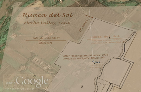
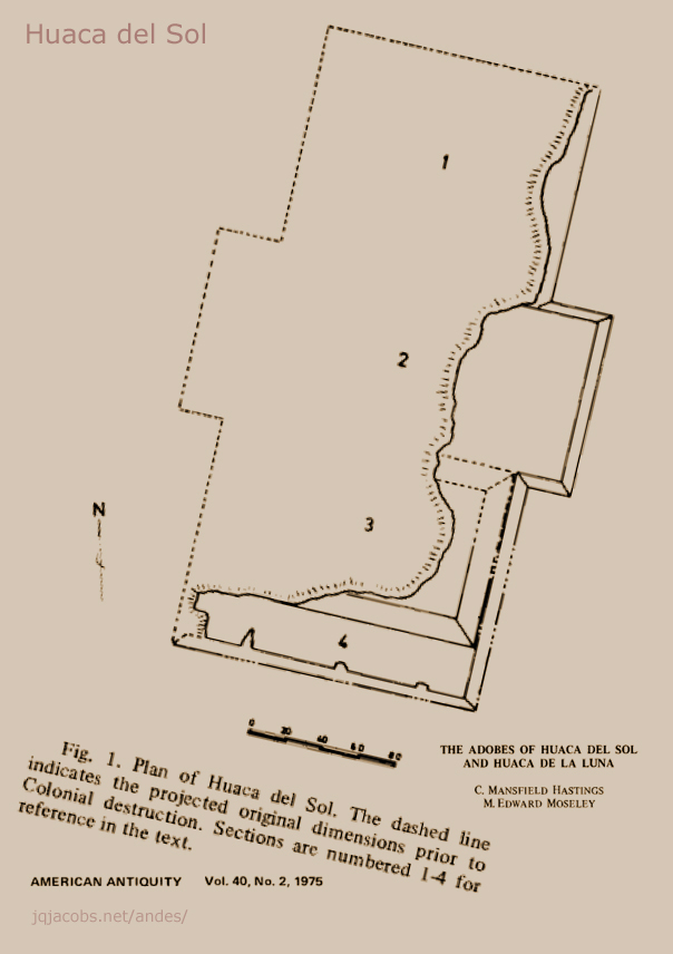
equaling one-seventh (atan 1/7 = 8.13010 degrees) crosses Huaca del Sol, in the Moche Valley. The following aerial image outline of Huaca del Sol is based on the Hastings and Moseley projected basal form. Most of the monument was eroded historically by grave robbers channeling the nearby Moche river. The horizontal iine is the current atan(1/7) latitude.

ArchaeoBlog Home
Page
More
ArchaeoBlog Pages:
Thornborough
Henges and the Ure-Swale Monuments
Neolithic
Monuments in Northeastern Europe Threatened
Summer
Solstice 2006 - Big Horn Medicine Wheel
Google
Earth Placemarks
The Original
ArchaeoBlog Pages:
Mound Builders of the Eastern Woodlands, Fall 2005
Due to family, friends, and students requesting images of my journey
to visit major ancient earthworks in the Ohio Valley region, I started
the
ArchaeoBlog with the following photo galleries. Hopefully, the journals
impart a sense of 'being there now AND long before' while read.
|
| Discourse: Collected discussion
group postings.
|
EDUCATORS: Use my
images free and without hassle - Permissions |
Home | Archaeology | Astronomy | Photo Galleries
| Contact and Feedback
|