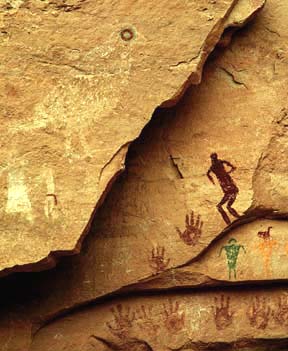
| About five miles downstream from the Bullet Canyon confluence, Step Canyon joins Grand Gulch from the north. Near the mouth of Step Canyon several unique pictographs occur, part of a panel of very colorful glyphs. This site is often referred to as Quail Panel due to the 3-foot painting of a quail, complete with a topknot and a green and brown eye. The eye is both oversized and a dramatic perfect circle. Yellow men with brown duck heads, green men with arcs for heads, a crouching, side view anthropomorph, some very faint white anthropomorphs, a little brown anthropomorph in side view holding an atlatl half again his height, lots of brown handprints and a corn plant are all depicted. Off to the right a very intense looking red and white mask stares directly at the viewer from the sandstone. |

Continuing downstream ducks, duck-headed men, handprints, red and yellow men,
bird figures, white anthropomorphs and long legged birds decorate shelters
within the deep canyon. The hiker will pass Long House Ruin, a well-preserved
structure along a ledge on the right, out of view from the trail in the
arroyo. Here a group of white dots, green men and a large duck are painted.
Just over five miles below Step Canyon, at 24.7 stream miles from Kane
Gulch, one of the panels of large anthropomorphs is found high above the
canyon floor in a northerly facing alcove on the east side. The site is
easy to pass by and well worth the effort to find. One of the large figures
at Big Man Panel has a waist decoration similar to the large anthropomorphs
on the San Juan River at Butler Wash confluence. I suspect that this represents
a skirt. 
|


| Another mile and a half downstream the hiker passes Polly's Canyon
on the east. A spring is located a short distance therein. Polly's Island,
across canyon, is an ancient meander of the Gulch, one of the rare points
where water washed a shorter path through the durable sandstone. An immense
redrock island in the sky has resulted. Along Grand Gulch, at the midpoint
of Polly's Island, Government Trail, one of the few trails in and out of
the Gulch, climbs the east wall. It is a two mile hike from the Gulch to
the end of the very bad nine-mile-long two-track from Highway 261. This
is a difficult trailhead to find, and, as I found out on my exiting in
near darkness, so was my vehicle.
Continuing downstream, a large petroglyph panel, a sort of "Newspaper Rock" with many densely packed figures of varying ages, follows. Some of the figures are very faint. Nearby is a very faint, heavily patinated Archaic Style panel. A four foot high red clay anthropomorph is seen above Round House Ruin. Look for a red shield at Bannister Ruin in a south facing alcove, just before Bannister Spring (7 miles from Government Trailhead, 33.3 miles from Kane Gulch.) Watch for four large Basketmaker anthropomorphs and some smaller Puebloan ones at a site before Collins Canyon. In a rincon just before the side canyon numerous figures are found, including ducks, a Kokopelli, atlatls, and large white anthropomorphs. The Collins Spring trailhead is two miles up this west-side branch canyon. The trailhead is accessed from Utah highway 276, the road to Hall's Crossing on Lake Powell in the Glen Canyon National Recreation Area. At the Collins Canyon confluence (mile 36) Grand Gulch begins tending in a southerly direction, however unevident it is to the hiker dizzied by the continuous meanders. The canyon also becomes shallower in this area and hikers, just as did the prehistoric inhabitants, find themselves less sheltered from summer heat. Deep narrow canyons can be quite cool and refreshing on a hot summer day. A shallow canyon reflects sunlight and can be hotter than the surrounding mesa tops. Be prepared for scorching sunshine to take the place of deep shade from this point downstream. |


| With fewer springs and a less hospitable canyon downstream, less evidence of prehistoric occupation occurs. Over a mile past Big Panel another two sites occur, one near Red Man Canyon, 42.3 miles from Kane Gulch, and another nearby downstream. From this point I made my way out of the Canyon and across the mesa back to my vehicle and Highway 276. I cannot report on the last nine miles of the hike to the San Juan River. |
    
Archaeology
| Astronomy
| Andes | Mesoamerica
| Southwest | Art |