|
Southwest USA - Spring 2007 |
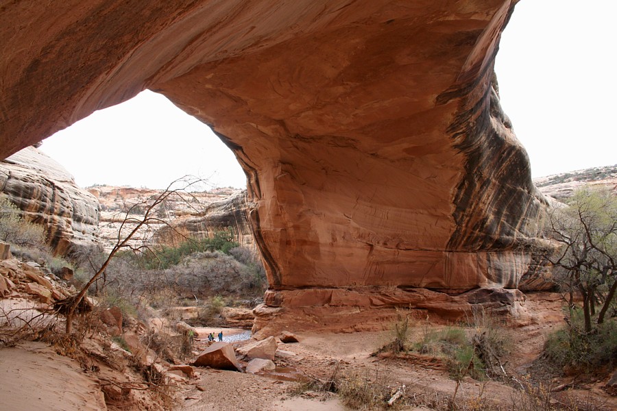
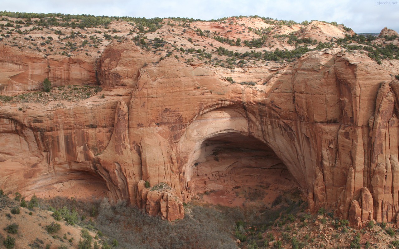
2007.03.25 - I'm on the road again, doing photography and site studies. Grimes Point Archaeological Site, Nevada, was my first archaeology stop. Check out the new photo gallery. You will also find linked there, a 4.5 Mb PowerPoint intended for educator use with images of petroglyphs and interpretations. Yesterday, I photographed Betatakin Ruin and Tsegi Canyon. Recent rains brightened the red rock colors, and clouds kept the light subdued. Download the deskpicture.
2007.03.29 - Today, I had an unusual experience. I'm in the library on the San Juan Campus of Eastern Utah College. I was trying to upload the Natural Bridges National Monument photo gallery, but could not access my server in Los Angeles. I found I could not FTP, could not see site stats, and then found I could not access my domain. For some reason, purportedly unknown even to college administration, my site was inaccessible on the college IT system. Imagine how this impacts potential online students and student research! Apparently, I was blocked. When I raised the "academic freedom" issue, administrator Bob McPherson asked, "Are you from California?" Finally later, as several staff were trying to access the site, it became available. Mr. McPherson said, "See, it is not a communist conspiracy." I was not taking the matter as lightly. I find this issue alarming. They did not admit the domain was blocked. Why would a college in a remote county in Utah block an educational web site? I shall have to inquire further to unravel the mystery. It cut into my work time. First, I spent an hour making sure I was not hacked, and that the site was actually online elsewhere.
New postings today include Great Basin National Park, more images on the Travel page, and the Natural Bridges page. 2007.03.31 - First light, near Holly House, Hoveweep National Monument. It is freezing cold. The keyboard is still cold to the touch, a new sensation. I just discovered the laptop will not start when too cold. Ten minutes under my down vest warmed it and chilled me. I'm car camping and awaiting sunrise. Yesterday was spent filling a 1 GB memory card with images at the main concentration of ruins and at Cajon House, another of the Hovenweep NM outlier ruins. Early yesterday morning I met Rob Bowring, the IT specialist at Eastern Utah College in Blanding. Rob said "It ain't me blocking it" in reference to the unavailability of my domain the previous day on the Utah Education Network. Perhaps I've been listening to too many Congressional hearings, because I noted the present tense of his statement. Rob reports he does not block any domains, and believes he isn't supposed to either. The San Juan Campus connection is "piped in" by the state network. So the issue remains a mystery. The sky is very clear for the first time in about a week. The east face of the Abajo Peaks are brightening. Sleeping Ute Mountain is dark, but I'm on the shade side. And now the first rays of sunshine are striking this longitude. Time to get to work. There is a solar hierophany nearby I don't want to miss.
2007.04.02 - New today, several Hovenweep Photo Galleries.
2007.04.05 - I awoke at first hint of light, and made my way to Yellow Jacket pueblos for sunrise and GPS readings. Alignments of site features with distant mountains has been noted here, so I wanted to capture the horizon sharply silhouetted. I'm now sitting in Spruce Tree Coffee House in Cortez, taking advantage of the dark roast and free wireless. The local site stewards, archaeologists, and museum personnel have been very helpful. Yellow Jacket is private property, owned by the Archaeological Conservancy, and site steward Dennis Boon assisted in accessing the site. Crow Canyon Archaeological Center provides a wealth of online information about the site, including a database with survey maps. These resources and the people I've encountered are making field work both pleasant and productive.
2007.04.05 - New today, images of Cliff Palace and the Sun Towers on Mesa Verde. More Mesa Verde photo galleries will follow soon, from the same link. I had a great day atop the mesa, complete with a very close encounter with a coyote. The calm morning at near 7,000 feet above sea level, at the Far View pueblos, allowed GPS readings with 2m 3-D accuracy.
2007.04.08 - Yesterday, I visited Aztec Ruins National Monument and Salmon Ruins, both sites in northwestern New Mexico. Due to National Park Service regulations, my research was restricted to only one trail at Aztec. What a contrast to the collaborative assistance I encountered from fellow archaeos in the Cortez area. I'm accustomed to the NPS treatment, and yet it is very frustrating to have public servants running bureaucratic interfence with research. I just want to take a few GPS readings, not dig up pottery! I was able to obtain readings for a tri-walled structure, parts of the West Ruin, and a survey datum. Before departing the Cortez area, I also visited Yucca House ruins, an undeveloped National Parks property protecting a large pueblo and a great kiva. Also, I've added new images to the Spruce Tree House page.
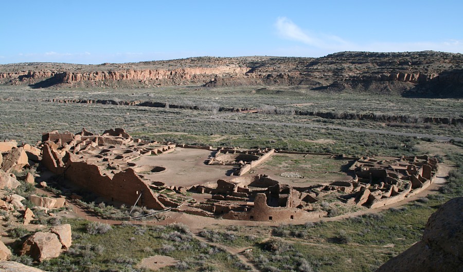
2007.04.13 - After three days at Chaco Canyon, I'm resting in a warm shelter. Some of the Chaco Canyon images are updated, and many more will follow in additional photo galleries of great houses.
I also visited Coronado State Monument, site of Kuaua Pueblo at the time of Coronado's visit.
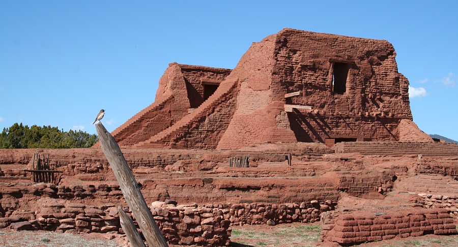
2007.04.22 - I call this day "Cover-Up Day" due to the Royal Decree of 1577, signed on April 22, outlawing writing anything about Native Americans and confiscating writings for review by the Holy Offce of the Inquisition and the Council of the Indies. A few years after the Cover-Up Day idea manifested, Nixon died on April 22. Enjoy Cover-Up Day by celebrating truth. With new GPS readings from Chaco Canyon, some truth of the knowledge involved in constructing the Great Houses may be forthcoming. What did the royals and clerics in 1577 not want us to know? During the last week, while not visiting with friends old and new, I've made an effort to catch up with many GBs of new photography. Soon, the Southwest Archaeology pages will be greatly expanded. Meanwhile, here are a few views, previews of new web pages to follow. In this part of the Southwest, ancient pueblos evidence the imperialism of the crown and the theoracy. Their mission building efforts lay in ruins along with the pueblos they decimated.
2007.04.25 - The Southwest Anthropology and Archaeology Pages are now all updated. More new photo galleries remain to be inserted, and more text will be added. I'm also focused on archaeogeodesy study of the Chacoan and other monumental sites using the new GPS readings, and some interesting results will be announced soon. I'll post the new GPS readings throughout the pages too, and several are there now. 2008.04.16 - The 2007 GPS survey data is now published online. All waypoints and current derived coordinates are in a Southwest Waypoints spreadsheet (sw_waypoints.xls). A first version of the placemarks file is now uploaded. The placemarks illustrate a difference between current Google Earth coordinates in this area and the WGS84 coordinate system. Accuracy on the digital globe varies by region, and coordinates change as updates improve imagery placement. The GPS data is more reliable in accuracy. 2010.02.23 - I posted a dozen PowerPoints of Southwest Photo Galleries. Educator tip: Most of my recent imagery links to high-quality, 900-pixel-wide, 90-dpi JPEGs, or other suited formatting to paste into PPTs at 100%. There are more images in my photo galleries than in the presentation format.
Home | Archaeology | Astronomy | Photo Galleries | Contact and Feedback |
|||||||||||||||||||||||||||||||||


![]()