|
Aztec Ruins National Monument, Aztec, New
Mexico
Aztec Ruins
consists in a remarkable variety, number, and concentration of
masonry
rooms and kivas, roads, earthworks, and prehistoric canals.
Aztec Ruins is well-developed for visitation, featuring a museum, theatre, book
store,
the only reconstructed great kiva in the American Southwest, a picnic
area, and accessible trails.
Aztec is a misnomer—the Ancestral Puebloan
town has no known associations with the prehistoric Aztecs of Central Mexico.
Early Anglo settlers, who knew little of American prehistory, first named the
ruins and the town drew its name from the ruins.

The first record of Anglo visitation at Aztec dates to 1859. Geologist Dr.
John S. Newberry found well-preserved, 25-feet-high walls. Archaeologist
Lewis H. Morgan visited the site in 1878, and observed that much of the
stone had been mined for local settler buildings.
Local residents also robbed the ruins of artifacts. 
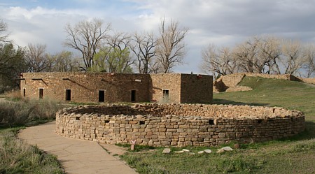
West
Ruin, the largest Great House at Aztec, consisted of over 400 adjoining rooms and
kivas, and rose to three stories. The carefully planned and built community includes
unexcavated pueblos, great kivas, tri-walled structures, earthworks, and many small
structures. Relationships, orientations, and placement of the structures suggests
overall planning was adhered to during the centuries of building and occupation.

Above, a portion of the long north wall of West Ruin.

Several t-shaped doors open onto the plaza from West Room pueblo.

View of the reconstructed West Ruin Great Kiva from the northwest.
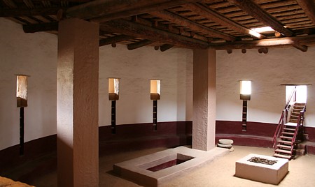
Interior views of the Great Kiva.


Several upper rooms feature diagonal doorways in the northeast section of the ruins.

The east wing of West Ruin viewing across the plaza from the west wing.
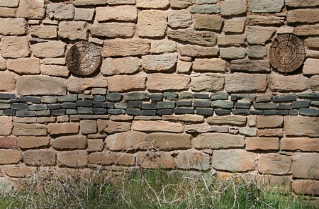
Several bands of green sandstone are a unique feature at Aztec Ruins.

The museum features artifacts from archaeological excavations.
| Aztec Ruin Great Kiva |
azrgk |
36.835038 |
-107.999507
|
| Aztec Tri-Wall Kiva |
aztwk |
36.836097 |
-108.000444 |
Aztec Ruins PowerPoint Presentation = 3MB download

During the summer of 2009, I completed more
Aztec GPS readings.
Additional comments are added to the Chaco Meridian page.
| Aztec West Ruin Great Kiva
|
awrgk
|
36.8350280
|
-107.9995010
|
GPS 2m, mean of 6
|
| Aztec East Ruin Great Kiva
|
aergk
|
36.8356073
|
-107.9970025
|
GPS 2m, mean of 11
|
| Aztec Hubbard Tri-Wall Kiva
|
ahtwk
|
36.83611111
|
-108.00043056
|
GPS 2m, mean of 2
|
| Aztec Ruin F Tri-Wall Kiva
|
aftwk
|
36.83595556
|
-107.99852222
|
GPS 2m, mean of 5
|
Aztec Ruins Placemarks for Google Earth - 15 KB KML file.
External Links
|


