|
Southwest Archaeology Lecture Notes
© 1998 by James Q.
Jacobs
Anthropology fields are: Socio-cultural, Linguistics, Physical anthropology,
and Archaeology. Archaeology is the study of anthropology in the past.
To a great extent archaeology depends on cultural remains.
The American Southwest cultural area defined: From Durango Mexico to
Durango, Colorado and from Las Vegas, Nevada to Las Vegas, New Mexico.
All of Arizona, Southern Utah and Colorado, and most of New Mexico.
Distinguishing features are diverse topography, aridity, simple technology.
Geographic/Cultural subdivisions are Puebloan, Rancherias and Athapaskans.
Athapaskans arrived about 500 years B.P.
Pueblos have multiple languages and ethnic groups. Pueblo means "village."
The pueblos are the oldest continuously inhabited settlements in the
United States. Western Pueblos are the Hopi and the Zuni. The majority,
the Eastern Pueblos, are in the Rio Grande Valley. Prehistoric Puebloans
were agriculturalists and hunters and gathers. Eastern Pueblos do irrigation.
Unifying features of Puebloans are clan organization, adult initiation
into societies, shared world view with this as the fourth world, sipapu
is the place of emergence from the underworld, ritual structures called
kivas have a sipapu. Katchinas in one conception are seen as ancestral
spirits that bring rain. Katchina dances encourage the katchinas to
arrive, ceremonies conducted in kivas and plazas.
Rancherias are a dispersed settlement pattern over several miles instead
of a concentrated village. Many ethnic groups are included in the rancheria
area. These include the Pima, Tohono O'odham and related languages.
One Pima group is the Gila River Reservation. Pima lived on or around
major rivers and were sedentary, 60% farming dependent, using tepary,
beans, squash and corn. Tohono O'odham migrated with the seasons using
two settlements and were 25% farming dependent. Both organized into
local groups and these groups endured for centuries, surviving longer
than the actual villages.
Philosophy of Archaeology.
Use of material culture to gather information. Context provides the
basis for understanding items. Excavation is destructive, therefore
the archaeologist has a responsibility to preserve material, collect
data and record findings. Research design: 1. Pose a significant question,
2. Plan how to answer the question, 3. Design a research strategy to
gather evidence sought, 4. gather the evidence, excavate, do laboratory
work and write the results.
Dividing up the Southwest. In Social Sciences we need categories/systematics.
Major SW areas are: Puebloan, Mogollon, Hohokam. These are archaeological
names, not actual ancient cultures. Red-on-Bluff People was an early
category for the Hohokam.
History of Archaeology in the Southwest
1539 Fray Marcos de Niza visits Zuni. This is the first recorded contact.
1540 Coronado expedition reached Zuni, the Tiwa pueblos. First written
history in the Southwest.
1800's Euroamericans question who the Indians are. Evidence of civilization
prompted assumptions of help from other "civilizations."
Direct Historic Approach (1870 - 1910)
Richard Wetherill discovers cliff dweller sites like Mesa Verde.
John Wesley Powell, Smithsonian Bureau of American Ethnology, begins
salvage archaeology, collection as much information as possible.
Stevenson Expedition to Zuni in 1897 collected information and objects,
wrote an encyclopedic volume. For the first time data was collected
with objects.
Frank Hamilton Cushing, part of the Stevenson Expedition, lived at Zuni,
went native and was adopted into a Zuni society, spoke their language.
Adolph Bandolier was in Cochiti in 1880. Studied and mapped ruins, including
Pueblo Grande.
Chronology and Classification (1910 - 1960)
Systematic data collection begins and classification schemes are proposed.
1926 - Folsom site is discovered. Points in an extinct bison altered
the temporal paradigm.
Kroeber and Spier (1916 - 1917) developed the seriation method based
on pottery remains.
A. V. Kidder, the first ever Ph. D. in archaeology, (1915 - 1929) conducted
the first stratigraphic excavations of middens at Pecos Pueblo.
1927 - Kidder organized the Pecos Conference. Basketmaker and Pueblo
periods defined by the Pecos Classification.
1915 - Department of Anthropology at University of Arizona. Arizona
State Museum founded.
1937 - Douglass founds the Laboratory of Tree Ring Research at U of
A.
1928 - Museum of Northern Arizona founded.
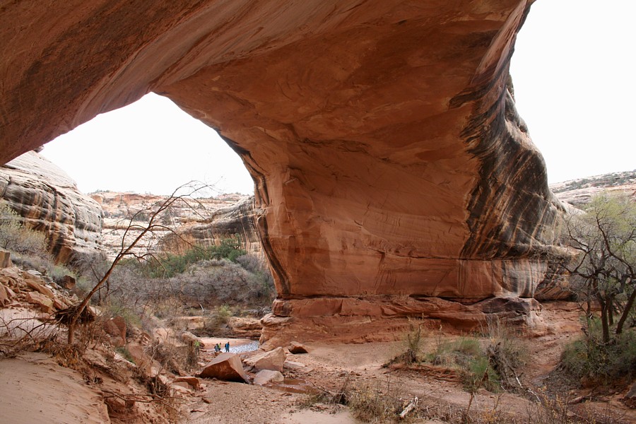
Pecos
Pueblo Ruins.
Processal Archaeology (1960 on)
Louis Binford wanted archaeologists to develop general laws of cultural
processes. He saw the SW as a vast natural laboratory.
Cultural Resource Management
1974 - Archaeological Resource Protection Act passed. Some large projects
have been Roosevelt, Black Mesa. Caused a large change in what is studied
and provided a great increase in the financial expenditures on archaeology.
1990 - NAGPRA - cultural affiliation rights, agencies had to list items
held, tribes could make claim, scientific and humanistic evidence valid.
The Southwest Environment
Key factors are rainfall, temperature, number of frost free days, farmland
availability, water sources, floodwater.
Plant categories: wild and domesticated. Domesticated plants appear
in the SW by 1500 B.C.
Domesticated are genetically altered and dependent, to some extent,
on human propagation.
Cultivated are the same genetically as wild, tough planted and cared
for by humans. Agave.
Hohokam Region: Sonoran advantage- lush desert with wild food
plants year around; spring wild barley, agave, cholla buds -- summer
saguaro fruits -- fall and winter mesquite, acorns, prickly pear. Cultigens
are agave. Farming of corn, various beans, squash, gourds, supported
by large-scale irrigation on flood plains. Fauna of rabbits and fish,
small game.
Mogollon Region: Forests rich in plants but not in human foods,
diverse wild resources are cacti, mesquite, piñon,
acorns, but not abundant. Farming of small patches of arable land by
rainfall and floodwater farming. Mimbres used floodplain irrigation.
Weather often not ideal, wet and cool or warm and dry. Population smaller
than Pueblo or Hohokam areas.
Pueblo Region: Less diverse wild resources, arable land varies
by area with growing season problems in some areas. Farming was by floodwater,
rainfall and irrigation in some areas.

Cultural Periods
Paleo Indian Culture -- 11,500 - 8,000 BP poorly dated tentative
epoch. Monte Verde, Chile, 13,400 BP row houses with numerous remains,
Channel Islands, 13,000 BP skeleton, Meadowcroft, PA, 14,000 - 17,000?
BP, Tlapacoya Island, MX, 24,000 BP hearth.
Highly mobile, little time depth to sites, little revisitation, low
population density, high quality rock tools, manuported rocks, possible
broad social networks. Technology of fluted points, atlatls, rare ground
stone in Ventana Cave, Arizona. Lehner Ranch in So. AZ an important
site, extinct mammals and Clovis points. Clovis sites in North America
from Alaska to Panama. Folsom points have a larger flute, are shorter
and not as widely distributed (SW only). Folsom 11,300 - 9,000 (8,000)
BP, Clovis 11,500 - 9,000 BP
Archaic Period -- 8,000 - 1,800 BP. Altitherm was 7,000 - 4,500
BP. More regionalism of cultures with diverse projectile point traditions,
side-notched, corner-notched, and barbed points, evidence varying hunting
strategies. Broad spectrum adaptation to small game and plant resources,
esp. rabbits and seeds. Technology includes digging sticks, serrated
stone, ground stones, manos and metates, storage baskets. Yields fruit
3k - 9k cal/hr, nuts 1k - 2k cal/hr, seeds 200 - 600 cal/hr. Tome and
space scheduling requires intense knowledge of landscape. Residential
and logistical mobility.
Early domestication of plants evidence in SW:
Tornillo 3225 BP, Mogollon Desert in SW NM
Bat Cave 3441 BP, West NM
Three Fir Shelter 3040 BP, Colorado Plateau
Milagro 2780 BP, Sonoran Desert near Tucson associated with pithouses.
Early domesticates spread quickly. Late Archaic (1500 - 200 BC) had
corn, gourds and squash, associated with pithouses. Earliest sedentary
farmers are in the Sonoran Desert. Slow change to sedentism is attributed
to cultural evolution and genetic evolution. Sedentism = living year
around in one place.
Basketmaker II -- 200 BC - 500 AD, major changes. Pithouses
associated with residential seasonal mobility, multi-year use. Multi-year
middens, more burials.
Basketmaker III -- 500 - 700 AD. Beans and pottery, bow and
arrow, smaller points indicate new adaptations. Pottery = less mobility.
Beans (lysine) = complete protein. Pottery used to cook beans = maximized
caloric return. More storage pits and cists. Pithouses more substantial
and great kivas appear.
Comparing Basketmaker III sites:
-Shabik'aschee had a communal economy: 70 small, standardized pit houses
with small antechambers suitable for two persons, 47 cists, few storage
pits in houses, large great kiva, storage and caching visible to community,
burials outside pithouses.
-SU site had a household based economy: 35 large, variably sized, larger
antechambered pit houses, one large pithouse, storage inside homes and
less visible, diverse burials.
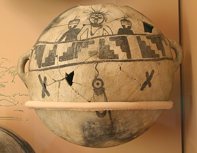
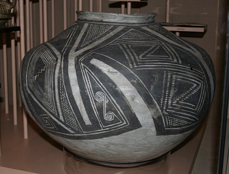
Pottery is ceramic, a chemical compound incorporating metal
and non-metals. Earthenware is low temperature fired and porous. Stoneware
is high fired and non-porous. Porcelain is vitrified (glass) and translucent.
In the Upper Paleolithic in the Old World ceramic figurines occur around
13,000 BP Jomon pottery (in Japan) occurs between 10,000 and 5500 BC.
Hohokam around 200 AD. Components are basic materials, clay, temper
to stop cracking, increase thermal shock resistance, increase porosity.
Temper is useful to archaeologists in identifying provenience of ware.
Forming of pots is a culturally identifiable process. Mogollon and Pueblo
pots are coiled and scraped. Hohokam and Sinagua coiled and formed on
a anvil using a paddle. SW pots are made without molds and without throwing.
Decoration included polish, slip, paint, appliqué, or corrugated. Firing
was done in the open or in lined pits, using wasters as cover.
Pueblo I -- 700 - 900 AD. Year round occupation in pueblos with
above ground rooms, some pit houses, pit structures have some ritual
features. Typical site a double row of rooms fronted by pit structures,
winter use of pits. Structures are warm and cold adapted. Living rooms
have storage rooms attached. Household based economies and less sharing.
Field houses indicate claim to land areas. Plant remains support continuous,
year round occupation. Painted pottery, both black and white, and red.
Duckfoot, a hamlet, relative dating based on bonding and abutting of
construction. McPhee village has 21 room blocks and a remote kiva. 800
AD 2 great kivas 22.5 m in diameter. 840 - 900 AD oversized pit structures
- 5 m - central in room blocks with elaborate sipapus and footdrums.
Late 800's abandonment with pit structures burned, burying bodies in
the floor.
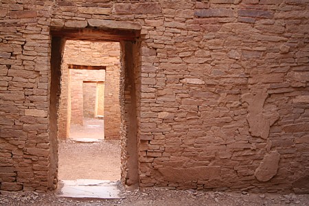
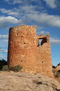
Pueblo II -- 900 - 1100 AD. Dominated by Chaco Canyon. First
large scale stone ruins in the US. 850 Pueblo Bonito Phase, 900 irrigation
agriculture, 1150 Great Kiva phase.
Chaco Era 850 - 1150. Chaco sequence begins around 850 at confluence
of drainages with good access to water and agriculture sites. 1000 -
1100 major population growth, Chaco considered a major regional center
by 1050. 1075 - 1115 major construction peak. 1088-1092 Beams brought
from 50 miles distance. 1100's experience environmental changes. 1130
- 1180 was a period of reduced rainfall. Around 1140 to 1150 Chaco became
depopulated. Aztec Ruin takes place of Chaco. Chaco population estimated
at 1500 - 5000. Given room with hearth is a habitation = six people,
therefore 1500 - 2000 people. Given a room suite = six people 1500 -
2000, with Bonito at only 150 residents.
Lots of non-habitation architecture, with a chain of storage rooms at
Pueblo Bonito, and rooms deep within structure. Road related rooms at
Pueblo Alto.
Architecture: Room average is 44 tons of sandstone, 50 million
pieces in Chetro Ketl. To construct all the great houses 200,000 trees
were used. Bonito had 4-5 stories and 600 or more rooms. Over engineering
meant easy upkeep, inference of cultural importance. Estimate of a stage
of construction was 30 people x 2 - 4 months a year for 10 years. Great
houses built in stages. Chaco kivas can be above ground and surrounded
by rectangular walls. Cribbed roofs. Great kivas are 15 - 20 meters
in diameter. Casa Rinconada 63 feet.
Pueblo Alto is one story 85 rooms with a big plaza. 1020 - 1060 construction,
maintained until 1100. Only 5 household suites, these are heavily worn.
Big room suites are not heavily worn and have a kiva. Trash midden is
2400 m3 with 150,000 pots, evidencing feasting.
Status is evidenced at Chaco. A few burials are very rich, elaborate
and early in the sequence. Little evidence of private wealth and residential
evidence is of equality. Chaco health is better than at small sites.
Acquired status likelier than stratification of the society.
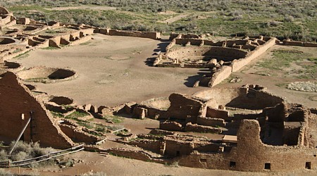
The Chaco System: Chaco regional system of about 100 sites in
an area of 100,000 km2. Outliers have some Chacoan characteristics:
multistory structures (great houses) great kivas, raised, enclosed kivas.
Roads estimate is 2400 km.+ symbolic link roads point to Chaco. Imports
to Chaco are pottery, 50% in 1000's and 95% in 1120. Shell, turquoise
and deer imported. Processed turquoise exported.
Chacoan outlier/great houses identified: Dating from A.D. 900 - 1115
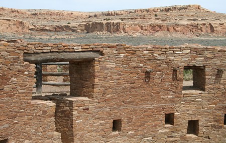
Architecture: unprecedented and unequaled massive size and planning,
period specific horizontally aligned, carefully coursed masonry patterns,
walls stronger than at other Puebloan structures, over engineering, advanced
architectural planning, large scale and grand design is unique;. Buildings
are taller, walls are thicker, stone pattern more intricate, rooms larger
than typical Puebloan constructs. Many storage rooms in the Chaco Canyon
great houses. Outliers have multi-story structures. Great kivas or raised
enclosed kivas, kivas in great houses above ground and enclosed in surrounding
rectangular walls. Cribbed roofs laid on bench
Roads are carefully engineered and flanked by berms of adobe,
stone or earth, often connecting the great houses.
Pottery: Cylinder vessels found exclusively at Chaco great houses,
black on white painted vessel.
Turquoise trade in evidence, processed turquoise items.
Organization. Chaco Canyon is seen as a center for the regional
system. The number of storage rooms may have been for redistribution
purposes. The sites with outlier great houses are seen as part of the
regional system. These populations utilized the canyon sites for gatherings.
The center may also have served as a trade center. Roads often connected
the sites. The region was tied together around Chaco Canyon. With Chaco
Canyon acting as a ritual center and trade center. The low number of
residents in Chaco Canyon would indicate that the visitors to the canyon
came from the outliers.
Archaeologists see evidence for a direct relationship with Chaco Canyon
culture through the over-engineered architecture; the core and veneer
walls; great round kivas surrounded by a square wall; like design and
technology in pottery styles; multi-story structures; an inordinate
number of non-habitation rooms; and often these outliers were connected
by the Chaco roads.
Chacoan Great Houses identified by: --core and veneer masonry, over
engineered
walls; round kivas w/square outside walls built above ground; lot of
extra non-habitation rooms, multistory, plazas part of pueblo layout,
often a great kiva incorporated, roads to/from Chaco --large quantities
of pottery from the Chuska Mountains to the west; turquoise found at
outliers same as found in Chaco, traceable roads connecting outliers
and Chaco.
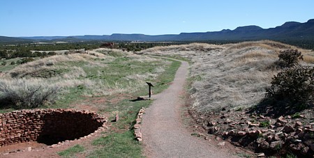
Casa
Riconada, with Chetro Ketl in the background.
Pueblo III -- 1100 - 1300
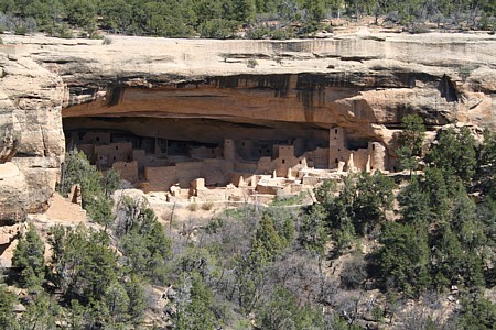
Mesa Verde (4-Corners, San Juan) Region. History: 1888 Richard Wetherill
finds Cliff Palace, 200 rooms, 8 kivas and 8 levels, turkey pens. Mesa
Verde had largest aggregation in SW after 1150.
1889-1900 1000 visitors, instant fame, Wetherills began trading antiquities.
1893 Nordenskiold "The Cliff Dwellers of Mesa Verde," excavated in Mug
House and Spruce Tree House.
1906 Antiquities Act, Mesa Verde National Park. 1908 Fewkes restorations
of Sun, Fire Temples
Mesa Verde Sequence: Mesa top habitation on Chapin and Wetherill
Mesas. 36 sites with 200 - 400 people AD 1000 - 1200. Tower construction.
Mummy Lake Reservoir held 500,000 gallons. 1200 AD shift to canyon occupation
with greater aggregations. Fewkes Canyon had 33 sites with 530 rooms,
600 - 800 people, Sun Temple, Cliff Palace and Spruce Tree House built.
Sun Temple has bi-walled construction.
Montezuma Valley: 10,000 - 30,000 people doing Mesa Top dry
land
farming. 1000 - 1150 population dispersed. 1200 population aggregated
into 8+ towns, some with history and some new. Important communities
established by 1000 with community stability and mobile people. Pre-1150
household occupations 15 - 25 years, post 1150 - 1250 25 - 50 years.
Evidence of conflict onset around 1200, upon aggregation into towns.
Standardized ceramic complex in the region with no imports. Isolation
from the remainder of the SW. No imports in evidence by 1300. Sand Canyon
Pueblo: 1250 - 1280, canyon rim site, east side residential and west
side with kivas, unit pueblos, low encircling wall, use of boundary
marking stones.
Mesa Verde Region Abandonment Process. 10,000 - 30,000 people
leave the region. People moved to the Rio Grande and Little Colorado
River areas. By 1200 more concentration into central Mesa Verde region
with abandonment of small sites as people aggregated in towns. At Sand
Canyon orderly abandonment evidenced. Units of movement parallel unit
construction. Trash filled units indicate process over several years.
Some units burned with contents, kivas burned.
Abandonment causes. Migration is a normal event for SW populations.
Great Drought from 1276 - 1299. 1275 tree ring dates, complete abandonment
by 1300. Not the first drought event in the SW. Carrying capacity of
the land. People were in circumscribed areas. No evidence of invading
outsiders. Evidence of intra-regional conflict with some people getting
killed at some sites. Attraction of the riverine sites. Irrigation terraces
on the Little Colorado, reliable irrigation on the Rio Grande.
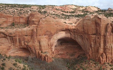
Kayenta Region: Black Mesa, Canyon de Chelly, Long Valley, Tsegi
Canyon. No Chaco outliers during Pueblo II. Black Mesa empty by 1150.
Tsegi Phase: 1250 Keet Seel founded, 1267 Betatakin founded. 1272 -
1276 population influx with new sites. 1280 population maximum. 1285
decline, 1300 deserted. Room cluster construction w/o kivas. Clusters
of storage, living, granary and courtyard. Betatakin has 135 rooms,
2 kivas, homogeneous architecture built in 3 organized phases with pre-cut
beams. Kite Seel has 155 rooms and 6 kivas with more variable construction
and accretion of buildings. New organization evidenced with fewer kivas
not linked to household units. Long House Valley had five clusters of
sites with the focal site at the water source, 2 - 12 satellites. intervisibility
of major sites may have been defensive.
Pueblo IV: post 1300
Pan SW processes and styles. Hohokam and pueblo distinction is blurred.
Larger sites and clusters of sites with open regions between clusters.
Plazas incorporated into pueblos with fewer kivas. Pueblo III had six
rooms per kiva, Pueblo IV has 50 : 1 ratio and end of unit pueblos.
Cotton is grown as a commodity. Conflict is evidenced.
West pueblos are matrilineal descent groups with ritual societies that
cross-cut descent groups, absence of architectural boundaries.
Katchina
iconography (Fourmile Style) appears. Southwest regional iconography
on pottery, rock art and kiva murals; flowers, butterflies, serpents,
parrots, masks.
Homol'ovi pueblos: Little Colorado River near Winslow. 1276 river entrenched
freeing 5,000 HA of terraces. In migration, no katchinas, cotton growing,
little local pottery:
Homol'ovi III linear constructions, 40 rooms, 2 rectangular kivas, sandstone/adobe,
Tusayan pottery. Homol'ovi IV terrace-like and masonry construction,
150 - 200 small rooms, White Mountain and Cibola pottery.
1300 AD river rises again and Homol'ovi III and Homol'ovi IV abandoned.
Aggregation and mixing in the new Homol'ovi I and Homol'ovi II pueblos,
with much larger, plaza-oriented sites, Katchina iconography, lots of
cotton, Jeddito Yellow Pottery, Fourmile Style, shrines, field houses
and territoriality marking. 1400 abandonment and move to Hopi villages.
Comparison and contrast: Pueblo III (1100 - 1300) versus Pueblo
IV (post 1300)
Architecture: PIII - self-contained unit pueblos with one kiva
to every 6 rooms, great kivas, more dispersed on the landscape. PIV
- no more unit pueblos, ratio of 50 rooms to a kiva, rooms in rows,
larger planned construction events, plaza oriented sites, defensible
building planning, much larger pueblos (5 - 10 times larger) and (discrete
spatial clusters) open regions between concentrations of pueblos. Advent
of the marking of land and territoriality.
Interpretation: Conflicts and resource competition by larger populations
resulted in aggregation of the population in defensible, larger communities.
Plaza architecture is defensive. Discrete spatial clusters of pueblos
are interpreted as evidence of distinct polities and hostility.
Agriculture: PIII - Subsistence agriculture of corn, beans and
squash. PIV - Introduction of cotton. Interpretation: Trade and exchange
have gained in importance. PIII agriculture was almost exclusively food
production. During PIV cotton becomes ubiquitous, new commodity production
becomes new economic activity, producing possible wealth.
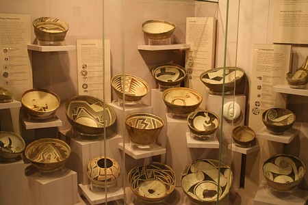
Pottery, Art and Iconography. PIII - Regional styles in pottery,
standardized ceramic complex with little importations, no katchinas.
PIV - pan-SW processes and styles, Hohokam and Puebloan distinction is
blurred. Advent of Katchinas, Four Mile horizon style with themes of
fertility (flowers, butterflies, masks, serpents), terraces. Change
in decorative patterns on painted ceramics. Interpretation: Time of
change and/or turmoil, possible conflicts. Promotion of a sense of community.
Social changes.
PIII had clustering of regional pottery styles and minor exchange. PIV
had pan-SW styles (Salado Polychrome) and high levels of trade, regional
interaction among groups increased significantly. PIII architecture
was unidirectional pueblos, small and lots of them. PIV used plazas,
compounds, surrounding walls, larger clustered sites, implication is
village aggregation to defensible locations infers conflict.
There are several lines of evidence for conflict in the post-1300 northern
Southwest. A variety of characteristics connect the prehistoric and
present indigenous populations: contiguous architecture, kivas, maize,
bean and squash agriculture and ritual beliefs and practices focused
on katchinas. To date most studies have placed greater emphasis on the
similarities of historic Pueblo culture and the late prehistoric. Abandonment
of traditional territories and transformation of the social landscape
contradicts the paradigm of substantial cultural continuity. Focus on
the differences will allow a better understanding of the cultural changes.
In order to understand modifications in village architecture the social
context of the period must be examined more closely. The social context
of the thirteenth to fifteenth century was characterized as much by
conflict as by cooperation. Changing settlement size (communities five
to ten times larger than late thirteenth century towns), the change
from great kivas to plaza-oriented architecture and changes in decorative
patterns on painted ceramics evidence social changes in the fourteenth
century. Aggregation in the late thirteenth century is seen as due to
defense and safety in numbers, with the threat of conflict continuing
in the fourteenth century. Plaza architecture is interpreted as defensive.
Discrete spatial clusters of pueblos are interpreted as evidence of
distinct polities and hostility. A major indicator of conflict was the
aggregation of small, unidirectionally designed pueblos into large,
walled clusters with much greater distances separating the groups. The
use of walled plazas itself as a defensive tactic was attested to by
various Spanish explorers. Placing the clusters further apart reduced
the competition for arable land.
Mogollon
Distinguishing features include coiled and scraped pottery. Round,
then square, pithouses with ramp entry. Ceremonial structures lack sipapus.
Mogollon Sequence:
--Early Pithouse: 200 - 550 AD. High ground, lots of wild foods. Pottery:
brown, then red slip, then painted.
--Late Pithouse: 550 - 1000 AD. Large sites near flood plains, more
farming. Pottery: white slip, eventually B/W.
--Classic: 1000 - 1130/50 AD. pueblos and irrigation. Pottery: elaborate
B/W, naturalistic and abstract designs. Classic Period was one of intensive
farming of corn, beans and squash, water control features, bordered
fields with ditches and terraces, low tech and labor intensive.
Mimbres area in 1100 AD had lots of riparian species and mesquite, and
by 1150 mostly bushy plants. Trees had been cut. Villages of 50 - 200
rooms and field houses. Continuous occupation for hundreds of years.
Clusters of rooms gradually expanded as population grows. Environmental
degradation corresponds to growth. Organization: no apparent plan to
villages, no hierarchy evidence, homogeneous architecture, rules of
painting pottery. By 1150 the villages had been abandoned. Movement
is an important aspect of desert adaptation. Residential stability results
in local environment degradation. Non-sustainable.
Postclassic: 1150 - 1250. Reorganization in Rio Grande drainages.
Continuity evidence is remodeling and additions, ceramics - classic
Mimbres pots in use, radiocarbon dating is flat. Also new social relationships
in evidence: new pots, new ceramic ware types, up to 8 vs. one. New
technology added to plainware evidences some immigrations.
Comparison and contrast of the Mimbres Classic and Postclassic occupations.
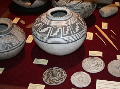
Pottery -- Classic; 1000-1150, elaborate black on white, naturalistic
and abstract pattern, homogeneous style with apparent rules of painting.
Iconographic conventions include many rabbits, sheep, copulation, unusual
animals, humans, masks, mesoamerican themes and plumed serpents. --
Postclassic; 1150 -1250, Classic Mimbres pots in use in Postclassic.
Mimbres iconography discontinued. New technology added to plainware.
A diverse variety of pottery types associated with different areas of
the Southwest at Postclassic hamlets. Classic Mimbres iconography is
continued after 1150. Reserve-Tularosa technological style imported.
Interpretation of the evidence: Ideology of conformity during the Classic.
New technology indicates influx of some new people. Regional interaction
increased post 1150 with greater social interaction and movement of
people.
Settlement patterns -- Classic; pueblos, villages of 50 to 200
rooms and field houses. Hundreds of years of continuous occupation.
Autonomous clusters of rooms with no apparent plan to villages and an
amorphous plaza. Homogeneous architecture. Environmental degradation
evidenced by deforestation, firewood evidence. Concentrated population
in the Mimbres Valley with field houses. AD 1000 lots of riparian species
and mesquite, 1150 AD mostly bushy plants. -- Postclassic; villages
abandoned or heavily depopulated. Change from villages to small hamlets,
remodeling and additions to Classic period field houses with transformation
of jacal into masonry. Radiocarbon dating supports continuous occupation.
Mimbres style architecture continues. Interpretation of the evidence:
-- Classic; clustering of rooms indicates gradual expansion of population.
no evidence of hierarchy, residential stability, residential stability
was a non-sustainable subsistence pattern. -- Postclassic; remodeling
of field houses indicates continuity, Flat radiocarbon date indicate
continuity.
Agricultural practices -- Classic; irrigation systems were in
use, water control features, bordered fields with ditched and terraces,
low tech and labor intensive, intense farming of corn and beans. --
Postclassic; All hearths had cultigens, change from large scale irrigation
systems to dispersed. Interpretation of the evidence: There was a degradation
of the environment from long and continuous use. Cultigen evidence indicates
same manner of subsistence, with change in areas farmed. General interpretation:
Mimbres classical abandonment was actually a reorganization. Community
and regional relations were redefined at a broader and less restrictive
level.
Mimbres Classic period was marked by aggregated villages with several
hundred inhabitants.
Postclassic saw population disbursement to small hamlets.
A breakdown in social structure, and land degradation could be reasons
for abandonment of Classic villages. Classic period pottery has distinct
and ubiquitous iconography. Iconography does not appear in Postclassic
contexts. Therefore, social control/organization does not appear to
exist, or weakens considerably, after 1150. There is a high ubiquity
of cultigens in Mimbres Classic period hearths. There are cultigens
found in 100% of all Post-classic hearths studied
Therefore, it would seem that Postclassic Mimbres are still cultivating
at least as much as the Classic Mimbres.
Discussion: Ways in which the focus, or scale of observation, affect
our understanding of prehistoric 'abandonments' with reference to the
Mimbres and Mesa Verde 'abandonments.' Focusing only on a small area
may give the impression that a region has been abandoned. The Mimbres
valley may have been abandoned, but the Mimbres region evidences continuity
of occupation. In this case a regional view is adequate to assess what
really occurred. In the case of the Mesa Verde abandonment a much wider
view is needed. The Mesa Verde populations did abandon the region and
moved to the Rio Grande Valley, a movement of greater distance than
the Mimbres. The Mesa Verde movement can be called an abandonment, the
Mimbres is best viewed as a regional reorganization. A camera viewfinder
is an excellent analogy because a number of push and pull factors may
lead a population away from an area that they had historically occupied.
In the camera example, a narrow focus of the camera would indicate that
the area was abandoned and the inhabitants disappeared, when in fact
they had just moved out of the view of the camera. In the case of the
Mimbres, the population did not abandon the region, signaling the end
of the Mimbres culture. Rather they disbursed to smaller hamlets to
the east. If we do not expand our scale of observation it would be easy
to assume that they had disappeared. The scale of observation needs
to be larger for the Mesa Verde region. Its inhabitants moved all the
way to the Rio Grande Valley 200 miles distant.
The following commentary on this document regarding the Mimbres material
was provided by Dr. Harry J. Shafer of the Department of Anthropology
at Texas A&M University:
Mimbre architecture: There are at least six different functional types
of rooms, and the occurrence of these functional types depends on the
size of the social group, and whether it is an extended family or corporate
group. Features in rooms and the way they articulate with other
rooms defines the room type. There is a great deal of variability
in the use of building materials, depending on the location relative
to the kind of available stone, and when the room was constructed. Great
kivas during the pithouse-pueblo transition (A.D. 900-1000) had sipapus,
and Classic corporate kivas had rectangular floor vaults placed next
to the hearth.
Mimbres mortuary practices: Intramural burials, which account
for 85% of all Classic period burials, were lineage cemeteries placed
beneath certain types of rooms. Extramural burials included inhumations
(10%) and cremations (5%).
Mimbres pottery: Style III painted pottery ceased to be produced probably
before A.D.1150. Arguments for continued use after 1150,
are based on radiocarbon dates. A microstylistic sequence worked
out for Style III based on tree-ring dates indicates the rules of design
began to break down after A.D. 1100. Style II and III were but
one of a number of material correlates that relate to the organization
of Mimbres society involved in irrigation agriculture. When the
system broke down after A.D. 1130, the pottery ceased to be made but
heirloom vessels may have been used up to mid century.
For more complete information and some excellent graphics visit
Mimbres
Archaeology.
Hohokam
The Hohokam are multi-lingual and multi-ethnic; ancestral to O'odham
and Yumans. 1400's population was 40,000 to 80,000. Spanish contact
population was 5,000. Area is from Gulf of California to Flagstaff,
core area was Gila-Salt confluence and adjacent valley areas.
Traits: rancherias (houses in pits), irrigation agriculture with
large scale canals, red on bluff, paddle and anvil pottery, naturalistic
figures in the designs, cremation, links to Mesoamerica as evidenced
by ballcourts and platform mounds, social hierarchy.
Chronology: Origins show continuity from the Archaic or earlier,
Dating difficult due to lack of dendrochronology, before 1980 less than
120 dates, now thousands.
Preclassic: Pioneer -- 300 BC - AD 500. Colonial -- 500 - 875. Sedentary
-- 875 - 1100/1150. Classic: 1150 - 1450.
Subsistence: Flowing rivers and Sonoran abundance. Farming included
floodplain, ak-chin, dry terraces, canals. Canal irrigation by the end
of the Pioneer period included the main canals and laterals totaling
500+ miles, farming 25,000 acres. Canals were up to 50 - 75 feet wide.
Method is risky, expensive and highly productive, and requires organization
of labor. Silting evidenced at La Ciudad. Soils salinization evidenced.
Floods damaged the system. Disease vectors increase.
Architecture: Pit houses had risers in early Pioneer period,
evidencing in-house storage. Risers decline with advent of courtyard
groups. Courtyard groups occupied 40 - 100 years. Ballcourt from Tucson
area to Flagstaff, with 225 ballcourts at 160 larger sites. Oval, elliptical
in form with berms.
Trade: Regional exchange network larger than ballcourt area.
Gulf of California shell homogeneous distribution, copper bells and
exotic stone from Mexico, obsidian from Gila Bend area, forest products
and stone from the north. Valley had a surplus of agricultural product.
Temporal Changes: Adobe compounds replace pit houses during Classic.
Hohokam redware changes from Gila Red (to 1300) to Salt Red evidencing
change in exchange. During the Classic platform mounds replace ballcourts
and are concentrated. One mound replaces several ballcourts, indication
of social reorganization. 1250 AD residences atop mounds. 1300 Salado
polychromes imported and increase of activity in the Tonto Basin. Inhumation
increases. New iconography.
Canals and Social Organization: Canals require headgates, specific
gradients, cannot cross waterways. Management is necessary. Hohokam
system increased in complexity over time. No evidence of violence indicates
social stability. Largest sites at the headwater of the canal. Often
one major platform mound near the headwater of the canal. The larger
upstream canals lasted longer. Steeper gradients in the Classic may
indicate water competition.
Hierarchy: Greatest evidence of hierarchy in the SW. Few Great
Houses and limited number of mounds indicates regional organization.
Special houses and goods found atop mounds. Walled compounds around
mounds and Great Houses. More adobe compounds near mounds with courtyard
groups ion mound periphery.
Roosevelt Platform Mound Study: Unlike Phoenix, area has more
intact archaeology. Mounds had no cooking pots. In 1280 rooms infilled
and new story added. No hearths in rooms and little food refuse. Platform
mounds had ceremonial rooms, with some rooms around the mound having
hearths. Rare objects, crystals, stone balls, shell trumpets. Gila Polychrome
era 1320 AD: Cline Terrace: 2-3 m. high mounds, 2 m. wide surrounding
compound wall. A dozen ceremonial rooms, lesser surrounding sites w/o
central economic focus. Turquoise evenly distributed. Dentition study
indicates close relationship of Phoenix populations to Tonto Basin settlers.
Tonto Basin had a dozen platform mounds and hundreds of villages.
Comparison: Pre-Classic Hohokam ballcourts and Classic platform
mounds.
--225 ballcourts at 160 of the largest sites, 40% in the Phoenix basin
(compared to thousands of Hohokam sites)
- ballcourts are oval or elliptical form depressions surrounded by berms.
- ballcourts were dispersed across the Hohokam regional system
- ballcourts were accessible to the entire community
--platform mounds are concentrated, within 60 miles of Snaketown (Lower
Gila River), there are fewer mounds than ballcourts.
- mounds are built of solid fill with stone or adobe exterior retaining
walls
- mounds had rooms built on them after 1250
- mounds had courtyards and enclosure walls. These may have served to
limit access.
Similarities: Both ballcourts and platform mounds were ceremonial
in nature, both were constructed as public works; both mounds and ballcourts
acted as unifying elements within the culture; both probably facilitated
trade. Exchange and interaction is similar and continued from the pre-classic
to the classic period,
Differences: Residences were built on platform mounds; ballcourts
were built throughout Hohokam regional system, while platform mounds
were concentrated in Phoenix, Salt River, Gila River and southern Arizona.
Ballcourts were accessible to everyone, but the mounds were occupied
by only a few individuals. Mounds more labor intensive to construct;
Mounds seemed to service village clusters, while ballcourts were distributed
in most villages. Ballcourts were phased out and platform mounds became
more prevalent. Society moving toward greater complexity. Centralized
powerful leadership emerged
Interpretation: The mounds and ballcourts are interpreted as
indicating a shared cosmology and ritual pattern. Different communities
gathered together at ballcourts and at platform mounds, with more centralization
at the later. The scale of social, political and ritual organization
shifted to larger units with a hierarchy. The society evolved from simple
to more complex. The mounds and ballcourts were constructed as public
works; both mounds and ballcourts acted as unifying elements within
the culture; both probably facilitated trade;
ballcourts were accessible to everyone, but the mounds were occupied
by only a few individuals; ballcourts were phased out and platform mounds
became more prevalent;
society moving toward complexity and a centralized powerful leadership
emerged
Temporal Patterns without Temporal Variation:
Hohokam chronology depends on ceramics variation. Classic period red-slipped
ware makes up 10 to 30 percent of Hohokam ceramics between A.D. 100
and 1450. These have been the basis of site dating. Schroeder divided
redware into Gila and Salt, and he designated Gila Red as the temporal
diagnostic for the first part of the Classic and Salt Red was assigned
to the later Civano phase. In Schroeder's model one type replaced another
throughout the Phoenix basin. Later authors divide the ware into four
types and retained the model of change in the creation of ceramics by
a unified pottery tradition over time.
The excavation of parts of Pueblo Grande changed this view. The temporal
trends previously noted and assumed to be temporal trends over time
were shown to be production differences across space. The regional scale
analysis that was performed in conjunction with the large Pueblo Grande
excavation included petrographic analysis. Close association between
clay and temper types was proven. Hohokam potters relied on materials
closest at hand, therefore temper is an excellent indicator of production
areas. Sand types have determined six production zones in the Phoenix
Basin.
At Pueblo Grande 3,300 redware sherds were identified by temper type.
The results indicate the degree to which Hohokam villages relied on
other villages for red ware. The change in red ware is a change in sources
of an imported commodity, not a temporal variation in how potters produced
local ware. The variation at work is the way populations in the region
interacted with each other. Widespread patterns of exchange and interaction
are in evidence.
Comparison and contrast: Sedentary Hohokam and Chacoan regional
systems:
-- Agriculture: The Hohokam relied on a river source irrigation system
and an extensive system of canals. The Chacoans relied on rainfall and
collecting runoff for irrigation. Both cultures used irrigation systems
to facilitate agriculture. The Hohokam used massive irrigation canals
to bring water to their large fields. This resulted in significant surpluses.
The Chacoans used check dams and diversion/collection systems but were
reliant on water pouring into the canyon from the rim after thunderstorms.
The perennial water advantage of the Hohokam allowed the population
to grow significantly.
-- Architecture: The Chacoans built massive and over engineered great
houses. The Hohokam built numerous large ballcourts and then many platform
mounds. Both cultures had an emphasis on public works. The Hohokam at
first invested community time in constructing ballcourts and later,
platform mounds and great houses that required a large and devoted work
force to spend valuable time on non-life-giving ventures. The Chacoans
spent even more effort on massive public works. The over engineering
in Chaco Canyon, the cribbed roof kivas, the roads all point to large
community efforts. Both societies benefited from surplus of labor directed
towards public works
-- Social Organization: The Chacoan system had a concentrated central
system of great houses. The Hohokam had dispersed platform mounds. Both
the Chacoans and the Hohokam evidence some hierarchy or at least high
status individuals. Elite burials are found in Chaco Canyon and cylinder
mugs are only found in association with the canyon great houses. The
burials in association with the canyon great houses were in better health
than the average Puebloan. The Hohokam hierarchy is evidenced by limited
access to the platform mounds and residences on the mounds after 1250.
Hohokam distribution of shell artifacts was homogeneous throughout the
ballcourt region. In Chaco the majority of shell seems to be found in
Chaco canyon, as imports from the outliers. Chaco system had a less
even balance of precious goods.
These notes are my writing, and were taken during an undergraduate course in Southwest Archaeology at Arizona State University taught by Dr. Michele Hegmon. I am solely responsible for the transcription. |