| Mound Builders of the Eastern Woodlands 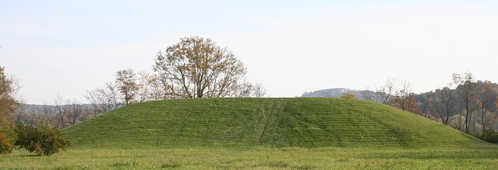 |
| Archaeology
of the Scioto River Sites |
|
Scioto River Sites in South Ohio Oct. 19, 2005 I arrived in Ohio today after driving across Kentucky, enjoying the Fall colors all the way. Last evening I was standing atop "Temple Mound" at Towosahgy State Historic Site (http://www.mostateparks.com/towosahgy.htm). Sunset was a brilliant red orb due to heavy field burning by Mississippi bottom farmers. The full moon rose on the opposite horizon just as red. I took two GPS readings. The so-called Temple Mound is 36.6949167 degrees N., 89.235083 degrees W. The site is presumably protected by the state, but the tractor driver brush-whacking the weeds drove up and down the steep conic mound near "Temple Mound", eroding the slope, dragging dirt about and leaving tire impressions. Sometimes the protectors do the most harm! After leaving the Ozarks, my first stop was Lilbourn, MO. The local police officer was very helpful. I waved her down while driving through Main Street. She didn't know where Lilbourn Mound was, but she hailed someone who did, Larry Lewis. On his quad, Larry led me from town to the mound and we had a great visit as I took readings. Lilbourn is at 36.57194 N. and 89.58825 W. The site is now a high school, a field, roads, and a cemetery. They quit planting people atop the mound a decade after the last Indian war. Lilbourn Mound, Lilbourn, Missouri
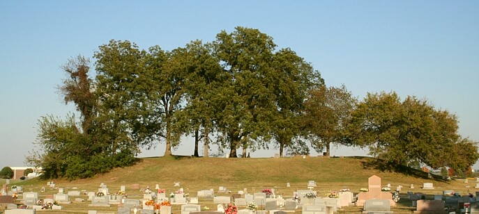
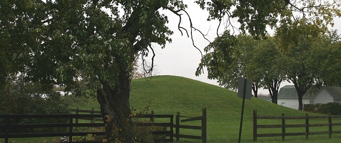
Portsmouth, Ohio My first Ohio stop was Portsmouth, near the mouth of the archaeology-rich Scioto River. In Mound Park, Horseshoe Mound, one of two reported in the 1800's, remains of a complex of earthworks spanning both sides of the Ohio River. Possibly, another major mound is topped by a nearby building, to the east of the horseshoe mound. The following image views the mound from the south.
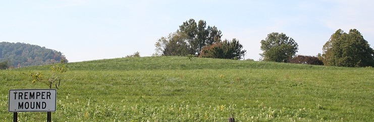
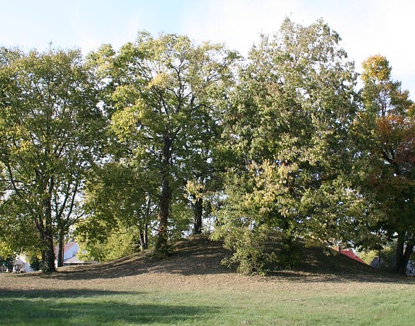
Oct. 20, 2005 Today was another awesome Fall day in Ohio, with temps in the 80s. The Fall colors are supreme. Brilliant red maples adorn the hills. Here follows an image of Tremper Mound, north of Portsmouth and across the Scioto River. A 200' x 100' building site, as evidenced by about 600 post molds, was covered by the mound's construction. Curiously, the Portsmouth Horseshoe Mound and Tremper Mound are at about the same elevation. Coincidence? My WAAS-enabled GPS was providing 5m accuracy in 3D from about 6-8 satellites.
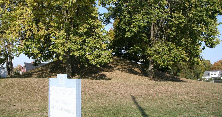
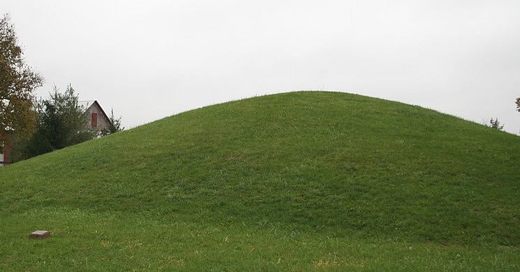
I started my day late after organizing a bit. Seal Earthworks, a site now destroyed by more than a century of cultivation, was impossible to see. I took several GPS readings of landmarks that will be visible in aerial photography. A portion of the works are faintly visible in old aerial photos. Combining old images and modern readings may place position the now invisible earthwork. A useful survey and drawing exists in Squier and Davis’s 1848 classic Ancient Monuments of the Mississippi Valley published by the Smithsonian Institution. Seal Square, or another portion of the works, apparently runs directly under the house Gilbert Fisher was working on, so I got to meet a really great Ohioan interested in prehistory. His kind permission allowed me to wander about the property. Gilbert was painting siding, and I was as impressed by the perfectly straight lines in his construction work as I am of the straight Hopewell earthwork lines. Seeing earthworks had to wait until I was further upriver. I moved north up the Scioto Valley to Chillicothe and the surrounding concentration of earthworks. In Chillicothe, Story Mound still survives amidst residences. The 25 feet high (now 19) by 95 feet wide at the base mound is considered Adena, the archaeological culture preceding the Hopewell.
Story Mound State Memorial
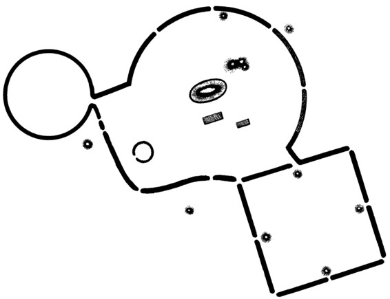
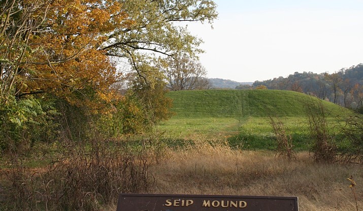
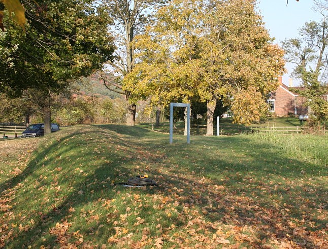
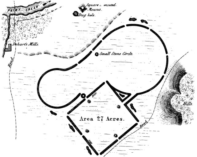
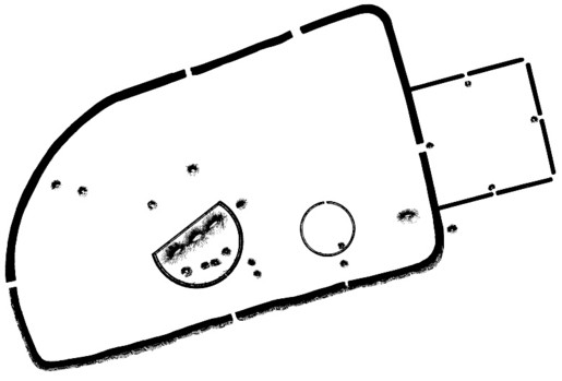
Seip Earthworks From Chillicothe, I drove west out Paint Creek Valley to Seip Mound and Seip Earthworks. Seip Mound is one of the largest mounds at 250' x 150' x 30' high. Most of the earthworks surrounding the mound are nearly destroyed, again by long agricultural cultivation. At Seip, the over 10,000 feet of earthen berms or "walls" were about 50' wide and 10' high. Now that's a lot of baskets of dirt to move by hand. The following drawing is based on the Squier and Davis survey drawing, as are my other earthwork outline drawings to follow.
A small portion of the walls remain clearly visible, thanks to the fact they were in the barnyard instead of the plowed fields! They are nonetheless greatly diminished in size from treading and wear. In the view following from atop the mound, some sense of the size of the earthworks can be appreciated. The mound is near the center of the over 1500' in diameter circle, the second largest of the known Hopewell circles. You can see the remaining portion of the circle near my auto. The second image following also records a GPS location atop the embankment (visible in the foreground).
Baum Earthworks
My last stop of the day was nearby Baum Earthworks, another site obliterated by agriculture. The image above is one of Squier and Davis's original drawings. Paul Dunn and his kind family welcomed me onto their land and allowed me to wander about taking readings, again of landmarks visible from the air, such as property corners and boundaries. Paul reports that a large mound within the corn field, now quite flattened, was excavated in the 1880s. This mound is likely the one depicted as a square, truncated mound in the Squier and Davis drawing. Like Gilbert, Paul possesses a wealth of information about local prehistory. The local citizens are both kind and knowledgeable. It might be difficult to farm along Paint Creek or the Scioto River without becoming an amateur archaeologist! It's late on the East Coast, and time to rest.
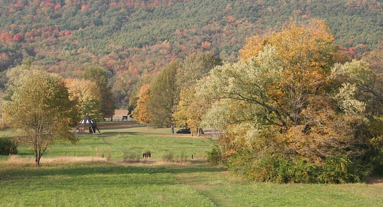
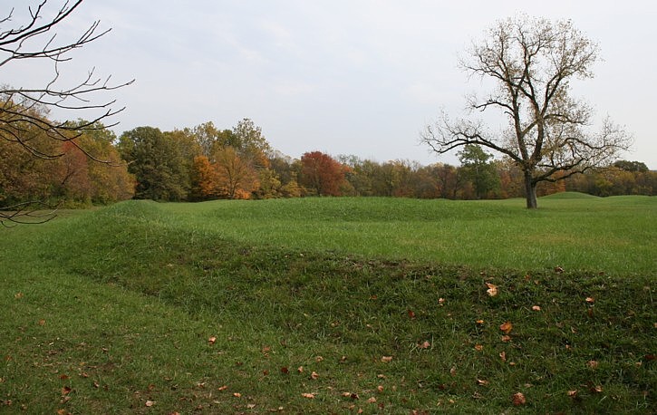
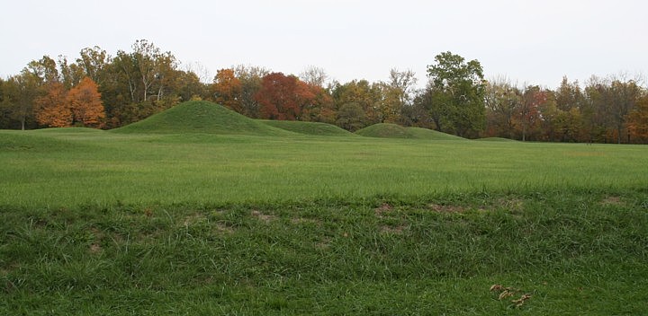
Oct. 21, 2005 Mound City Group, Hopewell Culture National Historical Park Inside an earthen enclosure over 2000 feet wide, a concentration of burial mounds yielded a wealth of artifacts when excavated. Mound City Group is one of several ancient earthworks now owned by the National Park Service. The next image views the enclosure wall and several mounds from the NW corner, looking east. The second image views Central Mound, the tallest mound, from the SW corner. The corners of the enclosure walls are somewhat rounded.
Unlike all the other locals, the NPS was less than helpful. Because I might "cause erosion," I could only walk to the top of Central Mound IF I filled out two pages of paper requesting a special use permit, submitted my research design for review and approval, and met with the Park superintendent for an interview, a process that would have taken most of my working day. Rules are rules, I'm told. I tried to take GPS from around the mound, but the mound blocked the differential correction satellite, so I ran out of battery power. I'll have to average readings to place this feature. At least NPS isn't plowing the place! All the hassles broke my schedule for the day. More information and some excellent readings on the Hopewell
Culture are found at the NPS site:
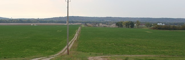
Hopeton Earthworks Located across the Scioto river from Mound City, Hopeton Earthworks is another of the geometric earthworks that the Hopewell Culture is so noted for. It consists of a 900' square and attached 1050' circle according to the Squier and Davis drawing, albeit they appear to be near equal in size. Romain has the dimensions at 957' and 960' respectively. Given a century of plowing, at best the size is fuzzy now. In the following photo you can see one of the square's embankments, the low rise in the field, and several excavation trenches transecting that embankment. While many of the works are now invisible or nearly so due to agricultural plowing or town plotting, Hopeton is discernable in most places. The square alone extends out of this image on the right. Parallel embankments extended from the work towards the Scioto river and Mound City. The large circle is located to the right, and encroaches on the north square wall. A smaller circle encroaches on the square east wall in the right foreground. Note the gravel plant near the river.
Although the skies turned gray, I was spared a soaking above the knees today.
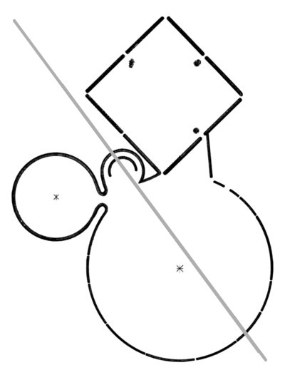
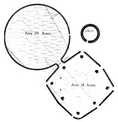
Liberty Earthwork My last site of the day was Liberty Earthwork, south of Chillicothe across from the mouth of Paint Creek. Liberty consisted of a square and three circles, plus a large internal mound known as Harness Mound (not shown in my drawing below). None of the features are visible today. A highway runs through the site, as indicated by the gray line. Liberty Earthworks features the largest of the Hopewell circles at 1720' in diameter, enclosing 40 acres. Like some other squares, Liberty Square measures 1040' per side according to Squier and Davis. Again, a very kind farmer, Robert Harness, took time to assist me, indicating the original location of Harness Mound and discussing other useful information and directions I needed. I'm beginning to think all these farmers are archaeologists. I'm really impressed with their knowledge of the Hopewell and the earthworks. Mr. Harness knows Dr. Carr, my instructor for the Hopewell seminar at Arizona State University where I created some of the drawings herein.
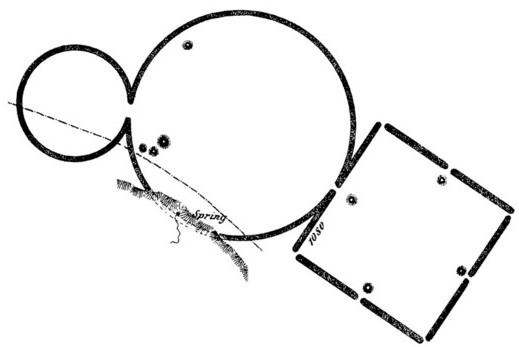
Oct. 21, 2005. Last night, I arrived late in Frankfort after closing the college library in Chillicothe. I car camped below a beautiful stained glass window at a Frankfort church, then got an early start. Frankfort is a beautiful town with great old architecture, a testament to the rich farmland in the local bottoms. As you see in the photos, the weather has changed here in Ohio, with Indian summer turning to Oregon winter. I like rain for chanterelles and morels, but not for photography. Frankfort Earthwork The modern town of Frankfort is located on the site of the former earthwork. Thanks to its size, one feature escaped destruction, Henneberger Mound. The Henneberger family preserved the mound and donated it to the Nature Conservancy in honor of Freda Henneberger, hence the recent renaming. Frankfort Circle was one of the largest of the Hopewell circles.
Hopewell Earthwork
My next stop was nearby Hopewell Earthworks, namesake for the archaeological culture. The enclosure is massive, as was the central mound, three interconnected mounds measuring about 500' by 180' by over 30' high. Squier and Davis surveyed the large enclosure at 111 acres, the square at 10 acres. They rated this square as 850' across. Shetrone measured the enclosure at 115 acres, the square at 16.5 acres. Hopewell Earthwork was recently acquired by NPS, so better size data should follow. I encountered two U. of Illinois archaeologists doing contract work for NPS, preparing for site interpretation. An interpretive path will wind around the site and through a woods where the embankments are well preserved. I took several GPS readings and moved on, to another recent acquisition by NPS, High Bank Earthwork.
High Bank Earthwork
High Bank is barely discernable today, so no photography. This site, also recently acquired by NPS, remains undeveloped. Fortunately, the site was accurately surveyed over a century ago. High Bank has one of the two (or three) octagon works created by the Hopewell. Also, one of the two circles known to be very precise true circles is found here. The other is the circle attached to the Newark Octagon. Squier and Davis considered the possibility that the Hopewell used a standard measure. Several researchers have presented their hypothetical Hopewell units of measure based on the repetition of dimensions in the earthworks. Marshall (1979) asserted Hopewell use of a standard of measure, the 57 m unit proposed for Teotihuacán, Mexico, by Rene Millón. Horn and Hively, in Hopewellian Geometry and Astronomy at High Bank, refer to the High Bank circle diameter as the High Bank Diameter (HBD). They rate the HBD at 320.6 m (1051 feet, 10 inches). The Newark Octagon Circle has a diameter of 321.3 m. Based on James Middleton's 1887 survey reported in Thomas, Hively and Horn computed eight octagon vertices distances at High Bank from 322.8 to 317.1 m with a probable accuracy of ±1 m. The overall length of the High Bank Earthwork is double the circle's diameter. Romain considers measures from 1,032 feet to 1,074 feet to be less accuracy expressions of this unit.
Circleville Earthwork, The modern town of Circleville was located with it's primary intersection, Main St. and Court St., centered on two large concentric circles, 1190 feet and 1056 feet in diameter. The streets align as the attached 1188 foot square aligned, with an alley running through its breaks. Needless to say, the ancient earthworks are now obliterated, but their former locations are known. I entered town just after midday to find a great festival in progress, the Circleville Pumpkin Festival. I've never seen such huge pumpkins, over 800 pounds! And the festival takes place all around the intersection of Main and Court. Pumpkins are, of course, native American cultigens. It seemed so fitting to celebrate pumpkins inside the ancient earthworks. I suspect very few of the festival attendees know this archaeological history. I was worried about how to take GPS readings in intersections. No problem, the streets were a carnival filled with people, not cars. At the very center of Main and Court stood the Information booth, in the very spot I wanted to stand. I joked to the people, "Do you have roof access." They said yes and told me to go ahead. There as a steel ladder and hatch, so I climbed up and had the best view in town of the giant pumpkin display. I left them with the GPS reading, in case anyone lost amidst the pumpkins asks, "Where am I?" Circleville Circles, 39.601889N, 82.9451111W.
Home | Archaeology | Astronomy | Photo Galleries | Contact and Feedback |
© 2005 James Q. Jacobs. All Rights Reserved.
| Some Ohio Monuments References and Readings:
Hively, Ray, and Robert Horn 1982 Geometry and Astronomy in Prehistoric Ohio. Archaeoastronomy 4:S83-S20. Hively, Ray, and Robert Horn 1984 Hopewellian Geometry and Astronomy at High Bank. Archaeoastronomy 7:S85-S100. Lepper, Bradley T. 1995 Tracking Ohio’s Great Hopewell Road. Archaeology 48(6):52-56. Marshall, James A. 1979 Geometry of the Hopewell Earthworks. Early Man Spring:1-5. Marshall, James A. 1987 An Atlas of American Indian Geometry. Ohio Archaeologist 37(2):36-48. Marshall, James A. 1992 Azimuths of Prehistoric Circle Openings and Parallel Walls of Easter North America Examined for Astronomical Orientation. American Astronomical Society. 5 June 1992. Mills, William C. 1914 Archaeological Atlas of Ohio. The Ohio State Archaeological and Historical Society. Moorehead, Warren K. 1922 The Hopewell Mound Group of Ohio. Field Museum of Natural History Anthropological Series Volume VI, Number 5. Chicago. Morgan, William N. Prehistoric Architecture in the Eastern United States. The MIT Press, Cambridge, Mass. Romain, William F. 2000 Mysteries of the Hopewell. The University of Akron Press. Squier, Ephriam G. and Edwin H. Davis 1847 Ancient Monuments of the Mississippi Valley. Smithsonian Institution, Washington, D. C. Thomas, Cyrus 1894 Report on the Mound Explorations of the Bureau of Ethnology. Twelfth Annual Report of the Bureau of Ethnology. Washington. Woodward, Susan L. and Jerry N. McDonald 1986 Indian Mounds of the Middle Ohio Valley. McDonald and Woodward, Blacksburg, Virginia (recent new edition available). |