|

2007.01.11 - Other
projects and research keep distracting from this writing, so I'm
posting terse results for now, in the Results and Observations table
below.
2007.01.16
- The builders at Thornborough have taught me a lesson, forcing me to
consider a new viewpoint on eclipses, the heliocentric perspective.
Lunar orbit and lunar phases are geocentric, so, as the earth and moon
orbit the sun, solar illumination rotates 360 degrees and there is one
less full moon cycle than lunar orbit per solar orbit. Both
heliocentric and geocentric motion ratios determine eclipse and lunar
phase periods, and heliocentric geometry underlies the mathematics. The
Thornborough results focused my attention on a specific arc module
underlying eclipses and provoked questions about builder knowledge and
archaeocosmology.
The Thornborough arc
distances focused my attention on a module, termed S22 for convenience,
defined as degrees solar orbit per lunar nodal period. To picture the
S22 module, imagine the series of lunar nodal crossings from the solar
perspective with the moon inscribing a wave pattern on the celestial
backdrop, steadfastly passing the earth and being passed in turn while
moving up and down, above and below the earth's plane of orbit, the
"ecliptic." S22 is a tick of the eclipse clock, the length of the lunar
nodal wave from heliocentric perspective, one of the two intervals
determining eclipses. The arc distance is earth's somewhat steadfast orbital
motion, the S22 module is defined by the mean arc per the moon recrossing the ecliptic.
Knowing about eclipse timing is one thing. Knowing how many degrees of
solar orbit motion a nodal period equates to is an entirely different,
advanced order of understanding. Evidence of the module implies
possible knowledge of the actual cosmology.
Previously, I introduced two
equivalent astrogeodetic modules, S27 and S29, in an Astronomy and Astronomical Modules
discussion. In quick summary, counting periods counts motion and I
employ the motion quantities in analyses. Study results pointed out the
S22 module (see results table below), due to the value's approxiation
to the S27 module.
Does the S22 module at
Thornborough evidence heliocentric knowledge? In ArchaeoGeodesy, I added an
eclipse calculator to facilitate this exploration. It uses the vlookup
feature; you type in the variable code from the adjoining list and the
calculator uses the correct value automatically. During the Neolithic, in Universal Time (UT1) the modules had the following values:
|
Module Code
|
Distance/Time, Degrees of
Orbit
|
Motion and Period
|
|
S22
|
26.820594
|
Solar orbit per lunar nodal
period
|
|
S27
|
26.928468
|
Solar orbit per lunar orbit
|
|
S29
|
29.105605
|
Solar orbit per lunar synodic
period
|
Selected Results and Observations
The site coordinates are
shown below and integrated in archaeogeodesy.xls
using the vlookup feature. You can input the site codes, such as
"thorn" for Thornborough North, and the application employs the
appropriate latitude and longitude. The calculator returns arc distance
in degrees, km, miles, radii, circumference, and astrogeodetic modules.
It also returns site-to-site bearings in degrees and displays
illumination declinations for solstices and lunar extrema using a
user-specified date. You can examine the cited relationships further
using the application.
|
Results
and Observations
Regarding the shorthand code, the
terms and values key is in the archaeogeodesy.xls
spreadsheet. The module noted at Thornborough is heliocentric and
eclipse related, S22 or degrees of earth orbit per nodal month. S22
represents the frequency of the lunar nodal period. S22 is angular
measure from heliocentric reference of the lunar nodal period on the
ecliptic ( = 26.82059°).
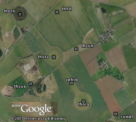
|
thorn - thors = 0.00050 S22
thorn - thorc = 0.00025 S22
thors - thorc = 0.00025 S22
|
thorc - nunhe = 0.0020 S22
thorn - thorc - nunhe = 179.96°
thorc - nunhe - devar3 = 179.92°
|
|
thorc - hashi arc =
0.02501 S22
thorc - hashi N-S = 0.02499 S22
|
humoh - rudmo =
0.02500 S22
humoh - hahib = 0.02498 S29
|
|
Devils Arrows and
Rudston Monolith
Two tallest menhirs in England
devar - rudmo = E-W line
devar - thorc = cir/2400
|
Silbury Hill and Marlborough Mound
Two largest mounds in Europe
silhi - marmo arc = cir/4800
silhi - marmo long E-W = cir/3000
|
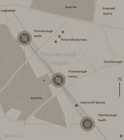
2007.07.07 - Newark Circle, the largest earthen
henge in the Americas, resembles the Thornborough henges. The arc
distance from Thornborough South to Newark Circle equals 2.0 S22. The
S22 spacing of the Thornborough henges repeats in the latitude and
longitude differences between Newark Circle and Newark Octagon (nocp). The arc
distance of the hypotenuse at Thornborough equals the latitude and
longitude differences at Newark (0.0005 S22). From Thornborough South,
the arc to Newark is 8,000 times the distance to the central henge.
Thornborough's lunar major
alignment is noteworthy. From Thornborough South, the lunar major
northerly set extrema aligns with the other henges. Assuming zero degrees
apparent altitude, the center-to-center line from the south to the
center henge matches lunar major during the epoch with 24 degee
obliquity, about 2758 BCE. At an altitude of about 0.82 degrees, the
north and south henges match the alignment. Between these two with altitude of zero, the lunar major alignment points to Ben Nevis, the
highest point on the British Isles. Given these initial findings, the
lunar extrema alignments may merit field study considering actual
horizon altitudes and other monument alignments.
2008.03.12
- Newark and Thornborough present similar evidence inferring geodetic
knowledge of their local latitude to longitude ratios. The Thornborough
North and Thornborough South henges form a 3:4:5 triangle and their
longitude difference in degrees equals their arc distance. The Octagon
to Newark Circle N-S and E-W degree differences are equal, and these
arcs are also equal to the Thornborough hypotenuse (data below). The
Octagon azimuth nearly matches the local latitude:longitude angle, and
one octagon side is an exact match. Reinforcing the inference on a
large scale, Newark Earthworks and Marietta
Earthworks, downstream at the Ohio River, are situated 1/365th the
circumference of the earth apart. Their longitude difference is equal,
also cir/365. (More discussion of Newark
and Marietta archaeogeodesy and archaeoastronomy.)
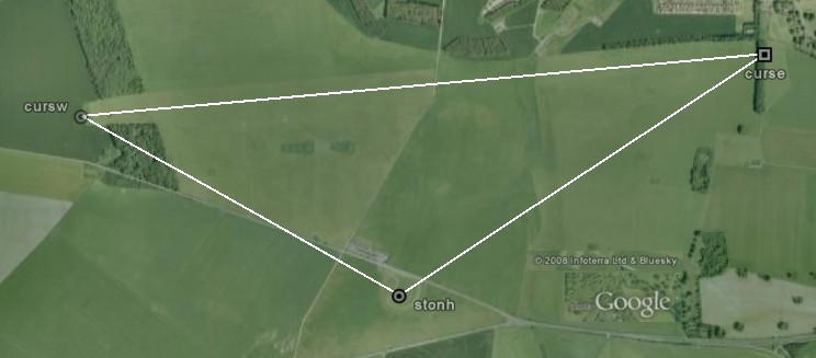
2008.06.12
- Thornborough presents the same arc distance as that from Stonehenge
to the West Cursus terminus. The arc distance from Stonehenge to the
Cursus W terminus (0.01336° = 0.00050 S22) matches the thorn-thors
spacing. More at:
Landscape
Geometry of the 'Cursus' and Stonehenge

ArchaeoBlog, an archaeology web log by
James Q. Jacobs
|
2007.01.14 - The Thornborough Page is
updated with a study results summary. The results caused me to
contemplate a new perspective on eclipses, a heliocentric model. In the
results, an eclipse related module termed S22 is prominent. S22, my AeGeo programming term for solar
orbit per lunar nodal period, equals 26.820613 degrees. We think of
eclipses from a geocentric perspective for the obvious reason. However,
eclipse frequency is a function of two motions, earth orbit of the sun
and lunar orbit of the earth. The planes of these two orbital motions
do not match, they incline 1/70th of a circle, sufficient to limit
eclipses to when full moons and new moons coincide with the moon
crossing the illumination plane of the earth. The lunar orbit nodes
with the ecliptic are the points where the moon crosses the earth's
orbit plane.
Full moons and new
moons are a geocentric phenomena. Except during lunar eclipses, half of
the moon is always lit by the sun. Lunar orbit around the earth
determines when we see the illuminated half. Earth's heliocentric orbit
factors in determining how often we have a full moon. If the earth were
stationary, of course each lunar orbit would equal one full moon cycle.
Instead, due to the earth and moon orbiting the sun, solar angle
changes 360 degrees each solar orbit, or one less full moon than lunar
orbits for each solar orbit. Heliocentric perspective is integral to
eclipse timing, and a heliocentric cosmovision underlies the geometry
and math. Knowing about eclipses and predicting their timing is one
thing. Knowing how many degrees in solar orbit a nodal period equates
to is an entirely different order of understanding. Regarding the
Thornborough builders, I wonder, "How much did they know, and when did
they know it?" And, "How precise was their knowledge?"
As I'm writing about
Thornborough and thinking about the past (and future) at the henges,
I'm wondering also if something important related to eclipses is going
on with geometry of the larger regional complex. Maybe the import of
the heliocentric perspective is all that escaped me. Eclipses are,
after all, the astronomer's cosmic clock, important at least from our
humble and fragile geocentric sphere. To ancient astronomers, all
counts and measure may have hinged on these precise displays of cosmic
geometry. For ancient geodesy,
lunar eclipses may have enabled accurate longitude finding, while half
the world briefly sees the same clock and each person sees the moon at
a different location in relation to the celestial backdrop.
In prose, what is S22?
Try to imagine from the solar perspective the frequency wave of lunar
nodal crossings, the moon inscribes the wave on the celestial backdrop,
passing the earth and being passed in turn, quickening and slowing
while moving up and down above and below the earth's orbit path. S22 is
a tick of the eclipse clock, the length of the moon's nodal wave from a
heliocentric perspective as the moon orbits us. Enjoy the surfing.
|
|
Further
Results and Observations
|
ncec - thors arc = 1.99999
S22 = 53.6410°
thorn - thors arc = 0.0005 S22 = 0.01347°
|
ncec - nocp N-S =
0.0005 S22 = 0.01366°
ncec - nocp E-W = 0.0005 S22 = 0.01319°
|
|
nocp - macam =
0.9863° = cir/364.995
nocp - macam E-W = 0.9864° = cir/364.963
|
Lunar orbit : Earth
rotation = 0.03650 : 1.0
|
|
2012.08.06 - A few deep decimal changes were made to this page while reviewing results with updated astronomy formulas and with Universal Time conversions. |
|
Thornborough
Henges, the Ure-Swale, and Surrounding Neolithic Monuments
|
|
Site
|
Longitude
|
Latitude
|
Coordinate Source
|
Code
|
|
Hasting Hill Enclosure
|
-1.44807
|
54.88031
|
English Heritage NMR
|
hashi
|
|
Hasting Hill Barrow
|
-1.45185
|
54.88353
|
magic.gov.uk 1:2,000
|
hahib
|
|
Dora's Seat
|
-2.17576
|
54.69388
|
magic.gov.uk 1:4,000
|
dorse
|
|
Devil's Stone
|
-2.08809
|
54.28770
|
magic.gov.uk 1:1,000
|
devst
|
|
Addlebrough Cairn
|
-2.08445
|
54.28873
|
magic.gov.uk 1:1,000
|
addca
|
|
Stony Raise Cairn
|
-2.07738
|
54.27792
|
magic.gov.uk 1:1,000
|
strac
|
|
Castle Dykes Henge
|
-2.02869
|
54.28116
|
English Heritage NMR
|
casdy
|
|
West Agra
|
-1.78305
|
54.23126
|
megalithic.co.uk
|
wagra
|
|
Catterick Henge
|
-1.64739
|
54.38148
|
English Heritage NMR
|
cathe
|
|
Great Crakehall Barrow
|
-1.62966
|
54.29875
|
magic.gov.uk 1:2,000
|
grcrb
|
|
Cowling Lane Round Barrow
|
-1.64059
|
54.29255
|
magic.gov.uk 1:2,000
|
colrb
|
|
Pickhill Moated Mound
|
-1.47046
|
54.24779
|
magic.gov.uk 1:4,000
|
pimom
|
|
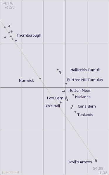
Three Hills Tumuli
|
-1.56347
|
54.21574
|
magic.gov.uk 1:2,000
|
thhit
|
|
Thornborough North A
|
-1.57137
|
54.21542
|
English Heritage NMR
|
thorn
|
|
Thornborough Cursus NE
|
-1.55930
|
54.21115
|
English Heritage NMR
|
thcun
|
|
Thornborough Centre B
|
-1.56409
|
54.21011
|
English Heritage NMR
|
thorc
|
|
Centre Hill Round Barrow
|
-1.56029
|
54.20692
|
magic.gov.uk 1:2,000
|
cehrb
|
|
Thornborough Cursus SW
|
-1.57100
|
54.20589
|
English Heritage NMR
|
thcus
|
|
Thornborough South C
|
-1.55768
|
54.20458
|
English Heritage NMR
|
thors
|
|
Rush Wood Tumulus
|
-1.55080
|
54.20306
|
magic.gov.uk 1:2,000
|
ruwot
|
|
Hallikelds Tumuli
|
-1.47387
|
54.17648
|
magic.gov.uk 1:2,000
|
hatu3
|
|
Hallikelds Tumuli
|
-1.47020
|
54.17454
|
magic.gov.uk 1:2,000
|
hatu2
|
|
Hallikelds Tumuli
|
-1.46856
|
54.17347
|
magic.gov.uk 1:2,000
|
hatu1
|
|
Nunwick Henge
|
-1.50691
|
54.16835
|
English Heritage NMR
|
nunhe
|
|
Burtree Hill Tumulus
|
-1.45866
|
54.16362
|
magic.gov.uk 1:2,000
|
buhit
|
|
Hutton Moor Henge
|
-1.46157
|
54.15638
|
English Heritage NMR
|
humoh
|
|
Hutton Moor Tumulus
|
-1.46463
|
54.15625
|
magic.gov.uk 1:2,000
|
humot
|
|
Harlands Plantation Barrow
|
-1.44569
|
54.15334
|
magic.gov.uk 1:2,000
|
haplb
|
|
Low Barn Tumulus
|
-1.45831
|
54.15127
|
magic.gov.uk 1:2,000
|
lobat
|
|
Low Barn Tumuli
|
-1.45898
|
54.14946
|
magic.gov.uk 1:2,000
|
lobat3
|
|
Low Barn Tumuli
|
-1.45653
|
54.14839
|
magic.gov.uk 1:2,000
|
lobat2
|
|
Blois Hall Round Barrow
|
-1.46864
|
54.14632
|
magic.gov.uk 1:2,000
|
blhrb
|
|
Cana Tumulus
|
-1.44696
|
54.14301
|
magic.gov.uk 1:1,000
|
cantu
|
|
Cana Barn Henge
|
-1.44921
|
54.14123
|
English Heritage NMR
|
cabah
|
|
Tenlands Henge
|
-1.44196
|
54.13769
|
English Heritage NMR
|
tenl
|
|
Devils Arrow N
|
-1.40408
|
54.09370
|
English Heritage NMR
|
devar2
|
|
Devils Arrow C
|
-1.40368
|
54.09319
|
English Heritage NMR
|
devar
|
|
Devils Arrow S
|
-1.40292
|
54.09229
|
English Heritage NMR
|
devar3
|
|
Yarnbury Henge
|
-1.98000
|
54.08464
|
magic.gov.uk 1:1,000
|
yarhe
|
|
Twelve Apostles
|
-1.80957
|
53.90160
|
magic.gov.uk 1:2,000
|
tweap
|
|
Newton Kyme Henge
|
-1.30250
|
53.89905
|
English Heritage NMR
|
newky
|
|
Ferrybridge Henge
|
-1.28232
|
53.71248
|
magic.gov.uk 1:5,000
|
ferhe
|
| Avebury |
-1.85407
|
51.44209
|
magic.gov.uk 1:5,000
|
avebu
|
| Silbury Hill |
-1.85745
|
51.41571
|
magic.gov.uk 1:5,000
|
silhi
|
| Marlborough Mound |
-1.73723
|
51.4166
|
magic.gov.uk 1:2,000
|
marmo |
| Mont Blanc |
6.86437
|
45.83255
|
cimes-et-sommets.net/gps
|
monbl
|
|
Ben Nevis
|
-5.00353
|
56.79685
|
magic.gov.uk 1:3,000
|
benne
|
2007.12.22
- Winter Solstice and Long Barrows
Astronomy Constants and the Avebury
Landscape? Perhaps
Thornborough Area Monuments: thornborough.xls | thornborough.kmz
Return
to: AchaeoBlog Home Page | Anthropology and Archaeology Pages
© 2007 by James Q. Jacobs. All
Rights Reserved. jqjacobs.net
|
Sources and
Further Readings
- AF Harding, with GE Lee 1987. Henge
monuments and related sites of Great Britain: air photographic evidence
and catalogue, BAR British series 175.
- Aubrey Burl 1993. From Carnac to
Callanish: the prehistoric stone rows and avenues of Britain, Ireland
and Brittany Dymond, DP 1963. The "henge" monuments at
Nunwick, near Ripon. 1961 excavation. The Yorkshire Archaeological
Journal 41:88-107.
- Harding, Jan The Neolithic
Monument Complex of Thornborough, North Yorkshire Maps and index to
site.
- Harding, Jan and Ben Johnson The
Mesolithic, Neolithic And Bronze Age Archaeology Of The Ure-Swale
Catchment, http://thornborough.ncl.ac.uk/reports/pubs_reports_ureswale/
See also: http://thornborough.ncl.ac.uk/
- Henges NMR Monument
Report, English Heritage March 9, 2006 (personal communication).
- Ruggles, CLN and AWR Whittle 1981. Astronomy
and Society in Britain during the Period 4000-1500 BC, BAR Series
vol 88.
- Thomas, N 1955. The Thornborough Circles,
near Ripon, North Riding. The Yorkshire Archaeological Journal
38:425-45.
- Vatcher, F. 1960. The Yorkshire Archaeological
Journal 40:169-182.
http://www.northernearth.co.uk/permgypsey.htmhttp://www.northernearth.co.uk/69haigh.htm
- Ladybridge Farm, North Yorkshire - The case
against quarrying. http://www.timewatch.org/Pages/LadyResp1.htm
- RESCUE's letter
of objection to the extension of quarrying.
|
|