|
|
|
Google Earth™ Placemarks
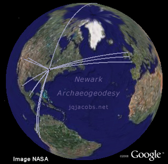
Below are collected some 2006 ArchaeoBlog entries related to creating the Ancient Monuments Placemarks, the archaeo/sites folder. As high resolution updates to the aerial imagery are made, I'm checking old and acquiring new ancient monument coordinates, and gaining new insights analyzing their relationships. New coordinates are now updated regularly in archaeogeodesy.xls. As I integrate Google Earth (GE) into my GIS research, more placemarks will use site codes from the spreadsheet. Eventually, I may build a KMZ file with the whole dataset. For now, the site list is still growing fast as more regions update with high resolution photos. |
|
|
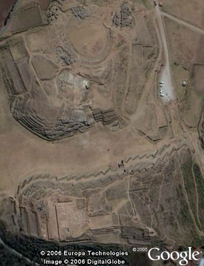
2006-11-27 - Cuzco imagery has finally been updated. Old Cuzco is unique, blending the fine Imperial or Classic Inca masonry walls, often as foundations, and colonial architecture and art. As the primary center of culture on the continent upon Contact, Cuzco is also very rich in monumental architecture, and was the centerpoint in a system of Inca monuments. The Tower atop Saxsayhuaman platform mound is clearly visible, and the zig-zag walls really stand out. I was surprised to notice a 100m long oval above the Saxsayhuaman Plaza, the same size as the Catequilla oval on the equator above Quito, Ecuador.
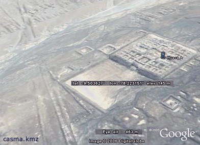
The Coricancha to Saxsayhuaman arc (R27/1000) is the same length as several other major monument spacings, including Avebury to Silbury Hill and Huaca Moxeke to Huaca A in the Casma valley. I noted other multiples of this arc in the Casma-Sechin complex. At Tiwanaku, the Akapana Mound to Puma Punku arc is two-thirds this distance (R27/1500), while at Chaco Canyon the arc from Chetro Ketl's great kiva to Pueblo Bonito's north great kiva is half the distance (R27/2000). From the Coricancha to the Moray circular monument, the arc equals 0.00500 radians. Travelers, we need GPS readings from all of these sites. Previously, using topographic map coordinates, I examined the relationships of the Chaco Canyon great pueblos. From GE imagery, acquisition of coordinates for specific features of the pueblos is now possible. While I'd prefer GPS and consider less accurate coordinates preliminary study, we can now examine the relationhips of the centerpoints of great kivas instead of just the great house relationships. The results have confirmed and exceeded expectations based on preliminary, map-based studies. I plan to add new Chaco Canyon findings to the Chaco Meridian page soon. Regarding Chaco results, I'll briefly state now that the relationships of the three largest Chaco kivas are of interest with respect to the scale of the earth. You can check both the arcs and the longitude differences of these, the Chetro Ketl, Pueblo Bonito, and Arroyo great kivas, using archaeogeodesy.xls. The coordinates are pre-programmed variables in this spherical trig spreadsheet; you simply input any of hundreds of terse site codes.
2006.11.07 - Machu Picchu and the Valley of the Incas Google Earth™ placemarks added. Aerial photography image updates in the Valley of the Incas region are enabling viewing more ruins and ancient trails, especially Machu Picchu, Ollantaytambo, and Inca trails and roads. This area still keeps many secrets of past activity in its rugged, often vertical, terrain. Enjoy following the Inca Trail and other trails and searching for more ruins. Unlike the local farmers, you won't have to worry about falling out of your field!
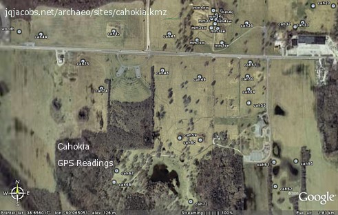
2006.11.03 - New placemarks files: Pyramids around Xi'an, China Placemarks and asia.xls. I want to address several concerns regarding Google Earth™ coordinate referencing and accuracy. I've applied a convention to designate these, for example "GE 2006.11.03" indicates coordinates sourced to Google Earth™ (GE) 2006, Nov. 3. The date sequence allows both alphabetic and chronological sorting, so I already apply this convention widely in file and applet version naming (and herein). Regarding accuracy, GE latitude and longitude may not be precise. As the online database updates, image locations can resolve differently than before. Therefore, I recommend applying the dating convention in referencing them, just as a reference to a web page should state the date accessed. To place reliance on accuracy, one can determine how accurate image overlays are for different areas of the digital globe and for different times. Some coordinates are quite precise. Most recent high resolution image updates will resolve very accurate coordinates. Note the accuracy of the Cahokia and Monks Mound imagery in relation to my GPS readings. Likewise, I've noted the accuracy of combining survey position, OS topographic maps, and GE at Stonehenge and other stone circles. Also, regarding accuracy, when viewing geometric monuments with significant elevation, the oblique views of the aerial images is readily apparent—just check the Washington Monument. In this GE screen capture of Khufu's and Khafre's pyramids, note the seam between two images (bright on the right and darker on the left) and note that each pyramid has a unique angle of oblique view. I locate the footprint centerpoint of large pyramids, rather than the highest point, to obtain a preliminary coordinate. This difference alone points to the degree of accuracy, or I should say "inaccuracy" of the monument representations in this format.
That said, I must add that Google Earth™ is a very useful GIS tool. GE coordinates use a global system. Any grid error for neighboring sites should be nearly equal (if updated at the same time). Plus, the monuments can be immense in relation to any inaccuracy, and the earth's circumference is a large measuring stick in relative comparison. GE coordinates are an improvement on old maps or, worse still, no location data. One last word, "Save your work." GE can use a lot of memory, and you might lose work you have not saved if the application does not quit in normal fashion. Creating placemark folders and saving them as kmz files backs up your GE placemarks.
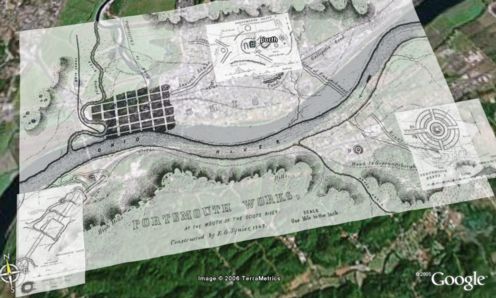
2006.10.27 - The Ancient Earthworks of Eastern North America pages include descriptions, photo
galleries, Squier and Davis and other early survey maps, and reports of
early explorations. I've integrated these resources with Google Earth™
placemarks. The maps are available as overlays in placemark files. The
individual placemarks feature both GPS readings and links to photos
taken at the location.
2006.10.18 - New placemarks for the Chicama-Moche Intervalley Canal. If you are impressed by large monuments, try to image the effort expended in building a 70 km canal, diverting a river from one valley to another—rather like building a 70 km long mound.
2006.10.15 - New placemarks and spreadsheet for the Thornborough Henges and the Ure-Swale Monuments: thornborough.kmz and thornborough.xls.
2006.10.12 - Updated spreadsheets: neolithic_calc.xls and archaeogeodesy.xls.
2006.10.06 - The new view in Google Earth of Woodhenge Circle clearly shows the part of the circle that survived the gravel quarry. The lagoon of stale water on the left was quarried. Monks Mound is to the east. Cahokia is a State Historic Site, a National Historic Landmark, and a World Heritage Site, yet the damage happened because the importance of the post moulds was not recognized. Thrice already today, sites I've tried to locate on Thornborough Moor have been destroyed by gravel quarrying. In these cases, unlike Woodhenge, nothing remains except the quarry pits.
2006.09.27 - Ancient Monuments Placemarks page added. As more areas of the earth are updated with high resolution images, Google Earth is becoming a useful archaeological tool. I started creating placemark files using coordinate data from ongoing studies. I've moved on to exploration, especially in the desert in Peru, where massive and very ancient ruins are particularly evident. Enjoy the files.
|
|
|
Return to the ArchaeoBlog Home | Archaeology | Astronomy | Photo Galleries | Contact and Feedback |


"Antiquity willfully veils the truth so
that the fool will go astray and only the wise may know."
Phaedrus, writer of fables, writing in Rome.
![]()