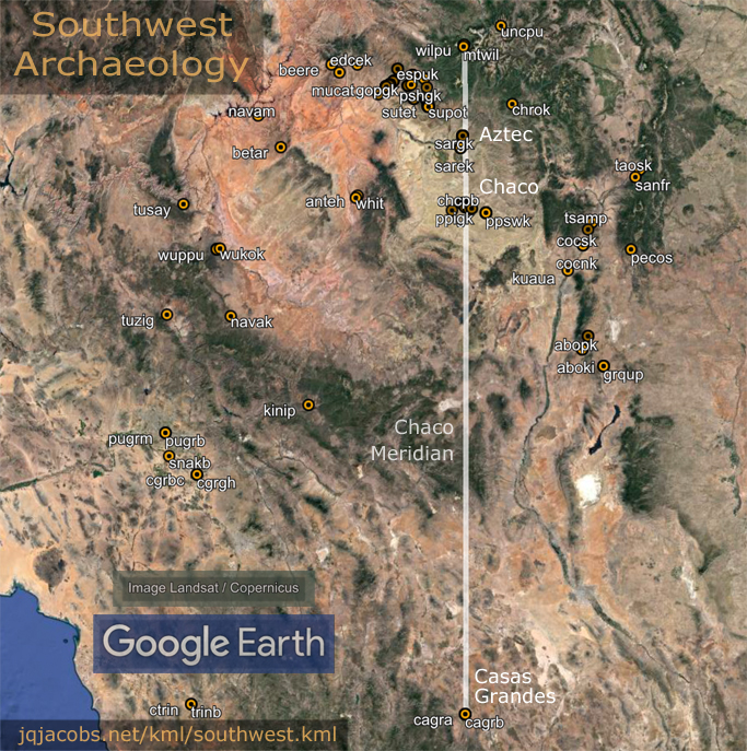
The Chaco Meridian
by James Q. Jacobs
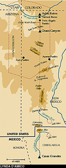
In February of 1990, I noticed that Big Horn Medicine Wheel, Aztec Pueblo, the Pueblos of Chaco Canyon, and the Mimbres Valley are all
situated on an approximate north-south line near the 108th meridian. I
informed the New Mexico State Archaeologist of the finding. This
observation was an outgrowth of my rock art fieldwork and, previous to
that, an interest in ancient astronomy as evidenced in
architecture. In the '80s, I had first noticed a group of rock
art sites with similar images on an approximate meridian.
Thereafter I began studying archaeology maps and mapping unmapped
archaeological sites. In 1991, I noticed that Casas Grandes, in
Northern Mexico, is on the same meridian as Chaco. Four major
cultural centers are concentrated on an approximate N-S line.
Meridians have been used historically to
determine the scale of the earth, so I gave the sites and meridian
further attention. Mt. Wilson, one of the highest peaks in the Rocky
Mountains, is also on the meridian. I named the concentration the
"Chaco Meridian" and noticed that the arc distance from Pueblo Bonito
to Wilson Peak precisely equals 1/200th of the circumference of the
earth, or 1.80 modern degrees. Likewise, of course, for the latitude
difference from Wilson Peak to Pueblo
Bonito and Chetro Ketl.
Chaco Canyon Great Houses - QuickTime movie - 282 MB
After observation of the meridional alignment
of these American Southwest sites, I examined other areas for other
arrangements. In February of 1991, I first noticed a meridional
concentration for the Dzibilchaltun observatory, Merida (prehistoric
Tiho), Sayil, Kihoic, Hormiguero, Uaxactun, Tikal, Las Tinajas, and El
Trapiche (Tazumal). I termed this longitudinal concentration the
"Maya Meridian." On March 21, 1991, while checking the distances
between Chac Mools, I noticed the 1/36 of circumference distance (10.0
degrees) from the Tenochtitlan pyramid to the Castillo pyramid at Chichen Itza (both have Chac
Mools in their interiors). I also noticed the Tikal to Chichen
Itza arc distance of 1/100 of circumference.
During Nov. 1991, to accurately check
site-to-site relationships at greater distances, I began using
spherical trigonometry. I discovered that the Newgrange-Cheops
arc equals 1/10th of circumference and the Newgrange-Avebury arc equals 1/100th
of circumference. These early findings prompted continued inquiries,
and more site relationships have since been noted. Some evidence
infers a relationship between the Chaco Meridian and the Maya
Meridian. A more detailed explanation of my concepts regarding
the relationship of ancient monuments to geodesy and geodesy-related
astronomy is found in the Archaeogeodesy
article series.

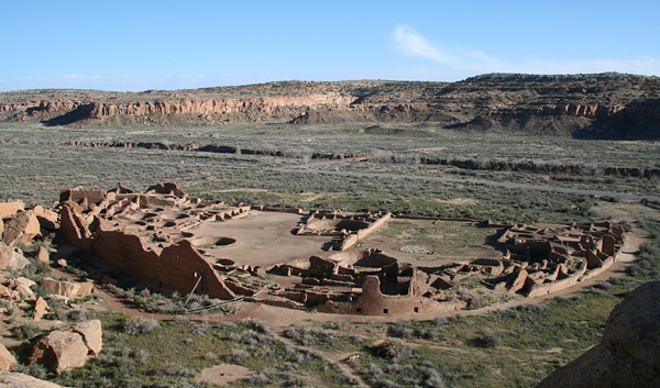
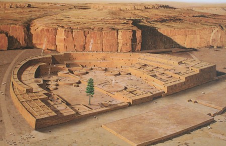
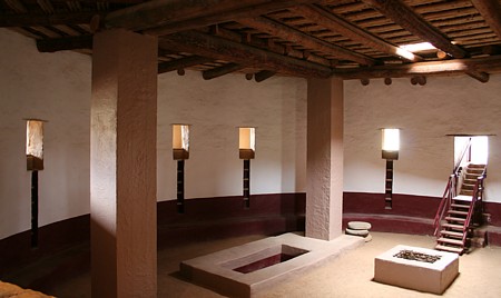
At Pueblo Bonito, the north-south alignment of
the central wall and the east-west alignment of half of the south side
are well known. In academic publications, the Chaco phenomena has been
a focus of careful astronomical study since publication of "A Unique Solar
Marking Construct" by Anna Sofaer, Volker Zinser, and Rolf M.
Sinclair (Science, 19 October 1979, 206:4416, 283-291). Sofaer,
et.al.'s Fajada Butte study demonstrated complex astronomy for both
Chaco Canyon and southwest rock art placement and epigraphy. The Fajada
Butte archaeoastronomy discovery focused my attention on southwest rock
art and on these authors for one of the first times. Fajada Butte is an
illumination hierophany on a small scale relative to Great House lines
and alignments the authors later considered.
Again in 1982 and 1983, Sofaer and others
published on "astronomical markings" and "lunar markings" on Fajada
Butte. Sofaer, Michael P. Marshall, and Rolf M. Sinclair noted the
relative longitudinal positions of major sites in their 1989
publication "The
Great North Road: a Cosmographic Expression of the Chaco Culture of New
Mexico" in World Archaeoastronomy, edited by A. F. Aveni,
New York: Cambridge University Press.
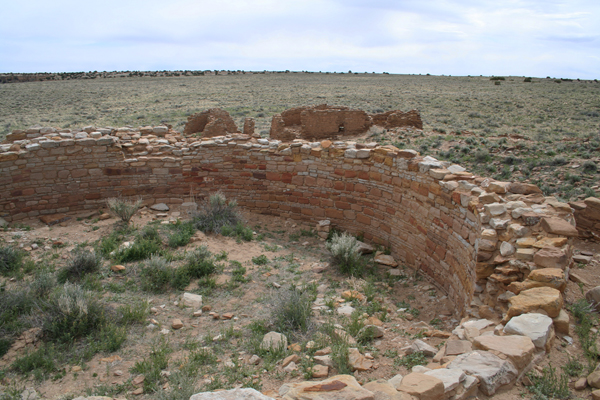
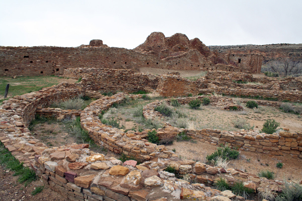
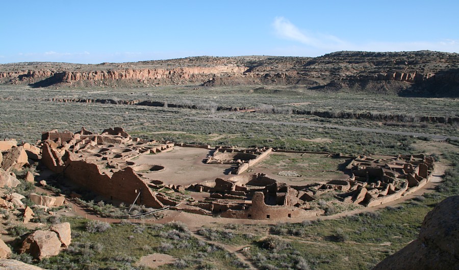
Chaco Canyon and the broader Chacoan sites
present a rich array of massive architectural constructs in a context
of an extensive, straight-line road complex, fertile ground for
continuing study and more refined focus. In 1997 Sofaer, writing "The Primary
Architecture of the Chacoan Culture: A cosmological expression,"
postulates the role of Puebloan astronomy in the placement of Chaco
Canyon Great Houses and the arrangement of outlying pueblos. Her
extensive references provide a useful long list of important previous
studies on Chaco and archaeoastronomy in addition to the academic
context of her findings. In 1999, Robert Redford narrated and Sofaer
directed The
Mystery of Chaco Canyon.
For inter-visible Great House arrangements at Chaco Canyon, Sofaer
hypothesizes major wall and site-to-site astronomical alignments.
Archaeologist Stephen Lekson in 1999,
presumedly unaware of my unpublished geodesy studies (I made several
private communications to other archaeologists), published a book
entitled "The Chaco Meridian", focusing popular attention on the
longitude coincidence of the centers of political power, Aztec, Salmon,
Chaco, and Casas Grandes. (Read a
critical discussion of Stephen Lekson's book, book review on researchgate.net by Thomas E. Emerson.) One of the criticisms directed at Lekson's political concept is the inaccuracy of the longitudinal alignments.
Precision of coincidence on a north-south
line is only one consideration in relation to possible ancient
geodesy. Meridians are a fundamental geodetic and astronomic
tool, but use of geodesy and of a meridian does not require aligning
pueblos with precision on a simple North-South line. The question
to address is whether or not the sites evidence geodesy. In an
intentional site arrangement beyond the range of intervisibilty,
complexity might be expected rather than a simple
meridian. Continuation of an observation-based astronomical calendar alone might impose a need to utilize the same longitude, but without need for refined precision.
|
"11 Ahau was the katun when
they carried on their backs. Then the land-surveyor first came; this
was Ah Ppizte who measured the leagues. Then there came the
chacté shrub for marking the leagues with their walking sticks.
Then he came Uac-hab-nal to pull the weeds along the leagues, when
Mizcit Ahau came to sweep clean the leagues, when the land-surveyor
came. These were long leagues that he measured. ..."
"... the great mounds came
to be built by the lineages and all the things which the rulers did.
They were the ones who built the mounds. It took thirteen katuns and
six years for them to construct them. The following was the beginning
of the mounds they built. Fifteen four-hundreds were the scores of
their mounds, and fifty more made the total count of the mounds they
constructed all over the land. "
THE BOOK OF CHILAM BALAM
OF CHUMAYEL, Ralph L. Roys, 1933, Carnegie Institution Wash. D.C.
|
The "width" of the Chaco Meridian, the overall
difference in longitude between Casas Grandes and Aztec, is about 0.05
degrees (see figure following). This longitudinal width equals less than a
three-mile baseline at Casas Grandes. The Pueblo del Arroyo (puar) and
Chetro Ketl (chet) great kivas are situated nearly due East-West,
spaced 0.0100 arc degrees, about 1.1 km. Note, also illustrated below,
the number of Chaco Canyon Great Houses between the Mt. Wilson (mtwi)
and Casas Grandes (cags) longitudes.

The arc distance from Wilson Peak to Pueblo
Bonito and to Chetro Ketl is near 200 km, equaling 1/200th earth's
circumference (cir/200) as do their respective latitude differences. In
addition to 14,017 foot Wilson Peak, two other 14,000 foot peaks crown
the Rockies north of Chaco, Uncompadre Mountain, the tallest at 14,308
and Mt. Eolus at 14,084, along with Hesperus Mountain at 13,232 ft. The
latitude difference between Uncompadre and Mt. Eolus is 0.4498°,
cir/800. The latitude and longitude differences between Uncompadre and
Hesperus mountains are equal. Pueblo Bonito is 1/2 degree west of
Uncompadre, and 0.1271° east of and 1.3845° (cir/260) south of
Hesperus.
Including relationships to major peaks in site
arrangement considerations adds to the complexity of assessing the
meridional site concentration. Site arrangements on an even larger
scale, extending beyond the Chaco Culture region, is another
complicating factor. A first step in defining the relationships of the
constructions is accurate knowledge of their placements. Recent high
resolution image updates in Google Earth™ adds to previous resources.
However, GPS readings of major kivas, walls, corners, etc., are
required to accurately reconsider preliminary results based on
map-derived coordinates. In the Spring of 2007, I completed a GPS
survey of the major
architectural features mentioned herein, and will add new information
after further study using the new data.
Some GPS-determined coordinates and data follow.

|
monument
|
code
|
lat
|
lon
|
|
Aztec Ruin Great Kiva
|
azrgk
|
36.835038
|
-107.999507
|
|
Pueblo Arroyo Tri-Wall
Kiva
|
patwk
|
36.061250
|
-107.966014
|
|
Casa Rinconada
|
carim
|
36.054785
|
-107.960250
|
|
Chetro Ketl Great Kiva
|
ckgkm
|
36.060229
|
-107.953729
|
|
Pueblo Bonito South Great
Kiva
|
pbsgk
|
36.060444
|
-107.961667
|
|
Pueblo Bonito North Great
Kiva
|
pbngk
|
36.060750
|
-107.961833
|
|
Peñasco Blanco
Great Kiva
|
pebgk
|
36.081639
|
-108.002722
|
pbngk - chgkm arc =
0.00657° = 0.00050 R27
pebgk - patwk arc = 0.03600° = cir/10,000
|
Chaco
Canyon Prehistoric Roadways
View
a map of the Chaco Meridian
2008.04.16
- The 2007 GPS survey data is published. All waypoints and current
derived coordinates are in a Southwest Waypoints spreadsheet (sw_waypoints.xls). A first version of
the placemarks file is now uploaded.
The placemarks illustrate a difference between current Google Earth (GE) coordinates in this area and the WGS84 coordinate system. Compare in
the image below, the Pueblo Bonito corner south east in
relation to its GPS datum (pbcse). Accuracy on the digital globe varies by
region, and GE coordinates change as updates improve imagery placement. In the GE menu, use View > Historical Imagery to compare older image placements with updated, hi-res imagery. In just a few years, the resolution amd placement of imagery vastly improves.

2009.07.01
- The Chaco Meridian and other Southwest GPS readings are providing
useful findings and prompting more questions. Data reveals
relationships and GPS data provides certainty of the accuracy of the
relationships. From Pueblo del Arroyo's tri-walled kiva to the large
plaza kiva at Peñasco Blanco (pebgk - patwk), arc distance equals
0.036001 degrees (cir/10,000). Each GPS reading has an error factor of
about +/- 3 m, and each of these two coordinates is an average of several readings. The arc
is accurate +/- about 4m from kiva centerpoint to kiva centerpoint, a
small portion of either great kiva's width. There is no doubt the arc
distance between these two major circular constructs is 0.000100002
circumference, +/- 0.00000010. Likewise, from Wilson Peak to Pueblo
Bonito and to Chetro Ketl the arcs are undoubtedly 1/200th of
circumference. The real question, of course, is "Are these
relationships intentional?" If so, another is, "Are these the intended
arc distances?" (lunar orbit per day less lunar orbit per rotation is 0.03598
degrees, a 3m difference in relation to circumference/1,000).

Click images for larger versions.
Archaeology is not an easy science
to pursue. Unlike anthropology, our informants are all dead. Not only
are we left with only material evidence, but also a mere sample of the
evidence and often without knowing what portion of the original
evidence the sample represents. Necessarily, inferential statistics is
important in archaeology. Contrastingly with descriptive statistics,
margin of error is not inherent when every person in a
population is polled. The saying "In archaeology, there are as many
interpretations as there are archaeologists" has a bit of truth because
archaeologists are often in a difficult position, either inferring
their best conclusion or saying nothing about interpretation. In
addition to this dilemma, questions like intentionality cannot be
easily inferred from obvious statistical probabilities. For example,
"Is 1/10,000th of circumference intended, or is the lunar motion difference
(cir/10,006.7) intended?"
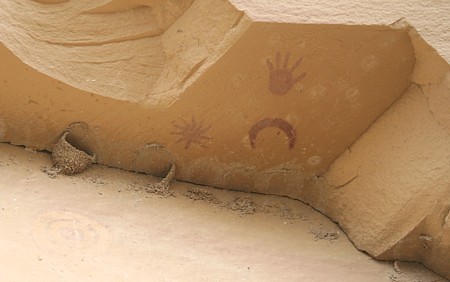
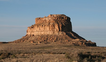
Peñasco Blanco
pictographs, Chaco Canyon, New Mexico.
Sometimes we just know things, and
statistics is not required. Reading this sentence is a good example.
You just know what it says. What if someone else who knew not about
phonetic alphabets and writing asked you to prove statistically that it
says what you say it says? Phonetic alphabets and writing are not the
only means of communication, so now imagine trying to apply a
statistical solution to "reading" a pictographic communication without
strict iconographic conventions, or reading a new codex with unknown
conventions. Reading intentionality of meaning can be difficult even
with written words. As with sentences and pictographs, context in
archaeology can sometimes be more useful than statistics. A task the
archaeologist faces, after learning to "read" the record and "knowing"
what it says, is to somehow demonstrate to others an interpretation,
sometimes in the face of entrenched paradigms propped by mantras such
as "Can you prove it statistically?"
So how do we arrive at certainty
about intent AND demonstrate same as factual? Astronomy and geodesy
provide context for monuments. Monks
Mound at Cahokia is a great example relevant to statistics and
sample size. Monks Mound is situated at 38.660 degrees latitude. The
latitude tangent equaling 0.80 transects the mound, the center of Woodhenge, and the apparent baseline of the mound complex. (The arctangent of 4/5 equals 38.65981°.) Monks Mound is a singularity, the
largest earthen mound, 100 feet high covering over 14 acres with an
estimated 22 million cubic feet of earth. However, statistics can be
applied to a sample size of one, especially in the geodetic context.
Given the distance from the pole to the equator what are the odds of
such a precise placement? Or, more narrowly, given the geographic extent
of Mississippian Culture mounds, what are the odds?
Defenders of the 'ignorant
primitive' paradigm counter with "coincidence" of course. How many
coincidences will it take to alter their current paradigm?
Is a legible geodetic codex written on the earth enough? Not if they
know not how
to read it, nor understand the astronomy involved. Those of us who are
reading it
are also guarding its secrets, protecting the fragile record from the
destruction
of criminals stealing artifacts for profit. Therein lies another
dilemma for the
archaeologist. How do you communicate information that informs respect
for a past
culture without providing those who destroy the archaeological record
with a map
to pursue their madness? A wise and older archaeologist once told me,
"I've
gone a long ways without offering any information unless I'm asked a
direct question."
On that note, if you can read it yourself ....
2009.12.02
- During the summer of 2009, I was able to complete more Aztec GPS readings.
|
Aztec West Ruin Great Kiva
|
awrgk
|
36.8350280
|
-107.9995010
|
GPS 2m, mean of 6
|
|
Aztec East Ruin Great Kiva
|
aergk
|
36.8356073
|
-107.9970025
|
GPS 2m, mean of 11
|
|
Aztec Hubbard Tri-Wall
Kiva
|
ahtwk
|
36.83611111
|
-108.00043056
|
GPS 2m, mean of 2
|
|
Aztec Ruin F Tri-Wall Kiva
|
aftwk
|
36.83595556
|
-107.99852222
|
GPS 2m, mean of 5
|
From Tikal Pyramid IV, the tallest pyramid
on the Maya Meridian, the ratio of the arcs to the two Aztec great kivas
presents the ratio of years per solar orbit (yo = 0.999962), accurate
to within 3m given the kivas center-on-center spacing (the same accuracy as the error margin for the GPS coordinates I derived). The longitude difference between these monuments (mean =
cir/19.5989) correlates with the difference between
the eclipse nodal interval (eclipse year) and solar orbit. There are 19.5988 eclipse
nodal intervals during one turn of the axis of lunar orbit (et = 19.5988 using
astronomy data for the Chaco epoch, 1050 A.D.) and 19.6130
eclipse nodal periods per lunar standstill period. The mean latitude
difference is 19.6116 degrees. There are 346.620 days per eclipse nodal
interval. The two great kivas form a triangle with sides 1.0 : 3.4667.
From Tikal Pyramid IV to Pueblo Bonito North Great Kiva, the longitude difference equals 18.331934 degrees, the same arc distance as solar orbit during 18.599602 days. The epoch Chaco (1050 A.D.) astronomical constant value for years per lunar orbit turn (yt) was 18.599603. Given the GPS reading for Pueblo Bonito South Great Kiva, the longitude difference equals solar orbit during 18.59943 days. For the intersection of the Pueblo Bonito's north-south and east-west walls, the longitude difference equals 18.59955 days of solar orbit (the astronomical value of years per lunar orbit turn in 880 A.D., yt = 18.59955). Expressed as the module solar orbit per day (so = 0.98561 degrees, epoch Chaco), the arc from Peñasco Blanco Plaza Great Kiva to
Pueblo del Arroyo Tri-Walled Kiva equals 0.036526 so.
Ancient Monument Latitudes Evidence Accurate Astronomy
Newark
Archaeogeodesy
Assessing Evidence of Geospatial Intelligence in the Americas
Download ArchaeoGeodesy, the Excel
file. Input three site codes and
automatically calculate the arc distances, bearings, and more. Applet
includes
coordinates for kivas, mounds, pyramids, and monuments worldwide.
Download Epoch Calc, an Excel
applet with AeGeo code, formulas and
calculators for temporal variation in astronomical constants,
eclipse calculations, and much more.
The Dresden Codex Lunar
Series and Sidereal Astronomy
Mesoamerican Archaeoastronomy
| Archaeoastronomy
Pages

Chaco Canyon Great Houses - QuickTime movie - 282 MB
|


