Part Six -- TRUE HISTORY ON THE ROCKS
Feb. 20. Afternoon. Texas. Dust rising from Mexican streets is visible from this perspective, the University of Texas at El Paso Library. Now 12 days after the stabbing, my healing is proceeding well. With guidance from 5 physicians, several therapies, continued medication and time my arm has returned to normal size and color. I'm beginning to utilize the wounded muscles. This morning I used the attached fingers to move shoestrings. Attempting to pull the knot was painful.
Yesterday I hitchhiked from Apache Junction to El Paso in excellent time, 9 1/2 hours. The first ride was with a drug dealer, the second with a drug consumer. The latter was also a rifle and grenade carrying paranoid Vietnam veteran. I first noticed the gun when I walked past his car while an Arizona Highway Patrol had him stopped. He reported he was hassled because the officer sensed the smell of marijuana smoke, he complained that he had been searched, and he pulled out a joint and smoked it. By the time we arrived at his destination, Superior, I'd been told he had shown the patrolman a false ID, he had spent time in prison and he would rather kill a cop than return. I asked if he was wanted.
"I'd rather not say," he replied.
From Superior the road climbs into a land of smoothly worn rock, a dizzying spectacle of rounded boulders and smooth cliffs, a myriad pattern changing with each step, incomprehensible in detail and attracting in wild beauty. I began walking the steep grade without hitchhiking. Before long my leg hurt. My pulse rising caused my arm to ache. I kept walking, enjoying the unique view. A car stopped, backed up and the driver offered a lift. I kept walking, relishing the lithic panorama, the sun and fresh air and being out on the road again. Further along, rather than enter a long, dark tunnel, I threw the thumb at a group of three vehicles. The latter of them, an old Buick La Sabre with Texas plates, stopped. I was offered a ride if I could help buy gas.
The driver, a large, lean older man with shoulders of a life of labor, said he "went broke" in California. For three months he and a friend had lived in his car and survived on the discarded sandwiches gifted by a catering truck driver. He had finally gotten some work, a house to paint. He was trying to return to his "kinfolk" in Texas. His friend had put a knife to his throat so he left him behind. He has a 9th grade education and has never earned over $5.00 an hour.
He was truly broke. When I asked if he had a dime he responded he didn't have a penny. He was on his way to Safford, Arizona, where he knew someone working at a gas station. He had stopped in Phoenix early in the morning to job hunt. The employment office computers and microfilm viewers had been more than he could deal with.
"I knew I didn't have a chance when I saw them computers," he said. So he had pushed on.
When we reached Safford he had a job, driving me to El Paso and himself homeward. We stopped to fill gas. I also filled his tank, his first meal in days.
When we crossed the Texas border, another meal and gas tank later, he was exuberant. We were in his home state where he "fit in better." He was confident that here he would "be given yard work or something." I was happy to have traveled so many miles without having to load my pack with one arm.
The pack is now in the van, a change especially suited to my physical condition. It's easy to drive with one good hand. I feel ready to return to exploring ancient America while wandering toward Oregon. Right now it's time to see what rock art information this library holds.
"Antiquity willfully veils the truth so that the fool will go astray and only the wise may know." Phaedrus, writer of fables. Roman.
After library hours. Truth or Consequences, New Mexico. Last night in El Paso I had about a mile to walk from the highway to my cousins' home, past many barking dogs in fenced yards. At one point I heard some yelling, turned, and saw someone heave something at me. I turned back to shield myself with the backpack. A large stone struck a bush beside me, very close to a hit from almost a block away. I turned again and asked if there was a problem.
The young pitcher was of the impression that his back yard dog yelped because I had thrown the first stone. I said that contrary was the case. He didn't apologize. His father came out of the house and shouted, "Get out of here, you bum."
I asked if I could use the phone to call the police. He said I could not enter his property.
I called the police from elsewhere, we returned and I said I wanted to file assault charges. When the cops returned from in the house I was informed that the residents wanted to file charges against me for "cruelty to animals," a class A misdemeanor, that my charge was a class C felony and that we would both be taken downtown and booked. They asked if I would like to drop "the entire matter." I said I might still wish to file charges. They had to proceed with a crime report. I was thereafter permitted to depart.
I'm sitting at the bar in a club called Ashbaugh's. A country western band is playing. All the men scuffling about the dance floor wear cowboy hats, vests, bolo ties and high heels. My whistle is wet and a smoker just lit up beside me, so onward.
Feb. 21. Midday. Sun shining bright on Isleta Pueblo. It's quiet and peaceful. The only dog I've seen approached and silently begged for strokes. The only sounds are birds, pigeons and a man preparing firewood. The streets and homes have a truly ancient character. The air is clean. Hardly a car passes.
I'm beside St. Augustine's church, near the center of this village-maze. The homes and pathways predate modern transportation and perhaps the arrival of the horse. St. Augustine was built in 1716 on walls found standing in 1692, 12 years after the Indian revolution. Originally built as St. Anthony's in 1613, this was one of the first churches built in the present day USA. Except for the distinctly Southwestern architecture of the church I see no visible clue that this is not Mexico. The village undoubtedly looks like it did when this was a province of New Spain.
During the 1680 Indian revolt against the Spanish conquerors the people of this pueblo remained peaceful while the other pueblos routed the Spaniards. Fifteen hundred defeated colonists from the surrounding areas took refuge here and Governor Otermin retreated to here from Santa Fe with another 1,000 survivors. The subsequent Spanish retreat to El Paso was the worst setback of the American conquest for Spain, the world's most powerful empire at the time. Otermin and 130 troops returned the following year bent on reconquest. Upon retreating anew nearly 400 Isleta inhabitants accompanied the Spaniards and resettled in El Paso.
Today about 2,000 Isleta Indians occupy this 200,000 plus acre reservation. New Mexico has 27 reservations, the majority being pueblos in the Rio Grande valley. Five distinct languages are spoken by the pueblos, including Keresan, a language unrelated to other American languages. After the Spanish intrusion many pueblos were abandoned and languages have been lost.
Feb. 22. Albuquerque. The University of New Mexico campus has a splendid pedestrian commons in front of the library, a multi-level plaza of sorts. I noticed a young man sitting on the rim of one of the large plant containers. He held a camera with a long telescopic lens. I continued up to the Student Union level and off campus to a good beanery. While returning I stopped near the Student Union entrance at a sidewalk vendor stand and squatted to pick up and examine a copy of Overthrow magazine. From that perspective I noticed that the telescopic lens was pointed at me. I asked the magazine vendor what he thought of the arrangement.
"The guy is probably paranoid that radical feminists will rule the world," he responded.
Great sense of humor. Off walked the two females present. I walked the long way around and found a balcony above and behind the photographer. I was convinced that he photographed people interested in Overthrow magazine by the time he turned and saw me, whereupon he immediately departed.
It's another warm afternoon, perfect for sitting in the sun. The immense, rugged and rocky range visible and dominating the view to the east, the Sandia Mountains, made archaeological history in the late 1930's. Kenneth Davis reported a human habitation cave to his professor, Dr. Frank C. Hibben, who directed excavation of the site. Hibben and his associates initially found occupation evidence with Folsom points, named for the site near Folsom, New Mexico, where in 1926 the point style was discovered amidst fossilized bones of an extinct bison species. At the time the Folsom site was considered the oldest evidence of human occupation in the Americas, estimated at 10,000 years, a theory not readily accepted in its day.
Below the Folsom people's layer the Sandia Cave excavators found a considerable layer of fine yellow ochre and below that a separate, earlier level of occupation with boulder outlined hearths. The archaeologists uncovered bone fragments or teeth of mastodon, mammoth, camel, horse, giant sloth, giant felines and large wolves as well as flint knives, chipped flint scrapers and crudely-made, roughly-chipped leaf shaped points which they dubbed Sandia points. The yellow ochre layer, geologically dated at 25,000 B.C., provided proof which more than doubled the span of human occupation in America. This gave the Sandia people the distinction of being America's earliest known people at the time. Later radiocarbon dating supported the geologic dating, a finding not readily accepted to this day. Well, enough sun, back to the books.
 |
Feb. 23. Morning. Galisteo, New Mexico. After a day and a half collecting data I began to crave the real thing and some outdoor exercise. I fought sleep while driving late last night, then camped on a highway pullout and, surprisingly, found glyphs within sight on awakening. The first passerby, an equestrian, provided further local site information and directions.
I've stopped to purchase food. Film is unavailable. The church bell is tolling. Today is Sunday. Spaniards arriving here in 1540 found Tano speaking pueblos in this vicinity. Now only a small village of unrelated people remains. Tano residents were among the leaders of the successful 1680 revolt. Rock art of the prehistoric era remains. The day is young, the weather is ideal. Several sites are nearby.
Sunset. Somewhere in New Mexico after a drive to Santa Fe for film. Sitting in the breeze and diffuse light on a large boulder facing an overhang decorated with ancient painted masks. A prehistoric masonry tower stands amidst a downfallen habitation complex beside the stream below. I cannot count the number of perfectly preserved petroglyphs on towering boulders and cliff faces here, not enough time remains today. Indeed they are many and delightful. Also many are the questions of what life was like for the artists. A modern livestock corral has been erected across the stream from the ruins. Occasionally an automobile sounds down the highway. Bird songs and the sound of wings compete with the wind more so than not. Swallow nests of mud share the pictograph shelter. The people are gone. For how long did humans live here? How many more ruins lie in obscurity behind signs reading, "Private Property. No Trespassing. Violators will be prosecuted"?
Later. It's pastel in the west and otherwise almost dark. A large bright full moon is shining through thin clouds. The cows have settled down for the night on the sage covered ruin mounds. The people are indeed gone from this place, yet it is alive with their artistry. Onward to Santa Fe.
Feb. 24. 8:15. Having breakfast. In the morning press the world keeps changing. Trouble in the colonies again. Rebellion is in full swing in the Philippines. Is the U.S. Air Force readying a treasure fleet, the modern equivalent of the old Spanish Galleon? In El Salvador the son of the Air Force chief and friends celebrating a birthday were all shot. They were mistaken for leftists at a roadblock. On the spot firing squads have the inherent risk of killing more than just politically incorrect people. Was I stopped at the same road block? Could such a fate have been ordered for me? How far left is leftist?
"Past is prologue."
"A Nation that forgets its past has no future, Winston Churchill."
From the wall of the New Mexico Archives.
Midday. Santa Fe. The plaza. I know of no other plaza with a Haagen Dazs ice cream shop. Originally this plaza featured a whipping post and a gallows. A fusion of cultures and centuries is everywhere evident in this neighborhood.
In 1540 Coronado, New Mexico's first European explorer, visited the Rio Grande pueblos while searching for the legendary seven cities of gold. Spanish colonization and subjugation of the Indian populace began in 1598. The first Spanish capital was established that year at San Juan pueblo. In 1610 the second Spanish governor, Pedro de Peralta, moved the capital by founding this city, "La Villa Rica de San Francisco de Santa Fe," which means, "The Royal House of Saint Francis of the Holy Faith." The Royal House refers to His Majesty's seat of government and combined Governor's residence, the building I'm leaning against, today called the Palace of the Governors. This oldest European public building and oldest European seat of government in the present day United States is an adobe fort more so that a palace.
The building was the last refuge of Governor Otermin and the survivors of the Pueblo Revolt. After the Indians cut off the flow of water to the building the Spaniards retreated to Isleta. Diego de Vargas led the recolonization in 1692. On his arrival Tanos Indians held the Palace. De Vargas cut off the water supply and then entered the building unarmed to negotiate for peace. The recolonization was less than peaceful.
Today people from the world over barter with local Indians under the front veranda where the native craftspeople are displaying and selling exquisite turquoise and silver jewelry. Native art and other fine art galleries surround the plaza and line the side streets. Onward now to the Palace interior, part of the Museum of New Mexico.
Oh, our mother, the earth; oh our father the sky,
Your children are we, and with tired backs
We bring you the gifts that you love.
Then weave for us a garment of brightness;
May the warp be of the white light of the evening,
May the weft be of the red light of evening,
May the fringes be the falling rain,
May the border be the standing rainbow.
Thus weave for us a garment of brightness
That we may walk fittingly where the birds sing,
That we may walk fittingly where the grass is green,
Oh, our mother the earth; oh, our father, the sky.Pueblo Indian poem
Late evening. San Francisco Street Bar and Grill. M.L., who I met at the El Salvador museum, just said hello. He is in Santa Fe to attend a museum specialists meeting tomorrow at the New Mexico Laboratory of Anthropology where, coincidentally, I've made arrangements to use the research library. It's a small planet indeed.
Feb. 26. Hillside Park. Santa Fe. Midafternoon and 75 degrees is most satisfactory for this latitude and altitude, 7,000 f.a.s.l.
Today I found on the back cover of a 1931 issue of the New Mexico State Museum publication, El Palacio, a photograph of a Vernal, Utah, rock art panel and the following as interpretation:
"This scene is that of a war party returning with the heads of the vanquished men and with their women as captives. Notice that both of the women are wearing cedar bark, cord skirts and that at least one of them has her hair whorled....And again, we are probably looking on a return of a victorious war party that made its raid years before Caesar crossed the Rubicon."
This baseless interpretation, written not many decades after the Indian wars, reveals more of the culture and psychological projections of the writer than of the rock art. How many of the interpretations of our day do likewise? Wouldn't it be an equally likely interpretation that the panel depicts the discoverers of America?
Today's press reports that deposed Philippine President Ferdinand Marcos is expected to arrive in our nation aboard U.S. Air Force transport. Also, President Reagan made a formal request for $100,000,000 to overthrow the elected government of Nicaragua. He stated, "If we fail to help friends in need now, then the price we will pay later will be much higher," and "I do not intend to introduce the armed forces of the United States into combat against the government of Nicaragua..." How much armed force will $100,000,000 buy? How many M-16s, M-60s, ammo belts, beans, tortillas, helicopters, bullets, rice, bananas, boots and bombs? How many bazookas, breakfasts, bombed bridges, bodies, beneficiaries; how many more mothers of martyrs?
Feb. 27. Low afternoon sun rays on Cienega Butte. On a rock, "Ernestina Gallegos, July 25, 1934, a rainy day at 3:00 p.m." She wasn't looking down on thirty mobile homes nor did the ancient mesa top inhabitants who built enduring stone walls and inscribed 1,000 plus petroglyphs here.
After sunset. Another graffiti: "1981 - Romero - May he own this land forever." When I arrived below I asked a man amidst cattle in a pasture if the basalt cliffs were the Cienega Mesa rock art sites.
"Yes, that's my land up there," he responded.
Those shouting insults across the mobile home neighborhood are being shouted down by their neighbors.
Mar. 1. Datil Well Campground. Exciting news...Jen, a dear friend and fellow rock art aficionado, flew into Albuquerque yesterday to take part in this wandering for 10 days. This is the second outing of what she has dubbed, "The Glyph Team." Last summer we spent time visiting rock art sites in southeastern Utah. Her pleasant and good company is a welcome change; her love and savvy of the wild desert is an asset. We've had breakfast, our gear is loaded. The Glyph Team is ready to roll, Arizona and SE Utah bound.
At the campground entrance:
"Historic Hoof Highway. Water you drink here comes from Datil well, one of 15 wells spaced every 10 miles along the Magdelena Livestock Highway. Established 1885, this historic "Hoof highway" joined Springerville, AZ, 95 mi. West with railroad at Magdelena, NM, 37 mi. East. During 1919--Peak Trailing Year--21,677 cattle and 150,000 sheep passed over trail...."
Mar. 3. Flagstaff. Museum of Northern Arizona. The Research Library. Jen is viewing the displays. After collecting data about sites on our itinerary I researched intaglios, also referred to in the as geoscripts, geoglyphs, earth drawings, earth art, ground art, ground figures, gravel effigies and gravel petroglyphs. These phenomena are reported from Australia, New Caledonia, South and North America. To my surprise 275 are known in California, Arizona and adjacent Mexico. Some are exciting artworks, some are enigmatic and some are 10,000 years old. Many intaglios have been discovered from aircraft, many have been irreparably damaged by off-road vehicle use. They are located south and west of here.
Our sojourn is to the north into the wilds of that fast track to the past, the Colorado Plateau desert, where ancient human marks are as well preserved as the fossilized dinosaurs. We've decided to spend the next week camping this least inhabited region in the lower 48, reading the walls of prehistoric abodes, studying and photorecording some of the world's finest rock art and attempting a glimpse of the life and times of ancient fellow humans.
Later. Jen found a 1930's publication with an aerial photograph of Ha-ak Va-ak, the Gila River Indian Reservation intaglio I visited in December, which we measured yesterday. The team concept has frequent dividends, this a confirmation that Ha-ak Va-ak is well known. Onward to visit Hopi petroglyphs and the Hopi mesas.
Navajo Nation. March 4. Painted Cave. In every direction there are ruins of the Ancient Ones, the "Anasazi" in the Navajo language. The famous Mesa Verde cliff dwellings lie to the northeast in Colorado. The Hovenweep towers lie to the north in Utah. Three of the most spectacular cliff dwellings, Keet Seel, Inscription House and Betatakin, are located in Navajo National Monument to the west. To the south a profusion of ruins are found in Canyon de Chelly National Monument. To the southwest lies Hopiland. And to the east along Chaco Wash in New Mexico the Anasazi constructed more than a dozen large communal buildings, pueblos. The largest, Pueblo Bonito, had an estimated 650 rooms and 32 kivas and stood four and in places possibly five stories. None of these well known Four Corners region ruins can boast the uncommon great number of wall paintings which decorate Painted Cave from one end to the other, spanning hundreds of feet.
Our modern vocabulary must be used selectively to describe this ancient ambient. The "wall" painted here is not two dimensional, but rather the natural, rough, varied, multicolored, multidimensional sandstone recess, the back wall of a natural shelter. The "cave," wider than deep, is a cliff overhang, the cave floor is the top of a talus slope, a steep mass of sand and broken rock against the cliff.
Most of the art is attributable to the pre-ceramic or Basketmaker cultural period. Eventually 15 rooms and a kiva were built. Evidence unearthed during excavation indicated occupation prior to the ± 400 A.D. pottery horizon, therefore long before the Anasazi began building masonry walls. Only a few of the stone walls survive, the tallest about 7 feet. Two rooms remain enclosed. Adobe plaster still coats the kiva interior. Tree ring analysis determined that the kiva's now downfallen main roof support beam was felled in the summer of 1247. The portions of the cliff painted after walls provided easy higher access may be of approximately the same vintage though the art is stylistically uniform..
More than 1000 handprints, mostly paired and vertically oriented, predominate the "canvas." Most commonly red, they are painted directly onto the cliff as opposed to applying a painted hand or silhouetting a hand by spraying. One pair has six digits per hand! Human-like figures are the other important element. The about 50 anthropomorphs, mostly of Basketmaker origin, range in size from 6 inches to 5 feet. Several are embellished with projections from their heads, others have distinctive stylized heads. Wavy lines, triple-lined zigzags, triangles and a square complete with immense, aboriginal creation. Red, green, yellow, white and blackish-brown are the ancient paint colors.
Ravens are calling and a songbird sings loudly. It's sunny and breezy. Water is visible flowing in the canyon's deep ravine below. Near the canyon entrance we spoke with E., a Navajo man who provided final directions and permission. He is a member of the grazing committee and discussed the land. "The Navajo must take care of the land, it is the only land we will ever have, yet people continue to exceed grazing quotas," he explained. He spoke of how his people don't move around. He said he has met many whites, but they always move on. He is retired and building a new hogan. He cannot move across the creek because that area is grazing land. He cannot construct a hogan just anywhere on the land his family uses.
The ravens are now calling loudly. On the rocks the following is inscribed: "VIII Bernheimer Exp. 1930 Am Mus Nat Histy NY J.W. G.O. E.R.M. C.I.B."
Utah. March 6. Facing a painted cave. The sandstone overhang is immense, the art is multicultural and multistoried. High above, sheltered deep under a flat, horizontal section of overhang, a wide, smooth sandstone canvas is painted with apparent attention to fine detail. The effect is one of delighting this viewer. Along the present day talus slope top, 20 feet below the upper canvas, great congregations of life-size anthropomorphs command attention--messengers from the past. I'm lying in the shade beside the canyon bottom spring, viewing details of the expansive painted overhang with modern binoculars. Jen is exploring up canyon.
The anthropomorphs are in groups, have stylized heads, are painted in white and vary from faint to very faint. Some of the very faintest are partially overpainted in red, an accentuation by later era artists who also painted handprints. High above the talus and off to the right there is a small, solitary mask similar to those at Hueco Tanks, Texas. One site, four distinct styles.
The large upper panel puzzles me. It is truly singular. I do not recognize its style. In style and location, in paints and designs it has no relationship to the lower panels. Among the upper figures some are dim and appear old in relation to others. Was the upper panel painted during a long period of occupation at that level? How much time passed for the talus to erode 20 feet down the cliff face, millennia or a mere second? How must older is the upper panel? When did humans first discover this spring?
Vertical cliffs rounded by the ages rise 500 feet above and all around. Few and far between trails descend into this deep, sheer-sided labyrinth of entrenched meanders, deep overhangs and subsequent well preserved art and architecture. Here humanity seems a belated afterthought, a recent triviality on a monumental backdrop of timeless rock.
Yesterday, at the Butler Wash-San Juan River confluence, we also viewed more rock art than the mind can ingest. Access was a day hike like today, plus 100 feet long crossings of over hip deep water, cold winter water. I would have turned back, but Jen's bravery and insistence prevailed. The many confluence area sites are petroglyphs incised on sheer, exposed cliffs with patina, the dark ferromanganese oxide accumulation on rocks in millennial deserts. Pecking through this surface patina to expose the much lighter, unstained rock interior produces both vivid contrast and the more enduring relief outline. The most complex panel is the most vivid and therefore the most recently petroglyphed of the multitude of anthropomorph groups. Fully repatinated and smoothly weathered images attest to early occupation. Among the oldest petroglyphs are yucca flowers, an element also painted in the upper panel here.
Early this morning at our Muley Point overlook campsite, high above the deep, shadowy Goosenecks Canyon of the San Juan River, we lingered observing the earth's rotation by the shadows, especially of the distant tall sandstone towers and buttes of Monument Valley. All my life my language has taught me to see the sun "rise." This morning I sensed and felt the earth turn. With a geography of mile-long shadows even rotation speed was somewhat perceptible. In a still moment, the illusion of stillness shattered. Life is not a slow ride. This afternoon it is sunny and hot just like yesterday. Last night was mild.
Coyote Canyon. Orion still visible. It's freezing cold without sunshine. Jen, wearing cutoffs, is sleeping on barren sandstone beside the fire I'm taking a turn tending. If the fire suddenly burns too hot or gets too low Jen will awaken as has happened. I'm wearing a thin cotton shirt and jeans. I'm cold on one side and hot on the other. And I'm hungry. This indeed qualifies as a primitive night.
Having missed one turn in this maze of canyons now means waiting until morning to scale the boulder strewn talus slope we descended. It also means we got lost. I led us past our side canyon exit route. After losing too much time we refound our way and hastened. Unwilling to accept defeat, hunger and cold we put off stopping to camp so long that some hurry was required in near darkness to gather firewood. This first energetic activity for my healing arm was painful. Finally, exhausted, side by side and in unison we leaned back to rest against the sloped cliff base and immediately the greatest meteorite either of us has to date witnessed crossed the sky, a timely consolation brightening the sandstone framed cosmos.
The mountain lions of this region crossed my mind. I started the fire. Oh what an impressive thing a fire is, the necessary warmth, the light dispelling darkness. Would humans be alive today without such an energy source? Could the earliest arrivals have migrated to America without fire? We both have matches. I admit to thoughts of modern conveniences, grocery bags, sleeping bags and even helicopters, but actually I rather like this perspective, the utterly primordial perspective of a pair of humans taking turns tending a fire to survive a cold night in the wilderness. This is a special glimpse of our primitive human heritage.
Late morning. Surroundings visible in the hot sun. We survived the wilds and cold. I can still claim the ability to sleep anywhere. I think I slept twice as much as Jen. She is now asleep in the van. I'm seated on a broad ledge facing the rock wall far above a canyon bottom habitation site. Above, on a difficult to access narrow ledge, an approximately 12' high petroglyph panel spans 45' across. It appears to be the work of one artist, at least in design. The solar illumination is at the perfect angle for petroglyph photo study. The solar warmth this morning feels like life itself, totally essential.
Sunday afternoon. Grand Junction, Colorado, where Rocky Mountain drainages meet and the glyph team parts. Jen is presently on a bus climbing the Rockies. I do miss her. I no longer miss my watch, though a time inquiry was necessary to arrive at the bus station on time. I've lost track of what date it is, not to mention minutes and hours. The sun, moon and stars are appropriate references for prehistoric sojournment.
Two days ago, at the first light of dawn, a hungry, ill-rested and chilled glyph team climbed out of Coyote Canyon so today must be March 9th. Since that morning this pen has been idle, an omission I must redress. The last two days were filled with the messages of a previous age overlaid upon today's world and vice versa. After stopping in Monticello to take showers and purchase groceries we drove non-stop to Newspaper Rock, a cliff facet on Indian Creek cluttered with seemingly uncountable petroglyphs, one great page of history spanning thousands of years. The brightest, most recent glyphs, the last headlines, include people riding horses and bows and arrows. Vandals have added postscripts. Along Indian Creek there is more rock art than we had time to view before dark. Sunset was partly cloudy. We spent the night at a real campground in Canyonlands National Park, cooking with sherry and sleeping all night in total comfort.
Yesterday morning a hitchhike up Salt Creek's 4 wheel drive trail facilitated exploring farther up canyon than planned. The return hike down drainage passed Peekaboo Springs, a rock art site with a very faint Barrier Canyon style pictograph panel and a later period abstract white painting, the second site to have more recent painting placed on and near panels so faint they would otherwise go unnoticed. Is this perhaps the work of a prehistoric American park service? The modern U.S. National Park Service plaque also calls attention to the faint ancient images and interprets the Barrier Canyon style painting as 3,000 to 7,000 years old.
The cloud cover increased all day, sparing us a day hiking in the hot sunshine. Again we spent the late afternoon atop the Indian Creek talus slopes viewing more of the many petroglyphs. Indian Creek indeed! With darkness we drove north. Los Angeles traffic reports on the radio brought more than a little laughter. A few raindrops fell and wind began whipping up sand. The radio weather confirmed what we were seeing. Jen accepted my suggestion of Mexican food at La Hacienda restaurant in Moab, a pleasant change after eight days of pure camping.
After more than that many days of sunshine the arrival of clouds proved to have been a forewarning of change. We sought overnight shelter from the storm by camping between the deep sandstone fins along the Colorado River. Rain pelted the van roof overnight. The wind was forceful.
With present weather permitting, time permits study of another site today. Back to Utah, to the Book Cliffs. More about these last two days later.
Late evening. Ben's Cafe. Green River, Utah. The so-called Spanish Trail, an overland route from Santa Fe to California established in 1829, crossed the Green River here and the Colorado River near Moab. The first extensive explorations of the Colorado Plateau by Europeans were expeditions in 1765 and 1776-77 led by Spanish Franciscan friars Francisco Anastasio Dominquez and Silvestre Velez de Escalante. Their purpose was to locate a route to California. American and Canadian fur trappers also entered the area while the uncharted plateau was still part of Mexico. There is little record of their penetration of the magnificent, deep canyons. An exception is French-Canadian, Denis Julien, who left an early inscription on the canyon walls near the Colorado-Green confluence in 1836. The famous John Wesley Powell raft explorations of the Green and Colorado Rivers occurred in 1869 and 1871-72, decades after the War on Mexico.
Yesterday, during our exploration of Salt Creek, the National Park Service Rangers sent Jen and I on a misinformation hike, a problem unknown to the first explorers. Early in the morning we stopped in the Canyonlands National Park Needles District Office. I had determined to visit the Peekaboo Springs Barrier Canyon style panel. With my park topographic map in hand I asked the rangers about other rock art sites accessible during the same day hike. For reasons of site protection getting cultural resource information from National Park Service personnel can be practically impossible. I thought I was beginning to adapt to the difficulty. I told the two rangers of a previous misinformation hike and subsequent successful visit. After some further conversation about the horrors of vandalism the young ranger gave me instructions on the topography map, complete with pencil marks, to a "nice panel." At the end of our conversation the young ranger walked back to a desk.
I overheard the old ranger say to her, "If they can't find them themselves, well, that's that."
I trusted the kind, young, apparently like-minded ranger, forgetting the axiom, "the clerk is not at fault." We searched around, near, above, up canyon, and down canyon and the next canyon and the same places again, trusting the kind, wholesome, Smoky the Bear-suited, smiling young woman's map marks. We found a small ruin with five handprints but no "nice panel." By the time this fuming searcher returned from the wilderness the office was closed, denying us a clarification of the "mistake." Don't let that Smoky the Bear suit fool you, some of your federal servants are under orders to lie to you. To protect your cultural resources for you? From you? You from them?
At the Indian Creek talus slopes young rock climbers told us where to find the best petroglyphs. Their information was accurate. We viewed petroglyph panels until near darkness before driving to Moab..
Monday morning. We awoke yesterday morning near Moab sheltered between sandstone fins, disappointed by the weather change and reminded of the true season, winter. The same weather could have tricked us the night we slept in Coyote Canyon. The desert does not complain of rain, it rejoices with a sudden shift of colors. We donned layers of clothing and rain gear, stepped into the cold, windy morning air and began hunting mastodon in one of their surviving forms, petroglyphs. On a geologic shelf above our river elevation campsite, deeply etched into a sandstone fin wall, we found the 3' mastodon, seemingly spraying its back with water.
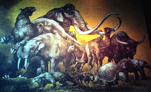
America's first settlers discovered great beasts. Some were probably easy prey, like the giant sloth. Other now extinct creatures were much more respectable. The giant bison was twice the size of its few surviving cousins, the buffalo. Perhaps the most dangerous enemy was the six-foot tall saber tooth tiger, a creature which, I imagine, related to children much like house cats today view mice. I've always liked things which challenge present views, which force questions, which provoke inquiry, which contradict even. Several mastodon petroglyphs have been reported. Imagining humans cohabiting this landscape with the giants of the ice age presents more questions than a few mastodon glyphs can answer and that is what I value in them. The weather was certainly appropriate for pondering ice age humans and their now extinct fellows.
The rains and cold wind did little to deter our viewing the glyphs along the cliff bases on both shores at the present river level. Downstream from Moab the convoluted durable sandstone forms and recesses which have confined the flow of the mighty Colorado for ages sheltered humans for millennia. We enjoyed the wind sheltered canyon and the artistic impressions of its former inhabitants, the greatest remaining evidence of their presence.
The drive up mountain and upstream to Grand Junction was one of rain and clouds climbing the same route. I was saddened by saying good-bye to Jen. A great rainbow brightened the return to Utah. Indirect late afternoon light illuminated the canyon at the Book Cliffs concentration of rock art, panels from diverse cultures and millenia. Book Cliffs indeed.
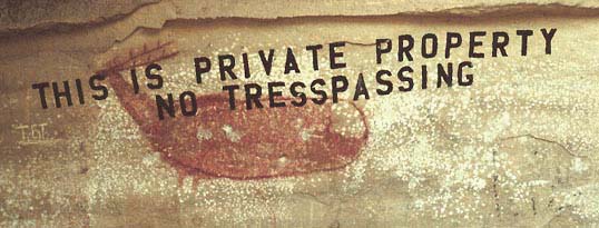
Sip and Glenna Farley superimposed their names and the date, 1914, in green paint on two panels. Not just once, but twice Sip and Glenna chose a spot for bleaching immortality and in this expansive desert with thousands of square miles of infinite rock forms, uncountable billions of canvases, twice Sip and Glenna placed their names on someone else's painting. Imagine Sip and Glenna visiting the Mormon Tabernacle or the state capital with their green exterior enamel. Or the Mona Lisa! I'd like to have a talk with Sip and Glenna. What would they tell us of the glyphmakers from their 1914 perspective. Sip and Glenna, your names live on as a testament to your time, immortal ignorance on a wall. Sip and Glenna, you are not alone, in nearby Nine Mile Canyon someone painted in bold modern letters "NO TRESSPASSING THIS IS PRIVATE PROPERTY" on the most extraordinary prehistoric elk pictograph that shall ever exist; a cave dwelling monument to ancient art, modern stupidity, bad spelling and, in all likelihood, a new concept in the neighborhood.
Those who came before Sip and Glenna painted with pictures. The most recent Book Cliffs panel is of sun, earth, men, buffalo, horses and rifles, a separate style beyond a doubt. Which panel is oldest is not as easy. One panel of diverse images has superimpositions which answer part of the question. Several panels are Barrier Canyon style, considered the oldest of the Colorado Plateau's pictograph styles. The panels are on film now with after-storm pastel orange sunset lighting.
I needed to restock film this morning. A phone call to Oregon defined my schedule. Only one week of wandering remains before I return to construction projects. On the airwaves Mutual Radio News is presently headlining "gasoline sells for 29¢ a gallon in Kentucky." The Challenger cabin was found. The President is lobbying for $100,000,000 in contra army funding.
A stonewall like no other rises before me, I'm at the base of the San Rafael Swell listening for a weather report. "McDonald's filet of fish is 45 per cent saturated fat." Visible from this perspective are many formations of the earth's previous ages. The desert barren and colorful strata were once violently lifted, warped and tilted from deep in the earth, an action which created a 60 x 30 mile geologic blister called a "swell." A mile thick cross section of the earth's crust is here exposed. From east to west the traveler crosses Mancos shale and formations named Dakota, Cedar Mountain, Morrison, Summerville, Curtis, Entrada, Carmel, Navajo, Kayenta, Wingate, Chinle and Moenkopi. Many of these formations were named by John Wesley Powell. The revved up diesels, recreational vehicles, buses and autos charging upgrade at 70 mph are simultaneously traversing millions of years per mile back in time--down--down--deeper into the earth, rapidly approaching reptile tracks of 235 million year vintage. From this perspective immense tongues of the durable Navajo Sandstone, the least erosive of the strata, rise into the air. The traveler of this region is soon aware of geologic vocabulary like "reef, an impassable barrier." Only a few narrow canyons pass through this 50 mile long wall of steep slopes, flatirons, hogbacks, overhangs, deep recesses, and balanced rocks, a maze of otherworldly eroded forms. On the other side of this reef smoothly worn sheer cliffs tilt away from the swell's center or knob. Well, onward to explore for a cluster of Barrier Canyon style panels. More views of the past await.
11:00. 7,000 f.a.s.l. The radio forecasts colder. Weather condition warrant staying tuned. A strong wind is blowing. The snowflakes are melting on landing. Thirty-two degrees, I'd guess. I'm at a gate in the ditch along I-70, an outlaw exit. Onward into the pasture. The radio forecasts colder.
Afternoon. Sheltered in the van near a pictograph, a two-legged zoomorphic circle with a head possessing either horns or large pointed ears. Though this solitary image was once named the "devil in the pasture" I suspect the painter knew not of devils nor pastures. Nearby on the south facing cliff portions of other pictographic figures, red in color, protrude from below the sand. A simple petroglyph decorates the best recess. Light snowflakes are flying. The radio now reports 12:25 and 40 degrees in Price. I've changed to wool socks and leather boots, and added jacket, raincoat and gloves. The wind is blowing hard and fast. Clouds are flying by. A few panels remain nearby, then back to a milder altitude.
Another site. Two panels. One is missing the top half, the other is faint. They are now on film.
Yet another site. Yet another two panels, these the most beautiful. A stream of sand has washed over portions of one large anthropomorph. The unaltered panel is the best preserved of the known Barrier Canyon pictographs. The snow is now showery, waning and waxing. The sun occasionally threatens a direct ray. Snow flurries at midday brightness is certainly an ideal illumination for pictograph photography.
4:02. Ray's. Green River. 4,200 f.a.s.l. on my altimeter. Below the clouds the weather is more comfortable. I'm warming up with hot coffee. Coffee and tobacco smells, cowboys crowded around a lively card game and America's country home, the Nashville network, fill the warm air inside this tavern-burger bar.
4:50. News Flash. Winter Storm Warning. This a la primitive winter glyphing expedition was possible due to weeks of sunny winter weather. I shall leave the predicted weather to the mastodons. I'm calling a stop to rock reading for this winter. Suddenly it's time to jump into the van and begin the drive to the warm Pacific coast spring. I see daffodils already.
Mar. 11. 11:00 a.m. Tuesday. Provo, Utah. A burger joint. Two Brigham Young University seniors who ate in the next booth convinced the waitress that they had received empty hamburger boxes, thereby ripping off seconds. They drive a new BMW. Well, onward to the BYU Library to copy information about Izapan archaeoastronomy for the Tapachula museum.
Afternoon. BYU Student Union. A sign blocking the sidewalk near the library exit urged me to attend this lecture on U.S. policy in Central America, part of a lecture series.
We all just stood as a student labored and sweated through a poorly delivered supplication to his Lord for guidance on behalf of all present. The lecture title is, "The U.S. Position on Nicaragua: Myth or Reality." Guest speaker Scott Armstrong is being introduced. We are told he is Executive Director of the National Security Archive, he is on leave from the Washington Post, he assisted Woodward and Bernstein on The Final Days and he is credited with discovering the Nixon tapes. His lecture has begun.
"I came to the desire to hold my government accountable for the things it says."
"There comes a time when an administration's actions, when a government's actions, become so odious that one is forced to speak out."
"The first contras were supported by the Carter administration. They were based in Florida..."
We are also being told about UCLA's, Unilaterally Controlled Latin Assets, special operations units of the United States Armed Forces that look and speak like native Latin Americans. CIA Director Casey has briefed Congress acknowledging their major role in covert Central American activities. In no unequivocal terms Scott Armstrong has informed us that the Reagan administration's Central American policy is both wrong and inconsistent. He needed more than the short allotted time to fully state his views. Lively questions are being posed by the audience.
Later. Again in unison we stood as a student spoke out loud to his God before the introduction.
"Duarte democratically elected by 80 percent of the Salvadoran people." Ms. Villa, representing the U.S. State Department, is speaking. She was born in Cuba. She says the Soviets have spent $500 million to militarily aid Nicaragua. Morality is mentioned and the Soviet aid is compared with U.S. activities, especially the Caribbean Basin initiative, and that thanks to the Reagan administration's Caribbean Basin initiative baseball gloves and bats are cheaper and, regarding the militarization of Nicaragua, "The only thing we have been aggressive with is our words...."
I have prepared a question of Ms. Villa. Her answer is, "No, it is not the policy of our government to murder people based on political association."
Mar. 12. 9:13 a.m. A smoke-filled cafe on a main street in Utah. John Wayne decoupages, bovine horns, prints with artistic impressions of cowboys and people dressed like artistic impressions of cowboys surround me. From here the road towards the northwest climbs out of the land of fog until further notice, the Great Basin. This inner region lacks a drain and the ancient shoreline of prehistoric ice age Lake Bonneville is plainly visible as a shelf on the mountains and hills in every direction and in three states. That eroded shoreline is hundreds of feet above this town, Utah's concentrated population, the airport, the transcontinental railroads, the golden spike, industries, rich, lake-bottom farmland and this town. In recent years the salty remains of that once vast inland sea have begun rising again, pushing back residents and covering highways. Regional headlines indeed!
The northwesterly most Barrier Canyon style pictographs are located near here, on the mountainside above Willard. I have questions about that site, a cave. One looms largest: "Was it painted just above the ancient shore?" Did the first humans to arrive in this region find the lake full? The questions must wait. On this cold winter morning I don't feel like hiking to snow line.
Idaho. I-84. Near the Utah border a historic marker reads:
"Lake Bonneville. 20,000 years ago this land was under water. Not far to the north you can see the old shore of Lake Bonneville. Formed in a basin from which no river reached the ocean, this became the largest lake in North America. Finally, the lake rose high enough to overflow into the Snake River. Then after the climate got drier, and the Great Basin of Utah and Nevada became mostly a desert, the lake receded. Salt Lake and two other remnants are all that are left of this old 20,000 sq. mi. lake. "
Lake Bonneville is gone, but not the way the mastodons are, the lake can return. It seems to already be doing that. Perhaps in the long cycle of things it must. North America's largest lake, the ice age, mastodons and saber-toothed tigers passed quickly. Our planet can really shed its skin from time to time--ask the dinosaurs, ask the family in Mexico that had a volcano come up in "their" cornfield. Worry not about whether things will change, fasten your seat belt, I'd say.
On a personal level change can happen at any moment and in only a moment. Something happens, an earthquake, a volcano, a war, a knife or a triumph. Suddenly it's history and things have changed. Resisting or not accepting change is futile. Scars cannot be denied, nor can dinosaur fossils. I wonder, does the world change as quickly on a grand scale?
Change has happened quickly for humanity. Many tribes and languages are extinct. Yet at the same time, since the end of the ice age, human population has soared. An advance? A natural aberrance? The recent great wave of humanity to America is history. You can read about it in Utah's rock art; horses and guns, trains and plows, Sip and Glenna Farley, No Tresspassing This is Private Property. What about before history, before the first boatload of Europeans, how well will we understand American prehistory, the first human migrations to occupy the Americas? Mastodons, saber tooth tigers and great lakes greeted the first wave. Somehow, somewhere, not long ago some people discovered the Americas unoccupied by our kind. Who were the first to arrive? Lost hunters? Shipwrecked sailors? The first accurate cosmologists using navigation skills? Villagers along an ancient shoreline uprooted by a rising ocean? Were they remembered by those who flourished and migrated and filled an immense vacant paradise? Is the answer etched on a rock or on many, awaiting decipherment? Perhaps.
The world has never been like this before. The greatest of lakes evaporates. Cities return to sand. Vast regions become deserts. Can we look back from our space and time, from our individual perspectives and somehow recover, uncover, appreciate how different a world has existed? It's etched on the rocks indeed, at least part of the answer. Attempting a glimpse of human prehistory is useless if the mind reads "captive women and trophy heads," which tells more of modern paradigms than of the past. The "victorious war party" concept reveals why many of those who painted and etched horse and rifle panels went the way of the mastodons, why certain tribes are extinct. In some caves the last chapter was literally written with bullets, written with modern glyphs, the spray of bullet holes, the way vandals write and the way history is written today. No change is as irreversible as death or extinction. When you're dead, you're dead.
Change happens quickly indeed, be it for better or worse. Brrr, the van is getting cold. It feels like the ice age. It remains the stone age until the last stone is thrown.
Oregon. March 14. Evening. Nearly Normal's Gonzo Cuisine, Corvallis. Cherry trees are abloom, spring has sprung. The annual abundance of daffodil blossoms enlivens this warm, Pacific Coast valley. The sweet sights and smells of florescence--a time of rapid change--fills the air. Vivid colors everywhere are proclaiming winter's defeat.
Home is near. Actually amend that to home is underfoot. Onward. Onward indeed. It seems I made it back alive.
"...Heart of Heaven, Heart of the Earth! Give us our descendants, our succession, as long as the sun shall move and there shall be light. Let it dawn; let the day come! Give us many good roads, flat roads! May the people have peace, much peace, and may they be happy; and give us good life and useful existence. Oh, thou Huracan, Chipi-Caculha, Raxa-Caculha, Chipi-nanavac, Raxa-nanavac, Vox, Hunahpu, Tepeu, Gucumatz, Alom, Qaholom, Xpiyacoc, Zmucane, grandmother of the sun, grandmother of the light, let there be dawn, and let the light come!"
Popol Vuh
|
|
|
|
|
|
|
|
|
|
|
|
|
|
|