| Grave Creek Mound and Earthworks |
THE GRAVE CREEK MOUND AT MOUNDSVILLE
Description from
Mills, William C. 1914
Archaeological Atlas of Ohio. The Ohio State Archaeological and Historical Society.
Images from the Grave Creek Mound Archaeological Complex, Moundsville, West Virginia.
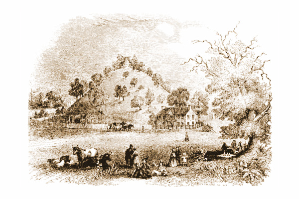
"The flats of Grave creek are a large scope of bottom land in Marshall county, (West) Virginia, and on the eastern shore of the Ohio river, which here runs due south. They extend from north to south about four miles, and contain about three thousand acres. Big and Little Grave creeks both empty into the Ohio at these flats, from which they derive their names. The creeks themselves doubtless derived their names from various tumuli or mounds, commonly called Indian graves, which are found on these flats, and especially between the two creeks.
These flats are composed of first and second bottoms, The first
bottom is about two hundred yards wide and runs the whole length
of the flats.
The great flood of 1832 was about ten feet deep on the first, but
lacked
about ten to twenty feet of the height of the second bottom, on
which all
the ancient Indian works and mounds are situated; no signs of them
being on the lower land. This (the largest) mound is surrounded
by various other mounds and ancient works, and in respect to the
surrounding localities, the situation, as respects defence, was
well chosen, on the brow
of the second bottom, and partially encompassed by steeps and ravines. 
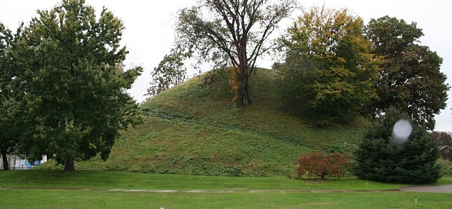
The mammoth mound is sixty-nine feet high. Its circumference at the base is over three hundred yards. It is the form of a cone, and has a flat top of fifty feet in diameter. This flat on the top of the mound, until lately, was dish shaped, The depth of the depression in the centre was three feet, and its width forty feet. This depression was doubtless occasioned by the falling in of two vaults, which were originally constructed in the mound, but which afterwards fell in; the earth sinking over them, occasioned the depression on the top. On the 19th of March, 1838, we commenced an excavation in this mound. We commenced on the north side, and excavated towards the center. Our horizontal shaft was ten feet high and seven feet wide, and ran on the natural surface of the ground or floor of the mound.
"At the distance of one hundred and eleven feet we came to a vault that had been excavated in the natural earth before the mound was commenced, This vault was dug out eight by twelve feet square and seven feet deep. Along each side and the two ends upright timbers were placed, which supported timbers that were thrown across the vault, and formed for a time its ceiling. These timbers were covered over with loosely hewn stone, of the same quality as is common in the neighborhood. These timbers rotted and the stone tumbled into the vault; the earth of the mound following, quite filled it. The timbers were entirely deranged, but could be traced by the rotten wood, which was in such a condition as to be rubbed to pieces between the fingers. This vault was as dry as any tight room; its sides very nearly corresponded with the cardinal points of the compass, and it was lengthwise from north to south.
 |
"In this vault were found two human skeletons, one of which had no ornaments or artificial work of any kind about it. The other was surrounded by about six hundred and fifty ivory beads, and an ivory ornament about six inches long, flat on one side and oval-shaped on the other. (This was a perforated tablet, with incurving sides. Like the beads, it was made of shell instead of "ivory.") The beads resemble button molds, and vary in diameter from three to five-eighths of an inch. In thickness they vary from that of common pasteboard to one-fourth of an inch. Above I count only the whole ones left. "After searching this vault, we commenced a shaft ten feet in diameter, at the center of the mound on top, and in the bottom of the depression before spoken of. At the depth of thirty-four or thirty-five feet above the vault at the bottom, we discovered another vault, which occupied the middle space between the bottom and top. It had been constricted in every respect like that at the base of the mound, except that its base lay east and west, or across that at the base, but perpendicularly over it. It was equally filled with earth, rotten wood, stones, etc., by the falling in of the ceiling. The floor of this vault was also sunken by the falling in of the lower one, with the exception of a portion of one end. |
"In the upper vault was found one skeleton only, but many trinkets, as seventeen hundred ivory beads, five hundred sea shells of the involute species, that were worn as beads, and five copper bracelets that were about the wrist bones of the skeleton. There were also one hundred and fifty pieces of isinglass (mica), and the stone, facsimile drawing of which I send you herewith (this is the famous "Grave Creek Tablet.") . The beads found in this vault were like those found in the lower one, as to size, materials, decay, etc. The five bracelets weigh seventeen ounces. The pieces of isinglass are but little thicker than writing paper, and are generally from one and a half to two inches square'; each piece had two or three holes through it about the size of a knitting needle, most likely for the purpose of sewing or in some way fastening them to the clothing. "The beads were found about neck and breast bones of the skeletons. The sea shells were in like manner distributed over the neck and breast bones of the skeleton in the upper vault. The bracelets were around the wrist bones. The pieces of isinglass were strewn all over the body. The stone with the characters on it was found about two feet from the skeleton.
"The skeleton first found in the lower vault, was found lying on the back, parallel with and close to the west side of the vault. The feet were about the middle of the vault; its body was extended at full length, The left arm was lying along the left side; the right arm as if raised over the head, the bones lying near the right ear and crossed over the crown of the head. The head of this skeleton was toward the south. There were no ornaments found with it, The earth had fallen and covered it over before the ceiling fell, and thus protected, it was not much broken.
"The second skeleton found in this vault, and which had the
trinkets about it, lay on the west side, with the head to the east,
or in the
same direction as that on the opposite side.  The
feet of this one were
likewise near the center of the west side. The earth had not crumbled
down over it before the ceiling fell, consequently it was much broken,
(as was also that in the upper vault.) There is nothing in the remains
of any of these skeletons which differs materially from those of
common
people.
The
feet of this one were
likewise near the center of the west side. The earth had not crumbled
down over it before the ceiling fell, consequently it was much broken,
(as was also that in the upper vault.) There is nothing in the remains
of any of these skeletons which differs materially from those of
common
people.
"The skeleton in the upper vault lay with its feet against the south side of the vault, and the head towards the northeast. It is highly probable that the corpses were all placed in a standing position, and subsequently fell.
"The mound is composed of the same kind of earth as that around it, being a fine loamy sand, but differs very much in color from that of the natural ground. After penetrating about eight feet with the first or horizontal excavation, blue spots began to appear in the earth of which the mound is composed. On close examination, these spots were found to contain ashes and bits of burnt bones. These spots increased as we approached the center; at the distance of one hundred and eleven feet within, the spots were so numerous and condensed as to give the earth a clouded appearance, Every part of the mound presents the same appearance, except near the surface. I am convinced that the blue spots were occasioned by depositing the remains of bodies consumed by fire." - Tomlinson, 197, et seq. condensed,
"The mode of its construction appears to have been by carrying earth in bags or vessels, from the plain, and emptying them out by hand. The earth is entirely made-earth, without the least appearance of stratification. ... The removal of the earth appears to have been made in small portions, from several points, and at convenient intervals."- Schoolcraft, Grave Creek, 373,
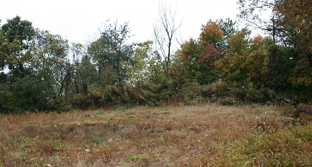
This clearing was left after Indian Knob Tower's stone remains were removed by a developer to build a road. Only a small ridge of rocks remains across the fresh clearing, on the bluff edge overlooking Grave Creek Mound.
| Code | Location | Latitude | Longitude | Source | |
| grcrm | Grave Creek Mound | 39.91686111 | -80.74472222 | GPS | 4m |
Located in Moundsville, WV.