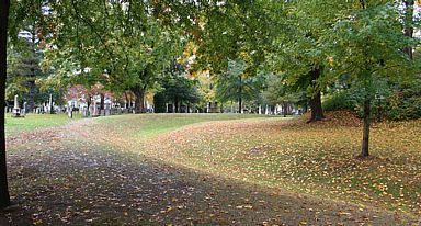
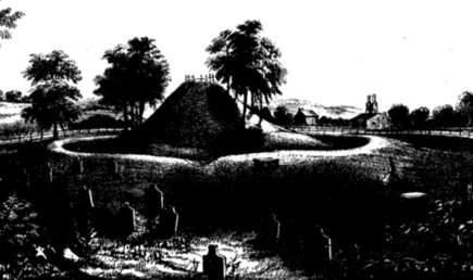
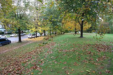
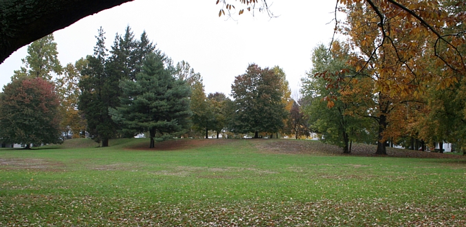
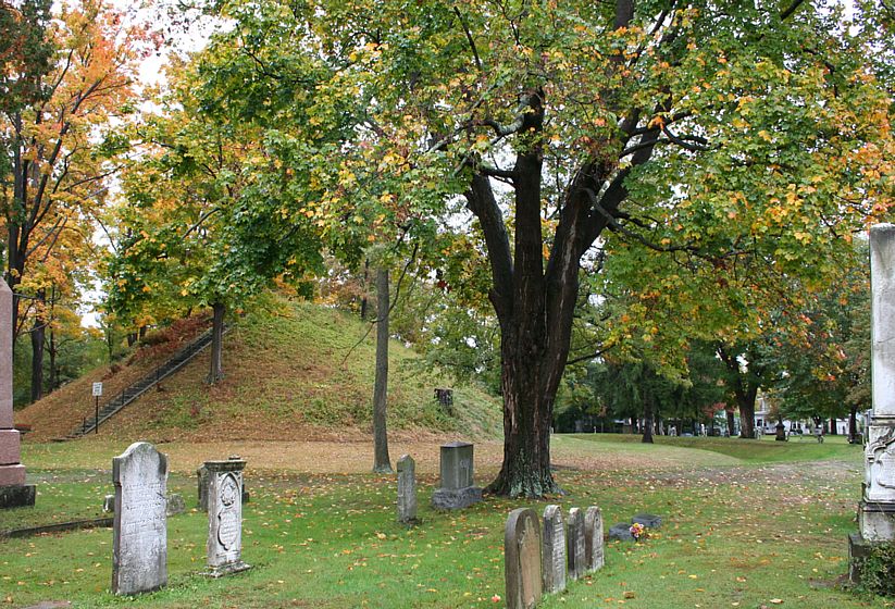
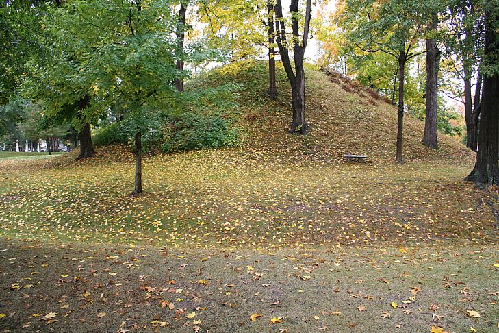
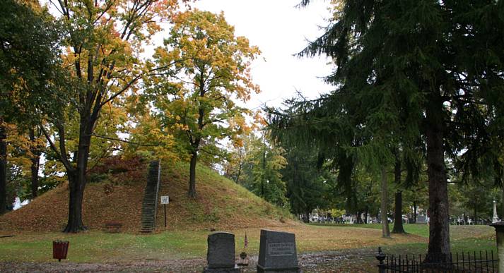
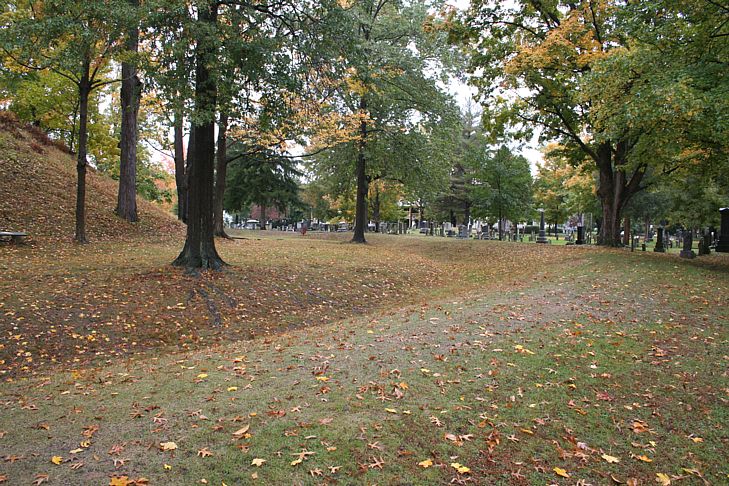
"To the south of the smaller enclosure is a finely formed truncated
mound, (a
view of which is given in a subsequent Plate) thirty feet high, and
surrounded by a
circular wall, constituting a perfect ellipse, the transverse and conjugate
diameters
of which are two hundred and thirty feet, and two hundred and fifteen
feet
respectively.3 This beautiful monument is now enclosed in
the public cemetery,
and is carefully guarded from encroachment. A flight of steps ascends
to its
summit, on which seats are disposed, and from which a beautiful prospect
is
commanded.4 In the vicinity occur several fragmentary walls,
as shown in the map.
 "Excavations,
or "dug holes " are observable at various
points around these
works. Near the great mound are several of considerable size. Those
indicated
by and in the plan have been regarded and described as wells. Their
regularity and former depth are the only reasons adduced in support
of this
belief. The circumstance of regularity is not at all remarkable, and
is a common
feature in excavations manifestly made for the purpose of procuring
material
for the construction of mounds, etc. Their present depth is small,
though it is
represented to have been formerly much greater. There is some reason
for
believing that they were dug in order to procure clay for the construction
of pottery
and for other purposes, inasmuch as a very fine variety of that material
occurs
at this point, some distance below the surface. The surface soil has
recently
been removed, and the manufacture of bricks commenced. The "clay
lining
which has been mentioned as characterizing these "wells," is
easily accounted
for, by the fact that they are sunk in a clay bank! "Excavations,
or "dug holes " are observable at various
points around these
works. Near the great mound are several of considerable size. Those
indicated
by and in the plan have been regarded and described as wells. Their
regularity and former depth are the only reasons adduced in support
of this
belief. The circumstance of regularity is not at all remarkable, and
is a common
feature in excavations manifestly made for the purpose of procuring
material
for the construction of mounds, etc. Their present depth is small,
though it is
represented to have been formerly much greater. There is some reason
for
believing that they were dug in order to procure clay for the construction
of pottery
and for other purposes, inasmuch as a very fine variety of that material
occurs
at this point, some distance below the surface. The surface soil has
recently
been removed, and the manufacture of bricks commenced. The "clay
lining
which has been mentioned as characterizing these "wells," is
easily accounted
for, by the fact that they are sunk in a clay bank!
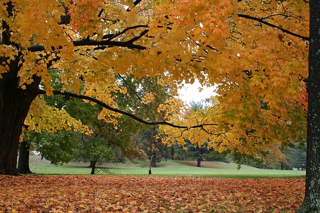
"Upon the opposite side of the Muskingum river are bold precipitous
bluffs
several hundred feet in height. Along their brows are a number of small
stone
mounds. They command an extensive view, and overlook the entire plain
upon
which the works here described are situated.
 "Such are the principal facts connected with these interesting
remains. The
generally received opinion respecting them is, that they were erected
for defensive
purposes. Such was the belief of the late President HARRISON, who visited
them
in person, and whose opinion, in matters of this kind, is entitled
to great weight.
The reasons for this belief have never been presented, and they are
not very
obvious. The number and width of the gateways, the absence of a fosse,
as well
as the character of the enclosed and accompanying remains, present
strong objections
to the hypothesis which ascribes to them a warlike origin. And it may
here
be remarked, that the conjecture that the Muskingum ran at the base
of the graded
way already described, at the period of its erection, seems to have
had its origin
in the assumption of a military design in the entire group. Under this
hypothesis
it was supposed that the way was designed to cover or secure access
to the river
an object which it would certainly not have required the construction
of a passageway
one hundred and fifty feet wide to effect. The elevated squares were
never
designed for military purposes,—their very regularity of structure
forbids the
conclusion. They
were most likely erected as the sites for structures which have
long since passed away, or for the celebration of unknown rites, —corresponding
in short, in purpose as they do in form, with those which they so
much resemble in Mexico and Central America. Do not these enclosed
structures give us the clue
to the purposes of the works with which they are connected? As heretofore
remarked, the sacred grounds of almost every people are set apart
or designated
by enclosures of some kind. "Such are the principal facts connected with these interesting
remains. The
generally received opinion respecting them is, that they were erected
for defensive
purposes. Such was the belief of the late President HARRISON, who visited
them
in person, and whose opinion, in matters of this kind, is entitled
to great weight.
The reasons for this belief have never been presented, and they are
not very
obvious. The number and width of the gateways, the absence of a fosse,
as well
as the character of the enclosed and accompanying remains, present
strong objections
to the hypothesis which ascribes to them a warlike origin. And it may
here
be remarked, that the conjecture that the Muskingum ran at the base
of the graded
way already described, at the period of its erection, seems to have
had its origin
in the assumption of a military design in the entire group. Under this
hypothesis
it was supposed that the way was designed to cover or secure access
to the river
an object which it would certainly not have required the construction
of a passageway
one hundred and fifty feet wide to effect. The elevated squares were
never
designed for military purposes,—their very regularity of structure
forbids the
conclusion. They
were most likely erected as the sites for structures which have
long since passed away, or for the celebration of unknown rites, —corresponding
in short, in purpose as they do in form, with those which they so
much resemble in Mexico and Central America. Do not these enclosed
structures give us the clue
to the purposes of the works with which they are connected? As heretofore
remarked, the sacred grounds of almost every people are set apart
or designated
by enclosures of some kind.
"The absolute identity in size between the smaller enclosure,
(which varies a little
from a true square,) and several of those which occur in the Scioto
valley, should
not be overlooked, in any attempt to educe the character and design
of the group.
That there is some significance in the fact is obvious. ....
The valley of the Muskingum is for the most part narrow, affording
few of those broad, level, and fertile terraces, which appear to have
been the especial favorites
of the race of mound-builders, and upon which most of their monuments
are found.
As a consequence, we find few remains of magnitude in that valley,
until it assumes a different aspect, in the vicinity of Zanesville,
ninety miles from its mouth .... "
Footnotes:
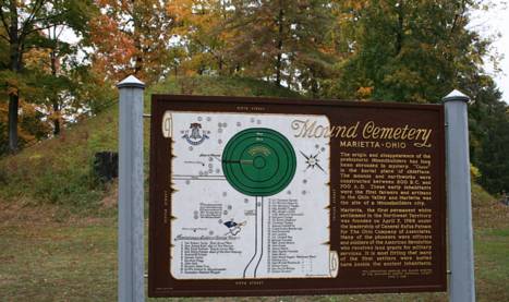
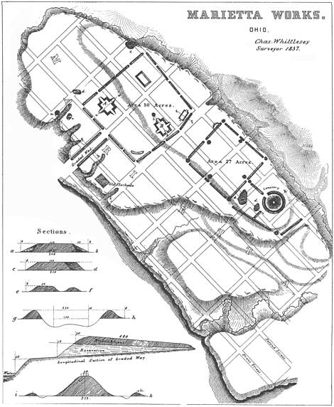
1.) The map presented by Squier and Davis was first drawn
from a careful survey in 1837 by CHARLE
WHITTLESEY, Esq., Topographical Engineer of the State, under the
law authorizing a Geological and Topographical
Survey of Ohio. (Herewith drawing is a partial version, condensed
to the monuments area and sections. Click for a larger file.)
2.)
The description of the two principal truncated pyramids embodies
the substance of an account of the same, published by Dr, S. P. HILDRETH
of Marietta, in the " American
Pioneer " for June, 1843
the entire fidelity of which has been attested by actual survey.
3.)
Such is the result of careful measurements made by Dr. JOHN LOCKE,
whose accuracy in matters of this kind, as in all others, is worthy
of emulation.
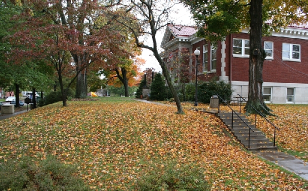
4.) A very laudable disposition has been manifested, on the part
of the citizens of Marietta, to preserve the interesting remains
in their midst. The Directors of the Ohio Land Company, when they
took possession of the country at the mouth of the Muskingum, in
1788, adopted immediate measures for the
preservation of these monuments. To their credit be it said, one of
their earliest offcial acts was the
passage of a resolution, which is entered up n the journal of their
proceedings, reserving the two
truncated pyramids and the great mound, with few acres attached to
each, as public squares. They
placed them under the care of the future corporation of Marietta, directing
that they should be embellished
with shade trees, when divested of the forest which then covered them,
which trees, it was added,
should be of native growth, and of the varieties named in the resolution.
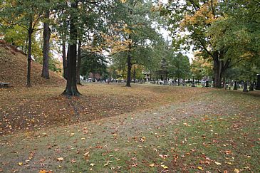
 The great mound with its surrounding
square was designated as a cemetery, and placed under the control of
trustees, Ten years ago,
these structures being yet unenclosed and much injured by the rains
washing through the paths caused by
the cattle that roamed over them, the citizens raised a sum of money
adequate to the purpose, and fully
restored them. The magnificent avenue named, not inappropriately, by
the Directors
Sacra Via.,
Sacred Way, but now generally known as the "Covered Way," was
also preserved by a special resolution
of the Company, "never to be disturbed or defaced, as common
ground, not to be enclosed." One
of the streets of Marietta, Warren street, passes through this avenue.
It is, of course, impossible to resist
encroachments upon the walls of the enclosures, which are rapidly disappearing.
Had a similar enlightened policy marked the proceedings of all the
early companies and settlers of the
West, we should not now have occasion to regret the entire obliteration
of many interesting remains of
antiquity. Or did a similar disposition exist generally, there would
be less necessity for a careful
systematic, and immediate survey of our remaining monuments. The works
at Chilicothe, Circleville, Cincinnati, and St, Louis, might have been
preserved with all ease; and would have constituted striking
ornaments to those cities, to say nothing of the interest which would
attach to them in other points of
view. It is proper to observe, that the facts embraced in this note were
kindly communicated by Dr. S,
P. HILDRETH, of Marietta." The great mound with its surrounding
square was designated as a cemetery, and placed under the control of
trustees, Ten years ago,
these structures being yet unenclosed and much injured by the rains
washing through the paths caused by
the cattle that roamed over them, the citizens raised a sum of money
adequate to the purpose, and fully
restored them. The magnificent avenue named, not inappropriately, by
the Directors
Sacra Via.,
Sacred Way, but now generally known as the "Covered Way," was
also preserved by a special resolution
of the Company, "never to be disturbed or defaced, as common
ground, not to be enclosed." One
of the streets of Marietta, Warren street, passes through this avenue.
It is, of course, impossible to resist
encroachments upon the walls of the enclosures, which are rapidly disappearing.
Had a similar enlightened policy marked the proceedings of all the
early companies and settlers of the
West, we should not now have occasion to regret the entire obliteration
of many interesting remains of
antiquity. Or did a similar disposition exist generally, there would
be less necessity for a careful
systematic, and immediate survey of our remaining monuments. The works
at Chilicothe, Circleville, Cincinnati, and St, Louis, might have been
preserved with all ease; and would have constituted striking
ornaments to those cities, to say nothing of the interest which would
attach to them in other points of
view. It is proper to observe, that the facts embraced in this note were
kindly communicated by Dr. S,
P. HILDRETH, of Marietta." |
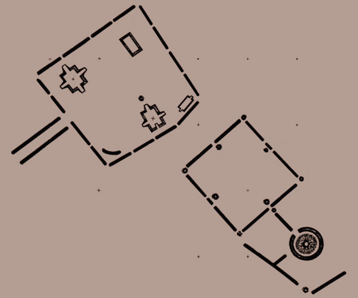
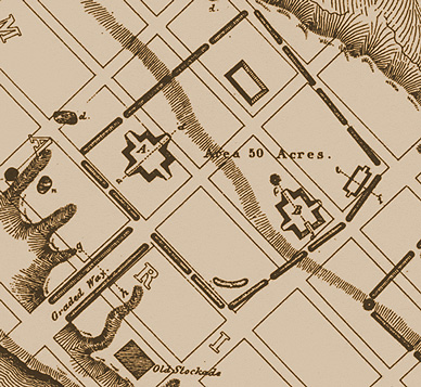
 It
is one hundred and eighty-eight feet long by one hundred and thirty-two
wide, and ten high. Midway upon each of its sides are graded ascents, rendering
easy the passage to its top. These grades are twenty-five feet wide and
sixty feet long. The next in size is marked B in the plan, and is one hundred
and fifty feet long by one hundred and twenty wide, and eight feet high.
It has three graded passages to its top, viz. upon the north, west, and
east. Those at the sides are placed somewhat to the north of the centre
of the elevation. Upon the south side there is a recess or hollow way,
instead of a glacis, fifty feet long by twenty wide. This elevation is
placed upon an easy swell or ridge of land, and occupies the most conspicuous
position within the enclosure, every part of which is commanded from its
summit. A few feet distant from the northern glacis, is a small conical
mound, surrounded with shallow excavations from which the earth for its
construction, and, perhaps , for the construction in part of the pyramidal
structure, was taken. To the right of the elevation, and near the eastern
angle of the enclosure, is a smaller elevation one hundred and twenty feet
long, fifty broad, and six feet high. It had graded ascents at its ends,
similar in all respects to those just described. It is now much obliterated.
Near the northern angle of the work is another elevation, not distinctly
marked. The two larger squares are covered with a close turf, and still
preserve their symmetry. Indeed, no erections of earth alone could surpass
them in regularity. They are perfectly level on the top, except where some
uprooted tree has displaced the earth.
It
is one hundred and eighty-eight feet long by one hundred and thirty-two
wide, and ten high. Midway upon each of its sides are graded ascents, rendering
easy the passage to its top. These grades are twenty-five feet wide and
sixty feet long. The next in size is marked B in the plan, and is one hundred
and fifty feet long by one hundred and twenty wide, and eight feet high.
It has three graded passages to its top, viz. upon the north, west, and
east. Those at the sides are placed somewhat to the north of the centre
of the elevation. Upon the south side there is a recess or hollow way,
instead of a glacis, fifty feet long by twenty wide. This elevation is
placed upon an easy swell or ridge of land, and occupies the most conspicuous
position within the enclosure, every part of which is commanded from its
summit. A few feet distant from the northern glacis, is a small conical
mound, surrounded with shallow excavations from which the earth for its
construction, and, perhaps , for the construction in part of the pyramidal
structure, was taken. To the right of the elevation, and near the eastern
angle of the enclosure, is a smaller elevation one hundred and twenty feet
long, fifty broad, and six feet high. It had graded ascents at its ends,
similar in all respects to those just described. It is now much obliterated.
Near the northern angle of the work is another elevation, not distinctly
marked. The two larger squares are covered with a close turf, and still
preserve their symmetry. Indeed, no erections of earth alone could surpass
them in regularity. They are perfectly level on the top, except where some
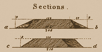
uprooted tree has displaced the earth. 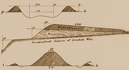 "This
section is constructed from measurements taken at a point midway between
the top and base of the grade. Measured between the summits of the banks,
the width of the way is two hundred and thirty feet. At the base of the
grade, the walls upon the interior are twenty feet high. From this point
there is a slight descent, for the distance of several hundred feet, to
the bank of the river, which is here thirty-five or forty feet in height.
It has been conjectured by some, that the river flowed immediately at the
foot of this way at the time of its construction. This is, however, mere
conjecture, unsupported by evidence. If admitted, it would give to this
monument an antiquity greatly superior to that of the pyramids, unless
the deepening of our river channels has been infinitely more rapid in times
past, than at present. But one fact favors the conjecture, and that is
the entire absence of remains of antiquity upon the beautiful terraces
to which this graded passage leads. They may nevertheless have been once
as thickly populated as they now are; and this passage may have been the
grand avenue leading to the sacred plain above, through which assemblies
and processions passed, in the solemn observances of a mysterious worship.
"This
section is constructed from measurements taken at a point midway between
the top and base of the grade. Measured between the summits of the banks,
the width of the way is two hundred and thirty feet. At the base of the
grade, the walls upon the interior are twenty feet high. From this point
there is a slight descent, for the distance of several hundred feet, to
the bank of the river, which is here thirty-five or forty feet in height.
It has been conjectured by some, that the river flowed immediately at the
foot of this way at the time of its construction. This is, however, mere
conjecture, unsupported by evidence. If admitted, it would give to this
monument an antiquity greatly superior to that of the pyramids, unless
the deepening of our river channels has been infinitely more rapid in times
past, than at present. But one fact favors the conjecture, and that is
the entire absence of remains of antiquity upon the beautiful terraces
to which this graded passage leads. They may nevertheless have been once
as thickly populated as they now are; and this passage may have been the
grand avenue leading to the sacred plain above, through which assemblies
and processions passed, in the solemn observances of a mysterious worship.

