Earthworks of Eastern North America
Seip and Baum Earthworks, Paint Creek Valley, Ohio

Seip Mound and Seip Earthworks
Seip Mound at Seip Earthworks

Originally, 10,000 feet of 10' high by 50' wide at the base earthen embankments enclosed over
120 acres at Seip Earthworks along Paint Creek in Ohio. Much of Seip Earthwork has been
greatly diminished by agriculture. Seip Mound is located near the center of the large circle.
At least 18 mounds are known from within and around the embankments. Placemarks.

Seip Earthworks outline drawing

Seip Mound, measuring 250' long, 150' wide and 30' high, is one of the largest mounds in the Middle Ohio River Valley.

Seip Mound, measuring 250' long, 150' wide and 30' high, is one of the largest mounds in the Middle Ohio River Valley.

Excavation of the mound in 1925-1926 revealed 122 buried and cremated human remains. Grave goods included Carolina mica, Isle Royale copper, Tennessee River Valley effigy pipes, and many freshwater pearls.

The interpretation plaque displays post mold patterns of several structures excavated in the 1970s.

About 10 percent of the original monument is preserved in Seip Mound State Memorial Park, including the best preserved portion of the large circle. This section was once a barnyard, and therefore is not plowed down to the same extent of the remainder of the embankments.

Note the GPS instrument on the embankment:
83.22119W, 39.24022N

Seip earthwork, section of the great circle.
View of the State Park, looking north from atop Seip Mound, provides a sense of the immense scale of the earthworks.

This view of the State Park, looking north from atop Seip Mound, provides a sense of the immense scale of the earthworks. The circle embankment is adjacent to the parked van, and the interpretation plaque is in the foreground along the trail.

Remains of several large structures were excavated between Seip Mound and the circle, in the area here depicted, near the plaque.

Viewing northwest from atop Seip Mound, the elevated remains of the three adjoining mounds are visible in the field. Far less discernable is the arc of the large circle.

The National Park Service recently acquired the portions of Seip Earthworks not preserved by Seip Mound State Memorial. That area is now a 168 acre unit of Hopewell Culture National Historical Park.

Viewing northwest from atop Seip Mound, the elevated remains of the three adjoining mounds are visible in the field

Atop Seip Mound viewing east.  GPS receiver at center of top of mound.

The GPS receiver is placed at the center of Seip Mound in this view looking east, downstream in the Paint Creek Valley.

Baum Earthworks, now obliterated by farming, was located about six km downstream on the opposite side of Paint Creek. Several other ancient monuments are also located in the valleys west of the Scioto River's concentration of earthworks.

  Squier and Davis first drew Seip Earthworks in 1847.

Squier and Davis first drew Seip Earthworks in 1847 to the scale noted in their here cropped artwork, at 1000 ft. to the inch. Subsequent survey by Thomas indicates the earlier drawing requires some rotation. The GPS readings indicated the mound is less near central to the large circle.

Thomas also cited a different length for the square side attached to the circle's enclosure, and noted loss of the southmost square wall.

Paint Creek Placemarks
with map overlays.

Monument
Diameter
Source
Baum Large Circle
1320
Squier and Davis

Seip Large Circle

1530
Romain 2000
Seip Small Circle
750
Romain 2000
 
Dimensions
Bearings
 
Baum Square
1123 x 1110.5
59.5, 150.6
Thomas 1894
Seip Square
1140 x 1139
79.23, 170.43
Thomas 1894
 
Height
Width
Length
 
Seip Mound
30
160
240
Squier and Davis 1847

Baum Earthworks

The Squier and Davis survey determined the Baum Large Circle diameter at 1,320' (402.3 m, 0.000010 CIR). Thomas reports the Baum Square sides at 1,123' (342.3m) and 1,110.5 (338.5m), slightly greater than the earlier Squier report of 1,080' (329.2m).

The Squier and Davis survey map of Baum Earthworks and adjacent works on paint Creek..

In this partial view of a Squier and Davis illustration, Baum Earthworks is seen in the lower left. The distance from Seip Mound to Baum Square is 0.05355° or about 3.7 miles (5.9 km) ENE.

The work in the lower right is a stone monument.

The so-called "fortified hill" was a settlement area.


Baum Earthworks and a truncated pyramid mound as depicted by Squier and Davis in 1848.
The Squier and Davis survey map of Baum Earthworks.


Sources, Bibliography, Readings.

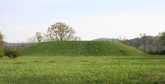
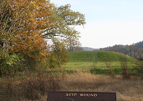
Baby, R. S. and S. M. Langlois 1979  Seip Mound State Memorial: Nonmortuary Aspects of Hopewell. In Hopewell Archaeology: the Chillicothe Conference, D. S. Brose and N. Greber, Kent State University, Ohio.

Baldia, Christel and Kathyrn Jakes, Photographic methods to detect colourants in archaeological textiles. The Journal of Archaeological Science, 34:519-525.

Mosher, Dave 2007 Forensic Photography Brings Color Back to Ancient Textiles (reporting on Baldia and Jakes).

"The materials we examined from Hopewell burial mounds show gradations of color under different light sources. That's significant for ancient textiles because it reveals technologies prehistoric Native peoples were capable of."

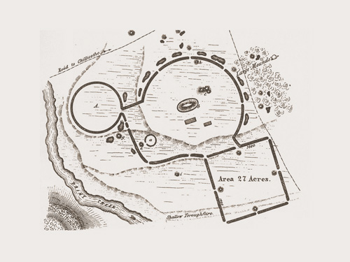
Squier Ephriam G., and Edwin H. Davis 1848. Ancient Monuments of the Mississippi Valley. Smithsoniam Institution.

Thomas, Cyrus 1894 Report on the Mound Explorations.

Woodward, Susan L. and Jerry N. McDonald, Indian Mounds of the Middle Ohio Valley


©2006 by James Q. Jacobs.  All Rights Reserved.  Permissions.  Contact.

Earthworks of Eastern North America
Seip Earthworks
Hopeton Works
Hopewell Earthworks
Liberty and High Bank
Cahokia Mounds
Indiana Earthworks
Grave Creek
Serpent Mound
   
Photo Galleries
South America
Mesoamerica
The Southwest
Rock Art
Pacific Northwest
Mt. St. Helens
Travel
Earthworks
Web Hubs by the Author
Home
Anthropology
Astronomy
Art
Writing