ArchaeoBlog 
  

text break bar image
Latitudes and Huacas

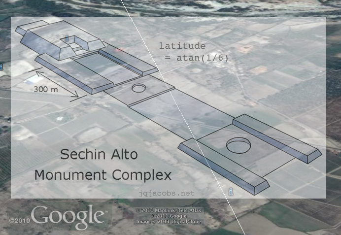
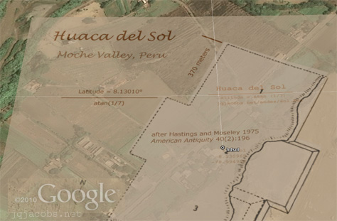
2011.12.28 - Again, I found an amazing image online, quite serendipitously, of the ancient monumental stone carving at Otuzco. Again also the site is one with cliff-carved niches. This time the significant capital is Cajamarca, in the Andes about half way around the world from the Longmen Grottoes in China .

I'm exploring, via the cyber globe, latitudes with specific mathematical properties. Having discovered Monk Mound is situated at atan 4/5 latitude, Ur Zigurrat at atan 3/5, Sechin Alto at atan 1/6, Huaca del Sol at atan 1/7, Chavin at asin 1/6, I recently explored more such lines in South America. Knowing my South American sites list is incomplete, targeted aerial inspection seemed a good idea. I found Otuzco on the atan 1/8 latitude near Kuntur Wasi and the ancient Andean capital of Cajamarca. The cluster of Panoramio image placemarks in Google Earth led me to notice the site.

text break bar image
Winter Solstice 2011 Approaches

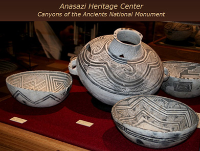
2011.12.20 - I found an amazing image online, quite serendipitously, of ancient monumental stone carving. Check this out, the Longmen Grottoes near ancient Louyang. At Luoyang, a significant capital in ancient China—the center of five dynasties, a "heavenly terrace" was used for celestial observation and calendar management. The imperial capital included an official school of teaching, learning and research. While trying to find the ruins on the cyber-globe, I was clicking image placemarks. Researching archaeological sites online keeps getting easier and more interesting, and importantly, incredibly more informative than imagined a few decades ago.

Near Luoyang in Google Earth, I noticed a dense forest of image placemarks. The ubiquity of high resolution digital cameras has resulted in an astounding amount of accessible, high-quality imagery on photo sharing websites. Our new geographic information systems are amazingly graphic. Google Earth displays a layer with Panoramio's geo-located imagery. I often keep Layers > Photos > Panoranio checked to enable viewing locations "on the ground" from many camera perspectives. Knowing the photo sharing domain references coordinates is also a particularly useful searching feature. I recommend exploring Google Earth's Panoramio layer at well-visited archaeology sites. It's no vacation to Machu Picchu, but today you really can see a lot of the world you want to travel too. The more images, the closer you should zoom in, to not miss some.

2011.12.20 - Another domain just sent a wave of visitors to the Hovenweep photo galleries. So, I've added new images of Holly House and 2650 x 1440 pixel deskpictures of Hovenweep Castle and Holly Tower. Click the images below to download the large deskpictures. Winter Solstice this year falls on Dec. 21 in my Pacific time zone. A happy holidays season to all.  


Vore Buffalo Jump

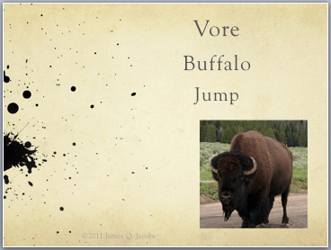
2011.07.21 - Vore Buffalo Jump has been simmering on my back burner for years; not being an ancient monument the reason.  Encountering Yellowstone National Park bison this summer put a capstone on my photos, already enhanced after a site revisit.  My long-promised Vore Buffalo Jump images are finally available in this PowerPoint:

Vore Buffalo Jump PowerPoint


Newark Earthworks and Interpretive Archaeology

2011.01.06 - Newark Earthworks is one of several Ohio earthworks being considered for U.S. Department of the Interior (DoI) submission to the United Nations Educational, Scientific and Cultural Organization (UNESCO) World Heritage List.  I write to focus attention on an important issue the submission brings to the fore, the would-be naming of Ohio monuments as the "Hopewell Ceremonial Earthworks."  At issue is employing archaeological interpretation to name ancient monuments.  Had this practice been in vogue in the 19th century, we would today be discussing "The Ten Lost Tribes Mounds" or some other similar such misnomer.  Transistory ideas should never be employed to name antiquities.

Great Circle Earthwork, Newark, Ohio

On Dec. 14, 2010, National Park Service (NPS) provided a "30-Day Notice of Opportunity for Public Comment on U.S. Nominations to the World Heritage List and Potential Additions to the U.S. World Heritage Tentative List" (PDF).  Comments are accepted on or before thirty days from the date. The public notice seeks comment on the next potential U.S. nominations and on possible additions to the U.S. list.  A Tentative List is a national list of candidate sites a country intends to consider for nomination.  A country can nominate a property after it has been on the Tentative List for one year, and is limited to nominating only two sites in any given year.  NPS last submitted to UNESCO World Heritage in January, 2008.
 
Earthworks on DoI's Tentative List include Fort Ancient State Memorial, Hopewell Culture NHP, Newark Earthworks State Historic Site (Wright Earthworks, The Octagon Earthworks, and Great Circle Earthworks), Serpent Mound, and Poverty Point NM.  DoI is considering whether to nominate any of the properties.  If a site is selected for nomination, public notice will be made of the decision, and draft nominations will be reviewed, amended if necessary, then provided to the World Heritage Centre no later than Sept. 30, 2011. The World Heritage Committee makes final decisions in the summer of 2013.

Octagon Earthwork, Newark, Ohio

Back to the issue at hand, interpretive archaeology and naming sites.  Why did officials designate a list of Ohio archaeological monuments the "Hopewell Ceremonial Earthworks" in the first place?  I think and expect that they should know better.  The historian who e-mailed me "I consider it the best interpretation I know of at this point" reinforces my argument suitably!  An individual consideration at some point in time is exactly the problem because interpretations not only change with time and with advances in knowledge, but, as is often stated in jest, "There are more interpretations than archaeologists because everybody wants to be one."  Perhaps the responsible officials were not archaeologists.

I've previously presented some Woodland Culture earthworks in a series of photo galleries and discussed them in various articles.  I employed Newark as an example while addressing methods in Temporal Epoch Calculations, an introduction to research considerations regarding temporal variables.  The material in my next blog post is new and will be permalinked as an additional entry in Newark Archaeogeodesy, Assessing Evidence of Geospatial Intelligence in the Americas.  In 2009, I also commented on misinterpretating earthworks when ancient religious beliefs were seemingly being divined and applied to the long deceased:

"Contemporary religious interpretations of the past have entered into recent popular dialogue about the Great Hopewell Road. Several archaeologists are equating the earthwork with 'pilgrimage' and Newark with a presumed 'Holy Land' of some sort, attracting distant travelers along the 'holy pilgrim's path' because the 'basic idea is pilgrimage.' Old World religious conceptions should not be super-imposed on Native American cultures. Just like it was wrong to say the Ten Tribes of Israel built Newark, so also it is wrong to call Newark a Jerusalem or Mecca, especially when there is no material evidence to go with the belief."

The distinction between material evidence and interpretation is too frequently blurred in archaeological writing, and is often non-existent in popular literature.  This issue is compounded when pet interpretations are used to name sites.  The logic of the problem is so obvious, I do not feel I need to present more argumentation.  Instead, I want to move forward and release some important evidence reinforcing a very different interpretation.  The interpretation I favor is that the builders possessed geodetic capabilities and advanced knowledge of astronomy far exceeding their contemporaries across the Atlantic, knowledge their eventual conquerors and agents of their genocide were blind to.  The astronomy interpretation of Newark and other earthworks has significant supportive empirical evidence, and, unlike the religious/pilgrimage/ceremonial ideation, at least the evidence is incontrovertible science no matter how it is interpreted. 

"What is the evidence?" should be your first question, of course.  I present new findings in the next ArchaeoBlog entry. I've added a lunar standstills section to Eclipses, Cosmic Clockwork of the Ancients, a discussion in the broader context of fundamental astronomy.  Also, I amended AeGeo code and added related terms (aegeo_calc_v2012.xls).  Updates of applets will follow, including some fundamental reformulations to improve the precision of temporal terms of astronomical constants and derived variables.  The precision of relationships of Newark Earthworks to other global monuments required improving the temporal accuracy of my applications to assess the hypothetical accuracy of the ancient astronomers.


text break bar image
Newark Earthworks and the Lunar Standstill Period

2011.01.24 - The lunar standstill period results from the turning of the axis of lunar orbit.  Inclination of the earth's axis (obliquity) together with solar orbit results in the sun rising and setting north and south of due east and due west during the course of each year. In the case of the moon, lunar orbit inclination either adds to or subtracts from the moon's swing back and forth across the celestial equator.  Unlike the sun, the moon shifts north and south on the horizon every 27.22 days (the lunar nodal period).  The moon's maximum rise-set angle from east-west recurs in a mean period of 18.613 years, one lunar standstill and just over one turn in space of the direction of the lunar orbit axis.

One long-standing interpretation of Newark Octagon is intentional alignments to the lunar standstill rise and set extrema. The hypothesis first appeared....

Continued at permalink:
Newark Archaeogeodesy
Assessing Evidence of Geospatial Intelligence in the Americas


SOUTHWEST Archaeology - NEW PowerPoint Versions of Photo Galleries

A dozen new PowerPoints are in the SOUTHWEST Anthropology and Archaeology pages.

anasazi heritage center powerpoint

Abó Mission and Ruins - 1.8 MB
Anasazi Heritage Center - 3.5 MB
Aztec Ruins - 3.0 MB
Chaco Canyon NHP - 4.6 MB
Pueblo Bonito - 2.1 MB
Coronado State Monument - 1.0 MB
Edge of the Cedars Museum and Ruins - 3.2 MB
Gran Quivira - 1.9 MB
Maxwell Museum - 1.8 MB
Mesa Verde - 4.6 MB
Pecos Pueblo - 2.9 MB
Quarai - 1.2 MB


Watching Eclipses, Counting Orbits
a PowerPoint with AeGeo Code

watching eclipses, counting
                                  orbits powerpoint

 
ArchaeoBlog
An archaeology web log by James Q. Jacobs

2022 -  2021 -  2020 -  2019 -  2018 -  2017 -  2016 -  2015 - 
2014 -  2013 -  2012 -  2010 -  2009 -  2008 -  2007

betatakin ruin deskpicture link
Southwest Spring 2007 Travel Posts

The Original ArchaeoBlog Pages, Fall 2005:
Mound Builders of the Eastern Woodlands

miamisburg mound

 
EDUCATORS: Use my images free and without hassle - Permissions
Home  |  Archaeology  |  Astronomy  |  Photo Galleries   |  Contact and Feedback

"Antiquity willfully veils the truth so that the fool will go astray and only the wise may know." 
Phaedrus, writer of fables, writing in Rome.

 © 2011 by James Q. Jacobs. All Rights Reserved.
Follow me on
                      Twitter.