| 2022 ArchaeoBlog |
|
2022.01.01 - Part of my annual routine is updating data files and related web content. These two files have grown significantly with last year's additions. Not only are there more ancient monuments included, the Google Earth placemarks feature more information, links to sources and resources, and embedded photos and graphics.
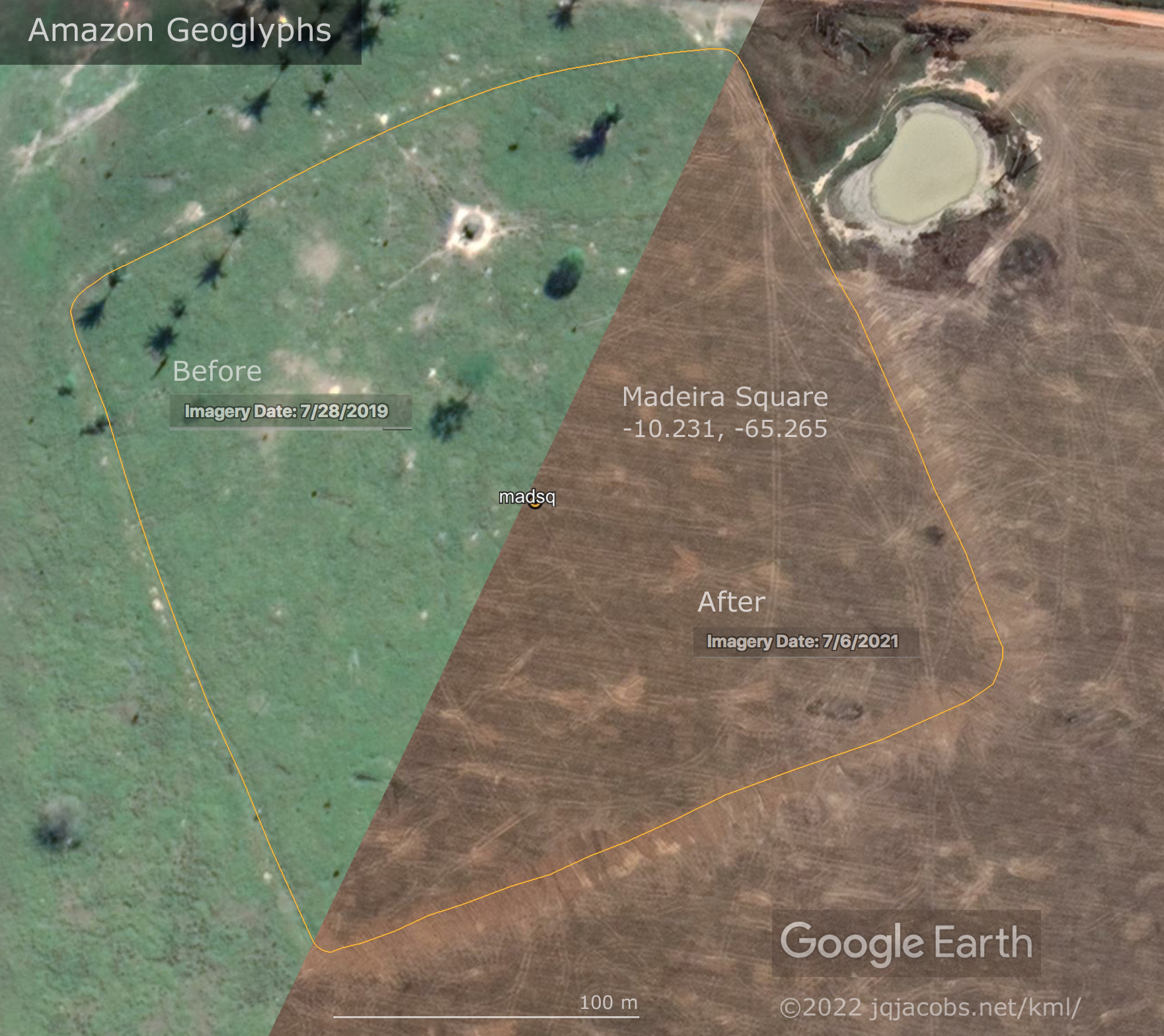
Last month I commemorated my fiftieth anniversary of completing Peace Corps service in Peru and moving to Oregon. Living in Peru including very briefly in the Machupicchu ruins, after training in Mexico and experiencing Mexico's amazing National Museum of Anthropology, led to my interest in and study of archaeology. Half a century later as I focus on specific regions, I'm still discovering how incomplete even my own understanding of the vastness of the archaeological record is. While updating the France KML file and restoring embedded images lost when Google deleted the Panoramio domain, just surfing the Web Archive photographers of neolithic ruins made me realize how incomplete my understanding of the sheer number of menhirs was. Returning to the Amazon virtually, surveying and resurveying higher resolution satellite imagery had the same effect, impressing me with how my own awareness falls so far short of what is actually out there. In the last few years my Amazon Geoglyphs KML file has grown from over 500 to over 1,100 monuments. I was repeatedly surprised to find truly immense monumental earthworks which have gotten almost no attention if any at all. I also plainly see landowners destroying these wondrous archaeological monuments for the sake of their own convenience exploiting the colonized Native lands. In the following before and after graphic notice the machinery marks made after June 2019 and before June 2021. For an idea of scale, Stonehenge is smaller than the stock pond. Click the image for a larger version.
I am also perceiving how quickly Amazon deforestation progresses. I noted how much difference just a few years has made in areas I resurveyed, so I zoomed out in Google Earth Pro and used the Historical Imagery tool to go back in time year by year to 1985 before deforestation, when the geoglyphs were still hidden under the trees, quite undiscovered by archaeology. On a macro scale, the before and after images drive home the degree to which the planet is being altered by humans. Is our understanding of the impact we have on the ecosystem complete enough to avoid a catatrophic collapse? Does this one ancient monument foreshadow before and after on a planetary scale? The more we learn, the more we realize how little we know, and that can be a discomforting awareness. The sum of many individuals acting in self interest can be very destructive on a larger scale. The Amazon today is not the same place I left 50 years ago.  Previous Years Linked Below |

