| 2019 ArchaeoBlog |
|
2019.12.21. - Happy Winter Solstice - Of course, for the southern hemisphere today is summer solstice. In our globalized world, a better designation than winter and summer solstice is required, so Happy December Solstice Everyone. The actual moment this year when the north pole is tilted away from the sun the maximum is 8:19 PM Pacific time. My research on Machupicchu continues and new findings have extended the amount of time the analysis is taking well beyond expectations, an exciting development limiting what I can present so far. Nonetheless, the updated sites placemarks are ready for sharing. Included in the sites folder is a methodology folder and some discussion of the problem of determination of precise coordinates, the correlated margins of error, and the subsequent confidence level in results. Today there is no substitute for precise Global Positioning System (GPS) data and I avail of all I can obtain. Even so, not all GPS data is of equal precision and the precision of the data isn't necessarily stated with the source. To the extent possible I use GPS data for site coordinates and when recording my own data annote the GPS margin of error. In many parts of the world Google Earth (GE) has high resolution imagery positioned with accuracy sufficient for many purposes of my studies as confirmed by comparison with my own GPS data of Eastern Woodlands and Southwest monuments. My own GPS data also allowed observing improvement of accuracy over time with GE high resolution imagery updates, albeit my GPS data published in Google Earth Communities may have even been used in positioning the aerial image updates. When obtaining and recording GE coordinates I database my access date to account for the satellite image placement adjustments over time. What is most relevant about GE precision in relation to Machupicchu is the terrain, vertical mountains. Almost all satellite imagery has an oblique camera angle, and with steeper terrain the margin of error in all probability is proportionally greater. I've considered many of my Machupicchu research results preliminary due to this problem. Recently, by crowd sourcing GPS files published online, I determined more precise position data, including a mean Waynapicchu summit coordinate from thirty hiker track summit datums and a Machupicchu summit mean from eighteen GPS files. I downloaded selected GPS files only, those with the best precision. I also used numerous GPS tracks to determine which GE Historical Imagery placement of the Machupicchu ruins was most reliable before updating coordinates for architectural features. Having greater confidence in the resultant data, I also expanded the sites folder with more GE-based architectural features along with more of the caves, carved in situ rocks, and known astronomical observation positions.
Download: Machupicchu Sites KML file for Google Earth — 200 KB. The updated Machupicchu Sites KML embeds numerous photos in most of the placemarks. Photography is an important aspect of ancient monument research, and the amount of shared photography online is yet another valuable crowd-sourced asset I employ. Due to Google deleting the Panoramio domain, I had to waste a lot of time updating the links to Web Archive URLs to restore the previous version's imagery. In the process more images were selected and embedded. I hope the copious amount of photography aids in understanding the significance of Machupicchu. Stay tuned for the study results in the Machupicchu Arcs KML coming soon.
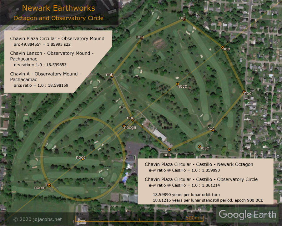
2019.10.19. - Machupicchu Arcs KML coming soon with research results and updated site data. Meanwhile, this new graphic as a teaser. Results related to Newark Earthworks have been added to the newark_arcs.kml.
2019.03.14 - Happy Pi Day. I've updated my KML collection of ancient monument pi relationships several times over the last year. The additions reflect recent research, including a focus on some of the oldest Neolithic monuments in Europe. Archaeologist Bettina Schulz Paulsson examined several thousand radiocarbon dating results from European Neolithic sites and published an article and database listing the oldest sites. I examined the relationships of the oldest monuments, and one of the relationships expresses pi quite precisely. From Er Grah Tumulus the arc distances ratio to Barnenez Tumulus and to Windmill Hill is one to pi.
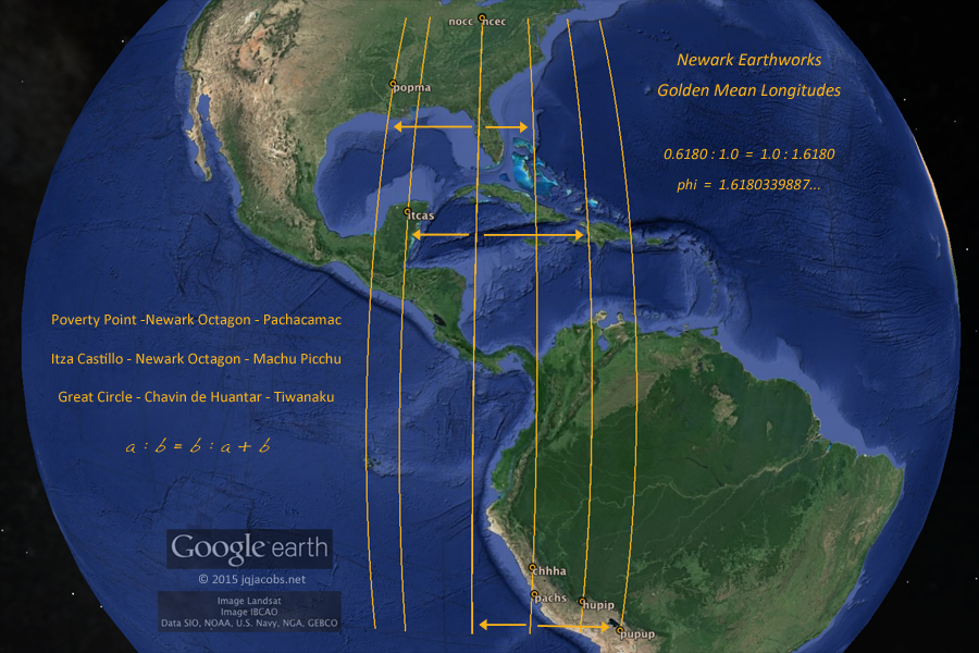
Windmill Hill, the 5,000 year old Neolithic causewayed enclosure, is part of the Avebury World Heritage Site and the type site of the Windmill Hill culture. Barnenez and Er Grah in Brittany have recorded older dates, making this pi monument relationship as old as Windmill Hill's circular henge. I'm celebrating #PiDay by posting KML files. Ancient Monument Phi Ratios is an updated version of the 2015 Golden Mean Longitudes file with more results. Yes, that's Phi, not Pi. I needed to replace dead link Panoramio image embeds with Web Archive photos, so I updated the entire file, reformatting, adding new research results, more placemarks, and more photos and graphics. Included is a Xiang folder featuring the phi latitude of Emporer Qin's tomb. The table below presents one of the placemark balloons.
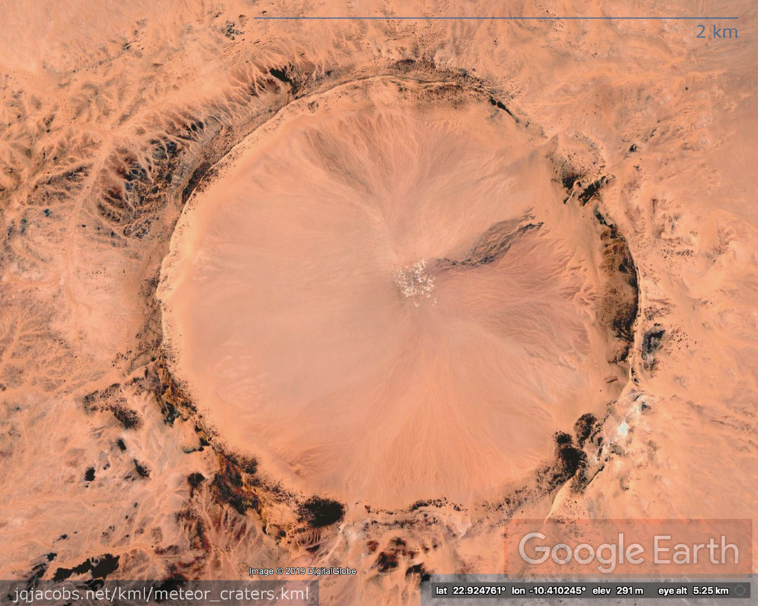
Meteor Craters - During the last year I followed a social media link to an article about the world's best meteor craters. I surprisingly learned a recent Pleistocene crater in Saharan Africa, Tenoumer Crater, is about the same age as the oldest known rock art. Of course, I wondered if modern humans were aware of the impact at the time and what import these landscape features had to later people. I've long wondered if the similarity of earthen henges and meteor craters is more than coincidence. I placemarked and measured some of the craters and checked their relationships to the major monuments which most resemble them. Another Saharan meteor crater, Aouelloul Crater, is the same size as Avebury henge. Two of the major monuments in the Phi KML file, Machu Picchu and the Sun Pyramid express a phi arc distance ratio with Aouelloul Crater. At the Giza pyramids the center-on-center arcs distances ratio to Avebury and to Aouelloul is five to four.
Late Pleistocene Tenoumer Crater, at two kilometers across, is larger than Aouelloul Crater, as wide as the spacing of the Newark Circles. The Tenoumer Crater walls would fully encircle Avebury's henge circle and Silbury Hill. The center-on-center arc distances ratio from Avebury to Newark's Observatory Circle and to Tenoumer Crater expresses the solar orbits per lunar standstill period constant seen in so many other Newark relationships.
From Newark Octagon the same ratio is expressed by the arc distances to Machu Picchu and Huangchengtai, the Chinese Neolithic capitol recently in the news when excavations revealed a massive stepped platform mound. Of course the news reports led me to find the academic reports and placemark the location. I noticed the Shimao walled city's latitude is near one-seventh of circumference from the pole. Avebury is precisely one-seventh of circumference from the equator, so the latitude ratio of the two locations is about three to four. I therefore checked the site-to-site relationships and noticed the number pi. The arc distance from the Shimao stepped mound at Huangchengtai to Silbury Hill, the immense mound at Avebury, equals 72.3427 degrees, and the tangent of 72.3432128485871... degrees equals pi.
Coming soon, a new Machu Picchu Archaeogeodesy article and KML file. Contact me for a preview of the KML file. I continue crowd sourcing GPS data and any contributions would be appreciated.
2019.01.01 - ArchaeoGeodesy XLS v2019 online. Excel research applet spreadsheet with coordinates for 5,000 mounds, pyramids, monuments, and ancient sites worldwide. Download - archaeogeodesy.xls 2019.01.12 - Updated Newark Archaeogeodesy, Monument Inter-Relationships v2019. Download - newark_arcs.kml 2019.01.27 - Updated Ancient Monuments in Google Earth - Spanning the globe, more than 15,000 placemarks of ancient monuments and anthropogenic features. All sites in ArchaeoGeodesy XLS v2019 are included in this update. Download - 4.0 MB Google Earth file - archaeogeodesy.kml
 Previous Years Linked Below | |||||||||||||||||||||||||||


