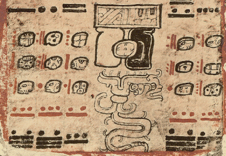
|
2009.02.02
-
Google Earth v5.0 (beta) has new layers - A recent
e-mail alerted me to new features in Google Earth 5.0. Video Tour.
The
'previous images' layer, controlled with a user chronology slider,
is very useful to archaeologists. Now, a variety of aerial images for
the same place provide more visual information. Also, click the toolbar
and v5 will record your place flying, allowing creation and sharing of
visual experiences. The new flying under the ocean feature is not
archaeology, but the vastly improved oeanographic imagery makes
visualization of the Pleistocene shoreline much easier. I still have
not explored the cosmology features. Will a temporal slider one day
allow capture of an ancient moonrise over the Octagon Work? Will the
ocean go back down?
I'm re-reading David Macaulay's 1979 Motel of the Mysteries,
a
hilarious tour of archaeological interpretation, methodology, and
critical thinking. His volume improves with age (perhaps just with my
age?). I scored an original cloth edition some library had withdrawn.
How such classics are discarded by libraries is another mystery. It has
the 50 cents tag, the 818 MAC tag, the bold WITHDRAWN stamps, and the
damage from tearing out the borrower's card sleeve and the library
label. Evidence of which library was sooo ignorant is now lost for all
time under a layer of pollutantus aliterati.
Anyway, if you are an
archaeo student, Motel of the
Mysteries is a must read before taking M&T,
Methods and Theory, and a
great read before taking your first anthropology class. I find it
useful in imagining how other cultures might interpret Eastern Usa
today, and how ancient humans might react to a real Great Urn when it
suddenly flushes. If concepts like a new layer of pollutantus
gravitas and pollutantus literati sound interesting,
check out the tome, or buy it cheap. Apparently, used book stores are
today's investor paradise, as libraries are disvested of knowledge.
|
"The
layers
of pollutantus gravitas and pollutantus literati
that covered the continent hardened into rock, and knowledge of the
"lost" civilization almost vanished entirely." David Macaulay, 1979
|

Does the Foot Fit
Britannia? -
2009.01.27
-
A recent e-mail exchange led to
reconsidering the
English foot as a geodetic construct. ... at Avebury's latitude, a
meridian degree measures 365,014.7 feet, not 365,256 as would be
expected for days per orbit ... where the foot fits matters. Permalink.
|
"At
Stonehenge,
there are 365,000 feet per meridian degree"
|
2009.01.24
-
Data Visualization in Archaeology - Place
relational linking in virtual space provides some of the same benefits
as going to the actual place, and time.

In Google Earth, I just
stumbled into another lost city of pyramids in Peru, Tucume. I also got
lucky at the bookstore today, and found a Lister and Lister Those
Who Came Before clothbound edition, a 1983 state-of-the-art visual
experience of Southwestern
archaeology in the United States National Parks System.
The only Tucume placemark
led to a GIS Development
magazine article, Natural and Cultural Large Site Modeling,
with
3-D site model graphics of Tucume and Xochicalco, Mexico.
Therefrom ensued this posting, and here are some highlights:
|
"Object
extraction
and modeling. In commercially available digital
photogrammetric software, object extraction functionality is restricted
to manual or semi-automated measurements together with the capability
of attribute data acquisition. The main applications are 3D modeling
...
"...
the
operator measures manually in the stereomodel a weakly structured
pointcloud, which describes the key points of an object. The software
then turns this pointcloud automatically into a structured 3D model,
which is compatible with CAD, visualization and GIS software. Texture
can be added to the geometry ... An example using CyberCity Modeler for
3D modeling of terrain and buildings in an archaeological application
was conducted for the pre-hispanic site of Xochicalco, Mexico, where an
urban center was reconstructed photogrammetrically from aerial images
...
"
...
the prehispanic site of Pinchango Alto ... we used a model
helicopter carrying a CMOS camera to acquire a series of vertical
aerial images for photogrammetric recording and 3D modeling of the site
and the surrounding terrain.
"...
automatic
photogrammetric processing allows for very efficient
procedures and for new kinds of results ..."
|
View a 3D model of the Tucume adobe complex textured with old aerial
images. Huaca Larga, is the 545 m long mound topped with an Inka stone
building. Below follows a Google Earth high resolution image of Tucume.
Another large huaca is not shown in this screen capture.

Also in the same issue, 3D
Source
for Egyptian Monument Information System and Replicas
of
world - a reality soon. Aerial survey and ground captured
data are being transformed into incredibly precise virtual replicas of
the world, especially when combinded with 3D visualization multimedia.
I was also recently excited by UCLA's
impressive Google Earth model of Karnak ruins, featuring a temporal
slider that allows you to construct the site chronologically!
Archaeologists have already added a temporal dimension to data
visualization. From an educators perspective, the interactivity
dimension is perhaps the most useful. When the viewer controls the
joystick to the past, that dimension becomes more engaging. The
floating placemarks (image above) lead to photographically rich
illustrations and websites. See: Digital
Karnak from UCLA.
|
"The
colossal
site of Karnak is one of the largest temple complexes in the
world, with an incredibly rich architectural, ritual, religious,
economic, social and political history. The Amun-Ra precinct, which
includes an astonishing number of individual temples, shrines and
processional ways, stands as a micro-cosmos of ancient Egypt."
|
Today, a friend sent links to 2008 data visualiation
awards,
including a link to Wordle.
I could not resist creating a few.

I've
completed
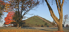
a PowerPoint of
Newark, Marietta and Grave Creek, assembling
the basic facts with graphics and links to the photo galleries and
placemarks.
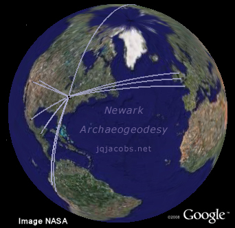
2009.01.06 - Newark
Archaeogeodesy - When is a prehistoric
monument an astronomical observatory? In both the popular press and
academic articles, this question is often not addressed when claims of
astronomical observations are made. Archaeogeodesy offers avenues
of inquiry for the question, albeit these transcend current paradigms
in archaeology. Well, reality is transcendental, independent of thought
about it. Paradigms in science, while resistant to alterations, do
crumble in the face of incontrovertible evidence even if slowly. The
Google Earth file I'm posting today, Newark Archaeogeodesy,
challenges archaeological paradigms with new evidence of the
sophistication of ancient geodesy and astronomy in the Americas.
As incontrovertible as the
actuality of arc distances and astronomical constants may be, I expect
considerable resistance from archaeologists regarding acceptance of
what the data
I present implies. As usual I'm trying to steer clear of
interpretations. I'm presenting evidence, "facts" I determine with
transparent methods. Nonetheless, the implications are very apparent.
If ancient astronomy and
geodesy questions interest you, check out the web article, Newark Archaeogeodesy,
where I'll present and discuss the findings in the Newark Arcs .kmz
placemarks file. If you detest challenges to your paradigms, well, run
and hide in that darkness because the monuments are not going to move
to new positions to accommodate your thinking. If you are new to Google
Earth, the virtual globe browser, check out my Ancient Monuments Placemarks
page first.
I first presented an Avebury
arcs file on Winter Solstice a year ago, in Winter
Solstice
and Long Barrows. A new Avebury Lunar Arcs
placemarks file focuses on the core Averbury area and lunar constants. It is also no
coincidence that today's release comes on the Epiphany instead of the
solstice, on the feast of the Three Wise Men in Christian traditions.
I'm not saying I expect readers will have an epiphany. The evidence
does infer new meaning for "wise men" and women in antiquity. That is
the discussion I hope will ensue, along with one about paradigms in
science and their origins in culture and history. The questions I offer
this semester are these: "Are we as 'wise' as humans were in
prehistory?" and "If not, how would we know?"
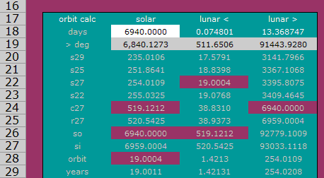
Several tools have been
updated for the upcoming semester. Epoch 2000 has been displaced by Epoch v2009. More variables
have been added to the code. The new version contains calculators
employing the codes, including an eclipse calculator. There are also
handy code and values lookup menus. Archaeogeodesy v2009 also
has these same new features, plus more site coordinates. Please report
any bugs. Happy Julian New Year and Happy Epihany too.
|